The two x 207metre high Poolbeg industrial chimneys situated standing at the mouth of Dublin Harbour were built and came into operation in the 1970’s and are amongst the tallest, hideous, eyesore structures in Ireland, visible from most areas of Dublin city.
The twin chimneys, with their distinctive red and white, dirty, rust streaked facades, when built had only a planned operational lifetime of 30-40 years. While Poolbeg itself continues today to be an operational power station, the existing chimneys were decommissioned back in 2006 and 2010; same no longer required for the 470MW gas turbine plant, which generates electricity for more than half a million Irish homes.
Bear this information in mind, when you hear that Dublin City councillors have called for the 50 year old chimneys to be listed as protected structures. To this end they have commissioned an architectural historian to research and report on the state of the chimneys, with a view to encasing them in concrete or fibreglass at a cost of several million euro.
Here in Thurles, Tipperary Co. Council officials, elected County Councillors and TD’s are on a totally different thought wave length.
Surely, the Poolbeg chimneys built in the 1970’s can hardly be observed as an international tourist attraction, while the Great Famine Double Ditch situated on Mill Road, Thurles Co. Tipperary has major tourism attraction potential, bringing benefit to a town centre currently on its knees.
Tipperary Co. Council officials, elected County Councillors and TD’s have now condemned the 175 year old Great Famine Double Ditch to total eradication, without the consent of those residents of the county who elected them and who continue to pay their massive salaries.
In the words of U.S. President Dwight D. Eisenhower’s Secretary of Defence, Mr Charles Erwin Wilson, which of these scenarios offers“most bounce for ounce” or “bang for your buck”, for the Irish taxpayer.
Choose! Restore and protect a 50 year old defunct and hideous eyesore, known as the Poolbeg chimneys; costing “Several million euro”, placing the debt burden on a State-owned company, who will be required to foot a continuous annual maintenance bill. Or Restore and protect an historic 175 year old Great Famine Double Ditch, Right-Of-Way and Mass Path, already slightly damaged by Tipperary Co. Council officials; which offers major tourism attraction potential, costing “Between €15,000 and €20,000”.
Survey Sent To All Thurles Elected Representatives Including Teachtaí DálaMr Jackie Cahill and Mr Michael Lowry.
A simple definition of the word “Hypocrisy“, is the practice of claiming to have higher standards, virtues, principles and beliefs that one in fact does not have and in most cases are unlikely to attain.
For examples of real “Hypocrisy” one does not have to go outside of County Tipperary or past page 4 of the “Tipperary Heritage Plan 2017 -2021” to find 2 major examples. View same by simply clickingHERE
First example of “Hypocrisy” comes from Cllr. Siobhán Ambrose, (Back between the years 2017 – 2021 Ms Ambrose was for a term Cathaoirleach, of Tipperary County Council.)
Quote: “The aim of the plan is to connect the citizens of Tipperary to their heritage and to make it an integral part of everyday life at the core of our communities. ……The aim of the plan is to connect the citizens of Tipperary to their heritage and to make it an integral part of everyday life at the core of our communities. Tipperary is a county with a rich heritage of which the Council and the citizens of Tipperary are very proud. Heritage projects provide a great opportunity for communities to come together and across the county local groups are working together to promote their localities. I have attended numerous events in the last months where people are celebrating their heritage, be it Built Heritage, Biodiversity and Wildlife, Culture, Music or Folklore. This strengthens our communities and contributes to our sense of place and puts heritage at the heart of our communities. I would like to acknowledge the work of these groups and individuals and hope that through the actions of this plan that we can work in partnership to look after this valuable asset and protect it for generations to come”.
The second example comes from the current reigning Chief Executive of Tipperary County Council, Mr Joe MacGrath.
Quote: “Our heritage is about our past, our present and our future and contributes greatly to the quality of life in our urban and rural communities. It is shared by all and is fully inclusive. Interaction with our heritage not only provides physical and mental health benefits, but contributes to overall well-being, while biodiversity is an essential component in the functioning of our environment.”
While we can’t be sure who wrote the above two introductory paragraphs to this ‘Tipperary Heritage Plan‘ document; we do know that both the Tipperary Co. Council officials named above, signed them; while receiving hefty salaries from Tipperary taxpayers.
Elected Representatives Questionnaire/Survey
The above survey is being sent to the following persons.
Elected Co. Councillors, Templemore / Thurles Municipal District.
Of the 6 questions forwarded to all elected representatives; the first 3 questions require only a simple YES or NO answer.
(1) Do you support the continued destruction of Thurles history and its historical sites, as in the past?
(2)Do you support the recently confirmed plans by Tipperary County Council to destroy the Great Famine Double Ditch historical site?
(3) As part of the Tipperary County Council development plans, in relation to this proposed inner relief road; has any alternative to the destruction of the Double Ditch been explored at Municipal district level or County level, Chaired by Tipperary Co, Council Chief Executive Mr Joe MacGrath?
(4) If you agree that the Great Famine Double Ditch should be taken from the people of Thurles and destroyed as part of Tipperary Co. Councils development plans, please now outline why you believe this to be so justified?
(5)If you disagree and believe the Double Ditch should be protected and marketed to the world; what action do you propose should now be undertaken to prevent its destruction?
(6) Will you be inviting ÆGIS and their Archaeological Impact Statement report author, namely Mr F. Coyne BA MIAI to return and acknowledge that the Great Famine Double Ditch actually exists? The qualified professional author Mr Coyne, should also explain how and why he excluded the phrases: “Double Ditch”, “Public Right-of-Way”, “Mass Path” and “Great Famine” from his Archaeological Impact Statement and declare that he was not requested to do so by any engineer or other official within Tipperary Co. Council. (See page 5 & 6 of link shown HERE.)
NB: The Questionnaire/Survey must be returned by Sunday 14th March 2021 and in the interests of openness & transparency, all detailswill be published in full, on this website for our readers.
The Great Famine Double Ditch that Thurles Elected Councillors say does not exist.
The following email from Cllr. Mr Jim Ryan was sent to me in the last few days. Same now confirms that, sadly, the Great Famine “Double Ditch” is to be destroyed, to construct an inner relief road to benefit the new Thurles Town centre, being developed at Slievenamon Road. [The former town centre at Liberty Square, Thurles, having been destroyed by Tipperary Co. Council assisted by Thurles Municipal District Councillors].
TheEmail from Cllr. Mr Jim Ryan, Mill Road, Thurles, sent on March 1st, 12:21pm, is show hereunder.
Dear George In a follow up to your concerns regarding the removal or closure of the double ditch walkway in Thurles I can now confirm the following as presented to me by Roads Section of Tipperary County Council.
The proposed new Thurles Link road from Clongour to the Mill Road will be going through a small section of the double ditch or College Lane walkway on the Mill Road side.
The walkway will remain fully accessible with a newly opened access point from the new link road on the Mill Road side after construction.
The construction of the new Link Road will require the removal of the existing walled entrance on the Mill Road side along with the removal of a small section of the walkway itself on that same side.
The council stated that a full and comprehensive Archeology (Read as Archaeology)and Envirnomental (Read as Environmental) Assessment was carried out as part of the process that highlighted no concerns to the council or An Bord Pleanala
The Double Ditch or College Lane walkway will not be closed off to the public or removed once the construction of the new link road is completed. It will however be reduced slightly in length with a new access point on the Mill Road side.
I hope this clarifies some of the issues raised by you. Yours, Cllr Jim Ryan Comhairle Contae Thiobraid Árann Tipperary County Council.
The content shown in the above email, to say the very least, is a watered-down version, designed to affect my silence.
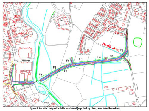
One example of this is that Mr Ryan has failed to notice that a further two-lane exit through the double ditch is designed to allow traffic onto the new road, from the new housing estate; see area/map reference indicated between F4 & F3. A second exit is designed possibly to connect to the rear of the Mary Immaculate College (formerly St. Patrick’s College). See between F6 & F5 on the map immediately published hereunder. Also on the map hereunder the Double Ditch has been shortened, by almost one half, compared to the cover map on our first video shown above. Same map referred to above is the first map ever recorded of this area in the 1800’s. This is deceit of the first order, by Council officials.
We now learn that none of our Municipal District Councillors can be trusted following the disclosure by Cllr. Ryan.
Tonight, I have replied to Cllr. Jim Ryan, Member of Thurles Municipal District, Council.
Sir,
Thank you for your communication of the 1st instant. My sincere apologies for failing to respond to your communication earlier.
I am fully aware, since June 3rd, 2019, that it was the intention of Tipperary Co. Council to demolish the Great Famine Double Ditch, latter situated within 500 meters of your principal private residence on the Mill Road, Thurles, Co. Tipperary.
It was to that end, indeed, that I contacted, in November 2019, Ms Rosin O’Grady, (Latter Tipperary Heritage Officer and Creative Ireland Co-ordinator), asking that she contact the National Monument Service, with a view to granting protection to this historic area. I was soon to realise that Ms O’Grady, despite her official title, is not fully independent of her titled duties, governed indeed by Thurles Municipal District Councillors and senior officials within Tipperary Co. Council.
Suffice is to state that Ms Rosin O’Grady has been instructed not to enter into further communication with me or has failed in her required duty as a County Heritage Officer.
You and your Council colleagues and Co. Council officials, including Chief Executive Mr Joseph MacGrath were informed regarding this wanton destruction of our local Thurles history, on May 24th 2020 (almost 10 months ago).
You Sir, including your County Council C.E. Mr Joe MacGrath, together with all elected Thurles Municipal District Councillors, and the Lowry Team, deliberately and with ill will, chose to ignore every communication sent to each and every one of them, while failing to acknowledge or even reply to any and all of my communications.
Following my complaint to the Standards in Public Office Commission(SIPO) regarding you and others of your Council colleagues, including TD’s Mr Jackie Cahill and Mr Michael Lowry; you were contacted by Registrar, Mr David Coleman, (Administrative officer, Corporate Services) regarding your failure to maintain proper standards of integrity; conduct, and concern for the public interest. It took you Cllr. Ryan, almost 3 years to inform me of what you knew, refusing to confirm the information which I had already informed you.
You will now please answer for the moment the following two questions:-
(1) Do you support this decision to remove yet another piece of Thurles history, which if properly marketed would benefit, greatly, the community of Thurles.
Note: I am aware that you are a senior, active committee member, with that grouping known as “The International Garden of Remembrance Committee”, (Chairman Mr John Worth), situated at St. Mary’s Graveyard, Church Lane, Thurles. You annually attend a ceremony in this garden to commemorate “An Gorta Mór – Ireland’s Great Hunger 1845-1849”. Indeed your group unveiled a large headstone of black marble, (latter which in the past I have strongly objected to its introduction, without planning permission), breaching, as it does, government heritage guidelines and regulations. Are you now going to support the destruction of a real piece of Thurles heritage, which Thurles can use to attract the ever elusive Thurles tourist?
(2) Do you or any other extended member of your family, either in the past or at any time in the future, expect to benefit, through the sale of land, or other advantage, conveniences or possessory rights, which is being now brought to bear, thus aiding the future destruction of the 175 year old Great Famine Double Ditch, at Mill Road, Thurles, Co. Tipperary.
Mr Ryan, you, your council colleagues, local TD’s and Co. Council Officials bring shame on this community and you are observed as no better than delinquent, vandals.
Your answers are of particular interest to me, in relation to steps I intend to take to reverse this outrageous, wilful and destructive decision.
Yours faithfully, George Willoughby.
I now invite Thurles Chamber of Commerce, Tipperary Tourism, Thurles Tourism groups and the Irish Government, to support the retention of this piece of valuable history. As a right-of-way Tipperary County Council are obliged to clean up this area and restore, that which they damaged on the watch of Mr Joe MacGrath, CE. Tipperary, Co. Council, in the last 9 years since 2013.
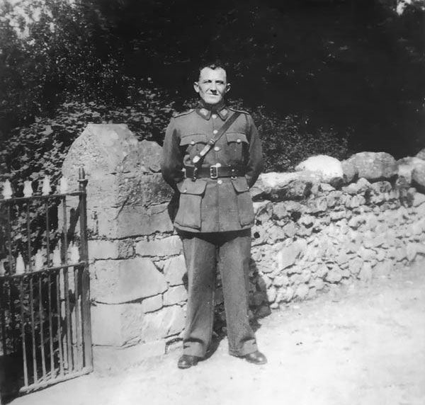
A new historical primary source sheds further light on the War of Independence here in Tipperary in 1921. Same comes from the written perspective of the late Mr Con Spain, (Commandant, 1st. Battalion, No.1 (North) Tipperary), formerly of Ard na Croise, Thurles, Co. Tipperary.
Readers will be aware that the 100 year anniversary of the death of Mr James (Jim) Devaney at hands of the R.I.C. in late January 1921 was commemorated recently here in North Tipperary.
Now correspondence between Mr Con Spain and Mr Devaney’s family has come to light, which gives Commandant Spain’s personal recollections into the events of that tragic day at a time when he states “respect for life and property was at a very low ebb.” In this never before published correspondence, the author Commandant Con Spain gives a unique insight into this difficult period in our county’s history.
Rare photograph of Cornelius (Con) Spain, [Commandant, 1st. Battalion, No.1 (North) Tipperary.]
Commandant Con Spain writes: –
“It happened in late January 1921. The war of Independence was raging and respect for life and property was at a very low ebb. We weren’t to know it then, but six months later the Truce was signed. It had all been worthwhile. [Note, the war of independence in Ireland ended with a truce on July 11th 1921.]
I had just about completed ploughing a five acre field, when I stopped for dinner and to fodder the other farm animals and my team of horses.
As I recollect it was about 1:30 p.m. in the afternoon, when I heard rifle fire coming from the direction of the main road, adjacent to the local pub. Scarcely turned 18 years, it took me only seconds to climb up into the largest benches of the hay barn, in hope of getting some view of the action which was evidently taking place.
Intervening ditches made it impossible to make out what was happening, but the bullets were coming uncontrollably close at this time. When the firing ceased, I heard a Crossley Tender moving down the main road towards Nenagh and Limerick. The occurrence of rifle fire was not uncommon in that area, in 1920/21, so I dismissed it from my mind and took my horses back to the field to finish ploughing the headlands. [Note. Crossley Motors was an English motor vehicle manufacturer based in Manchester, England, later taken over by British Leyland]
Around 4:00pm it’s started to rain and I moved up to shelter in a thatched cottage, which was on the field and near the roadway. I was resting over the outside half door; looking out on one of our neighbours ploughed fields, when I saw a skirmish line of about 30 to 40 men, advancing from the farthest hedge, which adjoined a small bye-road. They appeared to be searching for something and as they came near, I noticed that they were mostly in civilian clothing and all were armed. Since I was a member of the Irish volunteers, I quickly emptied all papers from my pockets and burned them in the turf fire in the cottage. I then left the shelter of the cottage and went to my team of horses, to resume my ploughing. [Note, a Skirmish Line, is an irregular open formation that is much more spread out in depth and in breadth than a traditional line formation].
However, at this point an R.I.C. constable whom I recognised as “Collins” and a well-dressed man in civilian clothing approached me from the laneway by the main road. They asked me if I had been in on the “ambush”. Since I knew nothing of this action, I could truthfully say that I was not involved. The civilian, whom I assumed to be a District County Inspector of the R.I.C., turned to the Constable and barked “Take him out and strip him”. They stripped and searched me but all they found was a small spanner. [Both they and I overlooked something that was in a small pocket of my inside vest. I’ll return to this later]. By now the main “search” party had reached us and the barrel of a Lee Enfield rifle was pointed at my forehead…. so close that I could see the gleaming grooves of the rifle down the barrel mouth…. incongruously, I thought “how in hell did he get the barrel that clean, when the one I had been using for 2 years never did shine like that”. This odd reflection only took a split second, before I made my most fervent act of contrition in expectation of summary execution. No shot came. The rifle was reversed and I was stuck under the chin by the rifle butt instead and knocked flat.
As I struggled to get up, I heard some of the riflemen calling from about 30 yards to my rear. I was unceremoniously pushed along to this spot. There in the drainage ditch, inside the road hedge, was a young man of about 20 to 25 years, in a doubled up position, apparently dead. Luckily, I did not recognise the man because I was then questioned about his identity, with rifles once again at my forehead. As they emptied his pockets, they found amongst his possession, tweezer-like tools which made them suspect that he might have been a Doctor. Later, I was to learn that he was a chemist’s assistant, who work in Dublin and who had recently come home and joined the Active Service Unit or “Flying Column”. He had not been a member when I had last contacted them on the hills above Moneygall some months earlier. Incidentally the house we used as our meeting place was christened the windy barn by Joe Mangan, later killed, (R.I.P.) In fact Joe composed a song about its bleak location and other discomforts. [Note: Moneygall – Latter a small village on the border of counties Offaly and Tipperary, in recent years identified as the ancestral home of former US president Barack Obama).]
To digress from the main story for a moment …. I mentioned that I myself had a Lee-Enfield rifle, but could never get it to shine like the barrel I looked down, that fateful day.
At races and hurling matches, before the first world war, some people may remember a game called “Jack in the Barrell”. Well, a British Reservist named “Waggy” Sheridan used to stand in a barrel, while a pal of his sold sticks (6 for sixpence) to throw at “Waggy”. If you hit him then you got six more sticks free. The sticks where as big as Ash plants and you had to stand back about 50 yards. “Waggy” had to be very agile to avoid being hit. In the early years of the war “Waggy” was called to Active Service; issued full kit and rifle and then sent home for a week on leave. It was the practice then to allow the soldiers to bring their rifles home with them.
It seems that “Waggy” was very fond of “the few pints”. It was while in the pub that “Waggy” met a couple of volunteers one of whom was Ned O’Leary, latter Brigade Adjutant and Commander of an active service unit. Between the ‘hoppin’ and the ‘trottin’ they brought the rifle from “Waggy” for £1…. a goodly sum in those days. They worked out a plan. “Waggy” boarded the train at Nenagh (Co. Tipperary) with full gear and his Enfield, and in the company of a volunteer. At a prearranged place the Enfield was thrown from the moving train and another volunteer was standing by to pick the rifle up. “Waggy” probably was court-martialled, but then maybe that’s what he wanted, it beat going to the trenches.
This was the weapon that I had in my possession from 1918 until 1921. It had been badly neglected before it came into my hands, but this never affected it’s accuracy.
To return to the story, when the dead man was pulled from the Dyke, two others who were brought forward under escort were ordered to carry the deceased. One of the men was the owner of the field Pat Kelly, who incidentally was not associated with the volunteers but their fellow prisoner was. I had hurled on the local team with the second man on many occasions and it seems that he was picked out on the adjacent railway line, where we happened to be working at the time. We carried the corpse about 200 yards across the ploughed field; myself and the volunteer James Keogh carrying the head portion and Kelly holding the legs. With the dead man on our shoulders I remember Joe’s whispered conversation; he wanted to know whether or not I knew who the dead man was. He told me then that it was Jim Devaney, Toomevara, a chemist from Dublin. I recall then that he was brother of Tom, a good hurler and also a volunteer who was shot in his own yard a month or so later, by the R.I.C. and Black and Tans.
We placed the remains in the Crossley Tender and the three of us were ordered into the lorry and taken to the local military barracks and locked in a cell.
The barracks was garrisoned by 3 companies of the King’s Own Scottish Borderers, about 330 men and officers. All three of us were soaking wet and the cell was also wet. There was no furniture of any kind in the cell and it was freezing cold. After about an hour we were taken out separately for interrogation. I was the first to be taken out to the guard room. Here I was faced with a London Black and Tan Sergeant nicknamed “Tich” and interrogated about the ambush. I knew nothing of an “ambush”, (There hadn’t been one in any case) and answered truthfully. Before I realised it my pole (head) hit the flag floor, from a vicious uppercut. I got up mad as hell and tried to get my own back, but now I found myself with a revolver at my temple. I was in the hands of the infamous Constable K whose name was mentioned at that time in connection with the deaths of 3 volunteers, all dragged from their beds and two having died of horrible bayonet wounds. ‘K‘ had slipped up the passage and into the guard room so quietly that I didn’t hear him come in. Now I felt sure that this was the end for me and I was in fact reconciled to go, if possible, without torture. I made a final appeal to answer honestly. [Constable K was ‘Keane’, who married a Nenagh girl, but had to go to Canada after the truce.]
I hit the flagged (stone) floor again and again, during this brutal interrogation and was removed, in a sorry state, to my cell once again. My two comrades fared no better and one was even taken back for a second helping, simply because he spoke to the other, as they bumped accidentally in the doorway outside the guard room.
Later we were thrown three army blankets, one each, which we used to sit on in separate corners of the cell. We were soaked, cold and miserable. To be on the safe side, I searched my pockets once again and to my surprise I found a small ‘Morris Tube’ bullet in my inside vest pocket (mentioned earlier). (The Morris Tube was invented by Richard Morris and patented in April 1882.)
I had picked it up in a raid for arms and ammunition at an ex British army officers house. I thought it might fit a .22 calibre rifle, but it wouldn’t fit. I later discovered that this calibre bullet was used in the Lee Enfield Rifle (and the British Martini-Henry Rifle) when a ‘Morris Tube’, a reducer, was placed into the gun barrel. It was used to reduce the usage of the larger .303 ammunition by British army troops when only at target practice. The volunteers used a .22 rifle for practice. Anyway I now have a problem; I had to dispose of it somehow. About 10 ft above the cell floor there was an old metal ventilator. With no furniture in the cell I had to climb on the back of one of my colleagues to reach the ventilator and slipped the bullet through the grill. This indeed would have been incriminating evidence had they found it in their earlier search. Years later I returned to that cell and tried to recover the bullet as a souvenir, but it was no longer there.
Each morning we were exercised separately by the escort of the K.S.O.B. (King’s Own Scottish Borderers) and except for the occasional threat which we took little notice of, they treated us fairly. After about 3-days Pat Kelly, on whose land the dead man was found, was released, very much as we had expected. About one week later, Jim Keogh was turned loose and I was alone still sleeping on my backside in a corner, with my solitary wet blanket. In the meantime my captors threatened to use me as a hostage, i.e. tie me to the back of a car or their truck and in the event of an ambush I would be summarily shot.
Still another week passed and despise repeated threats, no specific punitive action was taken against me. Incidentally the only prisoner that I personally ever knew of, from the Tipperary No1 Brigade, who was used as such as a hostage, was a fairly old man named Matt Ryan (Lacken), father of the much wanted Paddy Ryan (Lacken). Matt was arrested by the auxiliaries under Captain Biggs, who were stationed in Killaloe. Matt I was told was a brother of the Very Reverend M.K Canon Ryan who served the Thurles community for 10 years and who died as a Parish Priest in Latin (Co. Tipperary) in 1925. There is a slab in his memory in the Cathedral. This is the same Canon Ryan whose valuable help to the Gaelic Athletic Association is commemorated by “Ardan Ui Riain” in Semple Stadium, (Thurles).
It would have been difficult for old Matt to have any knowledge of his son’s movements, as Paddy was constantly on the move with the Tipp No1 Flying Column, until Christmas 1920, so threatening, even torturing Matt, would have gotten little information. This “Column” disbanded after the Kilcommon Ambush and Paddy as a wanted man could not return to his home. Paddy, with a few others, joined the East Limerick Column and fought all through the area right into North Cork. It was in North Cork that one of Paddy’s pals, Paddy Star of Nenagh was killed and buried in a field after the Skeheenarinky Ambush. His remains were exhumed after the Truce and reburied in Tyone, Nenagh, where a headstone was erected by his faithful comrades.
Paddy “Lacken” returned when he heard of his father’s arrest by the auxiliaries and his subsequent ill-treatment and use as a hostage. On the second Sunday in May 1921, by arrangement with brigade O/C Sean Gaynor and Tom McGrath O/C 6th (Newport) Battalion, ambush positions were taken up on two roads leading to the Barrington home in Glenstall, Captain Biggs O/C of the Auxiliaries in Killaloe was known to be paying court to Miss Barrington and visited there regularly. That evening Captain Biggs, with Miss Barrington beside him, and a guard in the back of the car, was caught in the ambush. [Note: “Captain Biggs” refers to District lnspector (Major) Henry Biggs, one of the most notorious and hated Black-and-Tan officers in the South of Ireland.]
[Note: “Miss Barrington” refers to Winifred Winnie Barrington, only daughter of Sir Charles Barrington of Glenstal.]
The signal was given when the car came into view and an expert sniper shot Biggs in the throat. A third occupant make good his escape unhurt.
Before he died that day on the roadside, Biggs was informed in no uncertain terms by Paddy “Lacken”, why he had been ambushed and shot. Paddy fired the fatal shot himself and emptied his revolver also in Biggs.
On the same evening by orders of the Brigade O/C, four other ambush positions were taken up on different roads within three quarters of a mile of Nenagh town centre. The objective of these ambushes was to restrict the spying activities of some Black and Tans. It appears that the Tans were accustomed to wandering out to the Tyone river bridge and sitting there, where they could observe the townspeople coming and going and it was much too close to a pathway used by members of the brigade staff on the way to their headquarters. The Tans failed to show, but one of the other three ambushes was successful and killed two R.I.C. constables. At this time the orders from the Chief of Staff General Dick Mulcahy, where “shoot on sight”. Dick was Thurles born and is buried in Ballymoreen, (graveyard) near Littleton, Thurles, Co. Tipperary.
On being released from prison after close on four weeks, I returned home to find that my family and myself had a very narrow escape. It appears that on the evening that Devaney was killed and on which I was arrested, the Tans searched our farmhouse and out offices and almost dislodged a volunteer uniform cap and a booklet issued by brigade headquarters. Fortunately, the items did not fall down until after they passed through. My aunt found them and immediately buried them. Had they been found then our farm and buildings would have been burnt to the ground and I wouldn’t give you tuppence for my fate.
Later, I contacted the flying column O/C to find out how Devaney had come to be shot and to discuss reprisal action. Well it seems that four members of the column, with time on their hands decided, without permission, to slip down to the local known as ‘Lucky Bags’ for a quick drink. None of them were armed.
This old thatched pub had been burnt down some months earlier and was under reconstruction at that time; an outhouse with some planks across a couple of barrels served as a temporary bar in the meantime. Since the distance was only a couple of miles the boys slipped down by the railway which provided good cover. Jack O’Leary, a Munster and Leinster bank official, was left on guard but he failed to spot the police Crossley Tender, until it was too near. He made another fatal mistake by running back towards the pub. Had he walked he would not have aroused any suspicion and they could have melted away quietly. Two with O’Leary escaped in the cover of the buildings, but poor Devaney fell into a tank, with about 4 ft of water, which was in the yard adjoining a bye-road. He got only about 100 yards from the pub, when the firing got so close that he decided to jump the hedge on his right side and was struck by a bullet in the main artery between hip and knee. He bled to death where he fell.
Two of the others, Jack O’Leary and Paddy O’Brien, of the Silvermines, (Nenagh) ran down the road about 500 yards further and turned into a short laneway that led to the cottage, which I used for sheltering from the rain. Incidentally I neglected to mention that the widow and her children who owned the cottage happened to be absent at this time. Both men made good their escape across the field that I had ploughed and reached the safety of the countryside. The other member Tom Whelehan, who happened to suffer from asthma, lay down inside the makeshift counter in the outhouse and believe it or not the Tans failed to search there. After the lorry left, he made his way safely back to Toomevara.
Before leaving the Tans threw grenades into the house which was under construction. A carpenter named Mick Tracy, had a narrow escape when a piece of shrapnel ripped into the saw he was holding. His son still has that saw to this day, as a memento of those dark days.”
Is Mise, One of the few remaining survivors. Cornelius (Con) Spain.
Hereunder is a quote on the website run by the National Monuments Service.
“The National Monuments Service is reliant on landowners and the general public in fulfilling its role in the protection and preservation of our archaeological heritage and the assistance of the public is gratefully appreciated.”
“If you wish to report possible damage to a monument please contact the National Monuments Service by phoning 01 8882000 or e-mailing nationalmonuments@chg.gov.ie as soon as possible.”
This statement of encouragement by “The National Monuments Service” (a government body), can be viewed HERE.
Having been ignored by this very same government body, together with TD’s responsible for their sloppy operations, namely Mr Malcolm Noonan (Green Party) and Mr Darragh O’Brien (Fianna Fáil) for well over 12 months, I phoned their National Monuments Service offices today to be told that Tel: No. 01-8882000 was incorrect and that I should phone 01-8883200.
Having explained the issue for the umpteenth time to this department, on this occasion I was informed that “The National Monuments Service, were only interested in monuments which were 200 or more years old”.
I pointed out that the home of Michael Joseph O’Rahilly, known as ‘The O’Rahilly’, the only leader of the 1916 Rising to die in battle, had been reduced to rubble by developers Derryroe Ltd, in October of 2020. This same house, (like our Thurles, Great Famine Double Ditch) which also was not on the Record of Protected Structures (RPS) and had not any statutory conservation designations, was built in 1907. (61 years after the Thurles Great Famine Double Ditch project).
Unlike Thurles town, in the Michael Joseph O’Rahilly case, same were supported by Councillors, heritage groups, relatives of 1916 leaders, RTE TV and Radio, including O’Rahilly’s grandson Proinsias Ó Rathaille. The house was demolished on September 29th 2020 and one wonders was the case dealt with by the same individual I dealt with today, who informed me that ‘The O’Rahilly’ house “had history”. We ask the question are the National Monuments Service responsible for the loss of the ‘The O’Rahillyhouse’ and its huge historical significance.
Then came his joke of the century, “Write to Mr Michael Lowry TD or Mr Jackie Cahill TD, your public representatives”.
———————————————————————————
I now print hereunder, for the first time, relevant extracts from the Archaeological Impact Statement on the Great Famine Double Ditch, In Thurles.
I ask, please tell me, in case I have missed them, if in this Archaeological Impact Statement, you can find the words ‘Double Ditch’, ‘Mass Path’, ‘Public Right of Way’, or ‘Great Famine hunger relief project’? Despite its existence (see video above and historical evidence presented to date on Thurles.info) the Archaeological Impact Statement on this area makes no reference to the Double Ditch, despite Mr Coyne claiming he walked the fields which actually sandwich the ‘Double Ditch’.
See also Road Design immediately hereunder. Note: the words ‘Double Ditch’ were placed on this map by Thurles.Info website and not by either author Mr F. Coyne or his client Tipperary Co. Council. The purpose of placing ‘Double Ditch’ on the map, here below is to demonstrate that the inner relief road will most likely impinge on the Great Famine Double Ditch in two places, see (1) between Field 4 (F4) and Field 3 (F3) and (2) between Field 3 (F3) and Field 2(F2). Note, the ‘Double Ditch’ itself is represented by the pale blue line running parallel with the printed words ‘Double Ditch’.
Figure 4, pictured above as stated, was ‘annotated by writer‘, meaning that notes were added to the diagram, giving explanation or comment. Same annotation was not supplied by Tipperary Co. Council.
Report Author: F. Coyne BA MIAI Client: c/o Michael Devery, North Tipperary County Council, Civic Offices, Nenagh, Co. Tipperary, Date: October 2013
1. Scope of Study. This report identifies and assesses the potential direct and indirect impact(s), if any, on the potential archaeological environment of a proposed relief road in the townlands of Clongower and Monakeeba, Glebe and Mullauns, Thurles, Co. Tipperary. This report fulfils the usual criteria of an archaeological impact assessment and follows the most recent EPA guidelines on the compilation of an EIS (2002; 2003). Pertinent guidelines published from time‐to‐time have also been consulted and are listed in the project references given at the back of this report. A brief historical introduction to the area is provided and archaeological features in the vicinity, including any standing remains, are discussed. The report details the potential archaeological and/or cultural heritage features on the site and in its vicinity and discusses the impacts, if any, of the development on that archaeology and/or cultural heritage. No intrusive archaeological investigations (test‐trenching or excavation) have been undertaken at this stage or as part of this desktop assessment. However a geophysical assessment has been carried out under licence number 13R11 at the location of RMP TN041‐043‐‐‐ enclosure. The site inspection on which this report is based was carried out on Wednesday 23rd October 2013.
2. Method of Study The following resources and methods of establishing the archaeological status of the site of the stone quarry were used:
The subject site was visited and inspected by a qualified archaeologist;
The Record of Monuments and Places constraint maps and lists (RMP) and the sites and monuments record archive (SMR) were examined;
A wide range of local historical and archaeological records relevant to the study area were consulted, including the Ordnance Survey First Edition six‐inch map (c.1840), the Ordnance Survey twenty‐five inch map and aerial views;
Thurles and Environs Development Plan 2009‐2015;
National Inventory of Architectural Heritage;
Topographical Files held in the National Museum of Ireland;
Archaeological Survey of Ireland files and publications;
A review of any archaeological investigations in the vicinity was also undertaken.
3. Existing Environment The subject site lies on the south‐eastern side of Thurles town, in an area of open fields through the townlands of Clongower and Monakeeba, then along the roadway which is also the townland boundary between Glebe and Monakeeba, and Mullauns and Monakeeba.
3.1 The Site Inspection The subject site was inspected on Wednesday 23rd October 2013. Weather conditions were showery. The subject site is a series of fields. For ease of reporting they were numbered in the direction in which they were walked, from east to west, (see figure below), and numbered F1 to F9.
The proposed road will run along Mill Road, past RMP TN41-044, before entering the green field area. [No mention of crossing a right of way or great famine Mass path, as clearly shown in Figure 4 above.]
Field 1 is a small field, covered in short grass and grazed by horses. Field 2 is a large open grassy field, covered in short grass and grazed by horses. Field 3 is a large open grassy field, covered in short grass and grazed by horses. It is very wet underfoot. Field 4 is a large open grassy field, covered in short grass and grazed by horses. It is extremely wet underfoot. Field 5 is a rectangular grassy field, located to the rear (south) of a housing estate. It is covered in short grass and grazed by horses. Mounds of rubble and topsoil are located at the eastern side of the field. Traces of cultivation ridges are to be seen throughout this field. Field 6 is a large open grassy field, covered in short grass and grazed by cattle. It is located along a natural ridge which runs in a general north‐south direction, and is drier than the land to the east and west. Field 7 is a large open grassy field, covered in short grass. It is located along a natural ridge which runs in a general north‐south direction, and is drier than the land to the east and west. The RMP TN041‐043 is located in this field along the crest of this ridge. Field 8 slopes from a high at east to lower ground at west, where rushes grow in abundance, possibly marking an old pond area. Traces of an old field boundary, running in an east‐west direction was also noted in this field. Field 9 contains several undulations, growths of rushes and is wet underfoot, and is adjacent to the river. It has the potential to contain previously unrecorded wetland archaeological sites, such as fulachta fiadh. [Fulachta fiadh is the name given to one of many burned mounds, dating from the Bronze Age, found in Ireland.] The eastern side of the proposed bridge will be located in this field. The proposed road will cross the River Suir at the location of a new bridge. At the western side of the river, it will run through the car park area of an industrial estate, before joining with the Slievenamon Road.
No previously unrecorded archaeological monuments were recorded during the inspection.
The Archaeological Impact Statement then goes on to discuss protected structures within the town, including structures on Slievenamon Road, before declaring, “There are no protected structures located on the subject site.”
This online statement will now be emailed, yet again, to the revelant government authorities, in the hope of getting a reply.
Some small hope now does exist, Knagg family members world-wide are keenly following our progress, or lack of same.
This website uses cookies to improve your experience. We'll assume you're ok with this, but you can opt-out if you wish.AcceptRead More
Privacy & Cookies Policy
Privacy Overview
This website uses cookies to improve your experience while you navigate through the website. Out of these, the cookies that are categorized as necessary are stored on your browser as they are essential for the working of basic functionalities of the website. We also use third-party cookies that help us analyze and understand how you use this website. These cookies will be stored in your browser only with your consent. You also have the option to opt-out of these cookies. But opting out of some of these cookies may affect your browsing experience.
Necessary cookies are absolutely essential for the website to function properly. This category only includes cookies that ensures basic functionalities and security features of the website. These cookies do not store any personal information.
Any cookies that may not be particularly necessary for the website to function and is used specifically to collect user personal data via analytics, ads, other embedded contents are termed as non-necessary cookies. It is mandatory to procure user consent prior to running these cookies on your website.


Recent Comments