Hereunder is a quote on the website run by the National Monuments Service.
“The National Monuments Service is reliant on landowners and the general public in fulfilling its role in the protection and preservation of our archaeological heritage and the assistance of the public is gratefully appreciated.”
“If you wish to report possible damage to a monument please contact the National Monuments Service by phoning 01 8882000 or e-mailing nationalmonuments@chg.gov.ie as soon as possible.”
This statement of encouragement by “The National Monuments Service” (a government body), can be viewed HERE.
Having been ignored by this very same government body, together with TD’s responsible for their sloppy operations, namely Mr Malcolm Noonan (Green Party) and Mr Darragh O’Brien (Fianna Fáil) for well over 12 months, I phoned their National Monuments Service offices today to be told that Tel: No. 01-8882000 was incorrect and that I should phone 01-8883200.
Having explained the issue for the umpteenth time to this department, on this occasion I was informed that “The National Monuments Service, were only interested in monuments which were 200 or more years old”.
I pointed out that the home of Michael Joseph O’Rahilly, known as ‘The O’Rahilly’, the only leader of the 1916 Rising to die in battle, had been reduced to rubble by developers Derryroe Ltd, in October of 2020. This same house, (like our Thurles, Great Famine Double Ditch) which also was not on the Record of Protected Structures (RPS) and had not any statutory conservation designations, was built in 1907. (61 years after the Thurles Great Famine Double Ditch project).
Unlike Thurles town, in the Michael Joseph O’Rahilly case, same were supported by Councillors, heritage groups, relatives of 1916 leaders, RTE TV and Radio, including O’Rahilly’s grandson Proinsias Ó Rathaille. The house was demolished on September 29th 2020 and one wonders was the case dealt with by the same individual I dealt with today, who informed me that ‘The O’Rahilly’ house “had history”. We ask the question are the National Monuments Service responsible for the loss of the ‘The O’Rahilly house’ and its huge historical significance.
Then came his joke of the century, “Write to Mr Michael Lowry TD or Mr Jackie Cahill TD, your public representatives”.
———————————————————————————
I now print hereunder, for the first time, relevant extracts from the Archaeological Impact Statement on the Great Famine Double Ditch, In Thurles.
I ask, please tell me, in case I have missed them, if in this Archaeological Impact Statement, you can find the words ‘Double Ditch’, ‘Mass Path’, ‘Public Right of Way’, or ‘Great Famine hunger relief project’?
Despite its existence (see video above and historical evidence presented to date on Thurles.info) the Archaeological Impact Statement on this area makes no reference to the Double Ditch, despite Mr Coyne claiming he walked the fields which actually sandwich the ‘Double Ditch’.
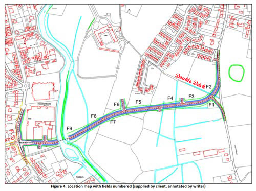
See also Road Design immediately hereunder. Note: the words ‘Double Ditch’ were placed on this map by Thurles.Info website and not by either author Mr F. Coyne or his client Tipperary Co. Council. The purpose of placing ‘Double Ditch’ on the map, here below is to demonstrate that the inner relief road will most likely impinge on the Great Famine Double Ditch in two places, see (1) between Field 4 (F4) and Field 3 (F3) and (2) between Field 3 (F3) and Field 2 (F2).
Note, the ‘Double Ditch’ itself is represented by the pale blue line running parallel with the printed words ‘Double Ditch’.
Planning Ref. No.: N/A
IG: 213211.375/158072.724
RMP: TN041-043
ÆGIS REF.: 210-11
Report Author: F. Coyne BA MIAI
Client: c/o Michael Devery, North Tipperary County Council,
Civic Offices, Nenagh, Co. Tipperary, Date: October 2013
1. Scope of Study.
This report identifies and assesses the potential direct and indirect impact(s), if any, on the potential archaeological environment of a proposed relief road in the townlands of Clongower and Monakeeba, Glebe and Mullauns, Thurles, Co. Tipperary.
This report fulfils the usual criteria of an archaeological impact assessment and follows the most recent EPA guidelines on the compilation of an EIS (2002; 2003). Pertinent guidelines published from time‐to‐time have also been consulted and are listed in the project references given at the back of this report. A brief historical introduction to the area is provided and archaeological features in the vicinity, including any standing remains, are discussed. The report details the potential archaeological and/or cultural heritage features on the site and in its vicinity and discusses the impacts, if any, of the development on that archaeology and/or cultural heritage.
No intrusive archaeological investigations (test‐trenching or excavation) have been undertaken at this stage or as part of this desktop assessment. However a geophysical assessment has been carried out under licence number 13R11 at the location of RMP TN041‐043‐‐‐ enclosure.
The site inspection on which this report is based was carried out on Wednesday 23rd October 2013.
2. Method of Study
The following resources and methods of establishing the archaeological status of the site of the stone quarry were used:
- The subject site was visited and inspected by a qualified archaeologist;
- The Record of Monuments and Places constraint maps and lists (RMP) and the sites and monuments record archive (SMR) were examined;
- A wide range of local historical and archaeological records relevant to the study area were consulted, including the Ordnance Survey First Edition six‐inch map (c.1840), the Ordnance Survey twenty‐five inch map and aerial views;
- Thurles and Environs Development Plan 2009‐2015;
- National Inventory of Architectural Heritage;
- Topographical Files held in the National Museum of Ireland;
- Archaeological Survey of Ireland files and publications;
- A review of any archaeological investigations in the vicinity was also undertaken.
3. Existing Environment
The subject site lies on the south‐eastern side of Thurles town, in an area of open fields through the
townlands of Clongower and Monakeeba, then along the roadway which is also the townland
boundary between Glebe and Monakeeba, and Mullauns and Monakeeba.
3.1 The Site Inspection
The subject site was inspected on Wednesday 23rd October 2013. Weather conditions were showery.
The subject site is a series of fields. For ease of reporting they were numbered in the direction in which they were walked, from east to west, (see figure below), and numbered F1 to F9.
The proposed road will run along Mill Road, past RMP TN41-044, before entering the green field area. [No mention of crossing a right of way or great famine Mass path, as clearly shown in Figure 4 above.]
Field 1 is a small field, covered in short grass and grazed by horses.
Field 2 is a large open grassy field, covered in short grass and grazed by horses.
Field 3 is a large open grassy field, covered in short grass and grazed by horses. It is very wet underfoot.
Field 4 is a large open grassy field, covered in short grass and grazed by horses. It is extremely wet underfoot.
Field 5 is a rectangular grassy field, located to the rear (south) of a housing estate. It is covered in short grass and grazed by horses. Mounds of rubble and topsoil are located at the eastern side of the field. Traces of cultivation ridges are to be seen throughout this field.
Field 6 is a large open grassy field, covered in short grass and grazed by cattle. It is located along a natural ridge which runs in a general north‐south direction, and is drier than the land to the east and west.
Field 7 is a large open grassy field, covered in short grass. It is located along a natural ridge which runs in a general north‐south direction, and is drier than the land to the east and west. The RMP TN041‐043 is located in this field along the crest of this ridge.
Field 8 slopes from a high at east to lower ground at west, where rushes grow in abundance, possibly marking an old pond area. Traces of an old field boundary, running in an east‐west direction was also noted in this field.
Field 9 contains several undulations, growths of rushes and is wet underfoot, and is adjacent to the river. It has the potential to contain previously unrecorded wetland archaeological sites, such as
fulachta fiadh. [Fulachta fiadh is the name given to one of many burned mounds, dating from the Bronze Age, found in Ireland.]
The eastern side of the proposed bridge will be located in this field.
The proposed road will cross the River Suir at the location of a new bridge. At the western side of the river, it will run through the car park area of an industrial estate, before joining with the Slievenamon Road.
No previously unrecorded archaeological monuments were recorded during the inspection.
The Archaeological Impact Statement then goes on to discuss protected structures within the town, including structures on Slievenamon Road, before declaring, “There are no protected structures located on the subject site.”
This online statement will now be emailed, yet again, to the revelant government authorities, in the hope of getting a reply.
Some small hope now does exist, Knagg family members world-wide are keenly following our progress, or lack of same.

Leave a Reply