The small Holly Blue butterfly is one of those bright, delicate insects that can be missed until it suddenly flashes pale blue in front of you. This one was spotted in Thurles, Co. Tipperary, drinking water from damp stones; a behaviour butterflies often use to take in moisture and dissolved minerals.
The Holly Blue Butterfly, (Celastrina argiolus). Picture: George Willoughby.
The Holly Blue, (Celastrina argiolus), is a small butterfly with a wingspan of about 2.6 – 3.4cm (1.02 -1.34 Inches approx). It is usually the first “blue” butterfly, that people see in spring, and it can appear again later in summer. Unlike the Common Blue, which is more often seen low over grassland, the Holly Blue tends to fly higher around hedges, shrubs, trees, gardens, parks and woodland edges. Its pale silvery-blue underside, marked with small black spots but no orange markings, is a useful identification feature.
So how rare is it in Co. Tipperary? Nationally, the Holly Blue is not considered threatened. The Irish Red List assessment lists it as Least Concern, describing it as common and widespread in Ireland, with evidence of spread in suburban habitats. However, that does not mean every sighting is ordinary at local level. In Tipperary, Holly Blues are present but still worth recording, especially because they can be easily overlooked as they move quickly through gardens and hedgerows. A recent Butterfly Conservation Ireland note describes the Holly Blue as a successful garden and woodland-edge species, seen in wooded parks, gardens, hedges and woodland, with a second generation often emerging in July.
Its success is closely linked to two familiar plants; namely holly and ivy. In spring, females lay eggs mainly on holly flower buds; later in the year, ivy becomes especially important for the summer generation. This is why mature hedges, old gardens, churchyards, woodland margins and ivy-covered walls can be surprisingly good places to find them.
The Thurles sighting is a lovely local record because it shows the species using an everyday urban or garden-edge habitat. Damp stones, puddles and wet paths can attract butterflies when they need moisture, particularly during warm weather. Leaving a little wildness helps: keep ivy where safe, allow holly to flower, avoid cutting all hedges at once, and grow nectar plants such as bramble, bugle, thistles and other native flowers. In short, the Holly Blue is not rare in Ireland overall, but a confirmed sighting in Thurles is still a valuable reminder that Co. Tipperary’s gardens, hedgerows and green spaces can support beautiful native butterflies.
Anyone who sees one should consider submitting the record to the National Biodiversity Data Centre, as local sightings help build a clearer picture of how this small blue butterfly is doing across the county.
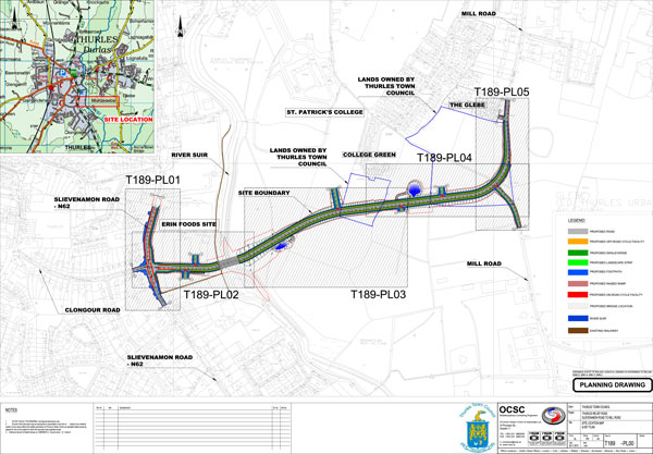
Thurles Inner Relief Road: New Tender Documents Raise Serious Questions Over Timelines, Political Claims and the Destruction of the Great Famine Double Ditch.
The publication of new tender documents for the Thurles Inner Relief Road has been presented as a significant milestone for a long-delayed project. In one sense, it is. After years of promises, updates and political announcements, Tipperary County Council has now gone to the market seeking engineering technical consultancy services to progress the scheme. But the detail contained in the newly published tender raises serious questions about the true timeline for delivery, the accuracy of previous political claims, and the destruction of the historic Great Famine “Double Ditch”, to facilitate a road that still appears to be years away from completion.
The official eTenders notice, published in July 2026, confirms that Tipperary County Council is seeking a multi-disciplinary technical consultancy team for the Thurles Inner Relief Road. The tender describes the work as including a review of existing documents, completion of outstanding deliverables for Stages 3 and 4, and preparation of deliverables through Stages 5 to 7. Crucially, the official notice gives the contract duration as 50 months.
That single figure changes the entire public understanding of this project. The proposed road is not simply waiting for diggers to arrive. Tipperary County Council’s own January 2026 management report described the scheme as an approximately 1.1km local link between the N62 and Mill Road, including a signalised junction at Slievenamon Road, a new priority junction with Mill Road, five intermediate access junctions, public lighting, flood alleviation works and a 50-metre tied bowstring arch crossing of the River Suir.
This is a substantial piece of infrastructure, and the new tender shows that major consultancy, design, approval, procurement, construction supervision, handover and defects processes still remain. The public therefore deserves honesty about the timeline. That honesty is especially important because previous political messaging now appears highly questionable. In November 2025, press reported that Deputy Mr Ryan O’Meara said Minister for Transport Mr Darragh O’Brien expected construction to commence on the Thurles Inner Relief Road the following year;2026. The same report quoted Deputy O’Meara as saying that Department of Transport officials had advised him the project should be completed and opened in approximately 24 months from then.
How does that claim stand beside a 50-month consultancy contract published in July 2026? If the tender process for the consultancy team is only now underway, and if that consultancy contract itself is expected to run for approximately 50 months, then completion by late 2027 is no longer credible. It is not enough to simply welcome “progress” while ignoring the contradiction. Deputy O’Meara should clarify exactly what he was told, by whom, and on what basis the public was led to believe that the road could be completed and opened in roughly two years.
This matters because Thurles people have heard promises about this project for far too long. Planning permission for the road was granted as far back as 2014, according to earlier press and local radio reporting. More than a decade later, the project is still moving through consultancy and design stages. Local frustration is understandable. But frustration should not be used as a cover for spin. Nor should the traffic needs of Thurles be used to brush aside the heritage loss already caused by this scheme.
The planned route has been linked for years by local campaigners and heritage advocates to the Great Famine “Double Ditch” at Mill Road. In 2020, Thurles.info publicly asked whether the planned Inner Relief Road would negatively affect what it described as the 1846 Thurles Double Ditch, a right of way and Mass Path associated locally with famine-era history. The warnings did not stop there. In February 2021, Thurles.info published commentary on an Archaeological Impact Statement, arguing that the proposed road would most likely impinge on the Great Famine Double Ditch in two locations. In March 2021, the same local outlet reported that Cllr Jim Ryan had confirmed the Double Ditch was to be destroyed to construct the Inner Relief Road. This was despite phone denials by Councillor Mr Micheál Lowry of the “Lowry Team”, who readers will remember inquired as to my standing in the community. {☺☺☺}
These are not minor matters. A famine-era pathway, Mass Path or heritage landscape is not just an inconvenience on a drawing. It is part of the physical memory of a town and its people. If warnings were made before destruction occurred, then the question must be asked clearly: why was the Double Ditch not protected, preserved, recorded more fully, or incorporated into the design?
Was every alternative route examined? Was the public given a full explanation? Was the heritage value properly weighed against the road design? Who decided that destruction was acceptable? And why is Thurles now being asked to accept the loss of a historic feature while the road itself may not be complete until around 2030 or later?
Nobody disputes that Thurles needs traffic solutions. The town has long suffered from congestion, poor circulation and pressure on its historic centre. A second river crossing and an improved link between Slievenamon Road and Mill Road may well bring benefits. But infrastructure should not be delivered through vague timelines, political overstatement and irreversible heritage loss. The publication of the new tender documents should therefore be treated as more than a procedural step. It should be treated as a moment of accountability.
Tipperary County Council should publish a clear and realistic delivery programme for the Thurles Inner Relief Road. Deputy Ryan O’Meara should explain the gap between his previously reported 24-month completion claim and the newly published 50-month consultancy timeline. The Council should also account for the treatment of the Great Famine Double Ditch, including what warnings were received, what assessments were carried out, and why destruction was permitted.
Thurles deserves roads. But it also deserves truth. It deserves progress, but not spin. And it deserves development that respects the town’s history rather than erasing it first and explaining later.
Irish Rail and Córas Iompair Éireann have brought High Court proceedings against Tipperary County Council in a dispute over a train signalling mast near the old Cahir railway station.
Irish Rail
The case centres on whether the mast, located about 130 metres from the old Cahir Rail Station, should be treated as exempted development or whether it affects the setting of a protected structure. The station, described in reports as a Gothic revival railway building dating from the 1850s, is at the heart of the planning disagreement.
Tipperary County Council served an enforcement notice in June 2026 under the Planning and Development Act 2000. That notice requires Irish Rail to cease using and remove the signalling mast by September 2026. Irish Rail is now asking the High Court to quash the council’s decision.
Irish Rail argues that the local authority made errors “in law and in fact” when deciding the mast was not exempted development. It also disputes the council’s view of the “curtilage”; the land or setting attached to a protected structure and says the mast is too far from the station building to fall within that protected area.
The rail operator further says it has installed more than 700 similar masts around Ireland without complaint from other planning authorities. It claims the protected status at the Cahir location now applies only to the station building, rather than other nearby railway structures previously listed in older development plans.
The council’s position is that the mast impacts the character and setting of the historic station. The matter is expected to return before the High Court on July 20th 2026.
Ireland’s latest greenhouse gas figures bring a welcome headline: emissions fell again in 2025. But behind that progress lies a much harder truth. The country is still nowhere near the pace of change required to meet its legally binding climate targets, and the next few years are likely to be far more difficult than the last few.
The Environmental Protection Agency’s provisional figures show that Ireland’s greenhouse gas emissions decreased by 2.2% in 2025, equivalent to 1.2 million tonnes of carbon dioxide equivalent. It was the fourth year in a row that emissions fell. Reductions were recorded across all main sectors, with the biggest falls in energy industries, buildings, industry and transport.
That is encouraging. It shows that emissions can fall while Ireland’s economy and population continue to grow. It also suggests that policy, investment and cleaner technology are beginning to have an effect.
But the scale of the challenge remains stark. Ireland’s national climate law requires a 51% reduction in greenhouse gas emissions by 2030 compared with 2018 levels. By 2025, emissions had fallen by only 14.5% when land use, land-use change and forestry are included. The EPA has warned that emissions must now fall by more than 10% every year to 2030 if Ireland is to meet its national climate target.
That is the central difficulty. A 2.2% annual fall is progress, but it is not enough. Ireland is moving in the right direction, yet not nearly fast enough. The easier gains may also be running out. The energy sector has delivered major reductions, helped by renewable electricity, less fossil-fuel generation and changes in the power system. Emissions from power generation and large industrial companies fell by 5.5% in 2025, according to the EPA. But future reductions will increasingly depend on harder-to-change parts of daily life: how people travel, how homes are heated, how farms produce food, how industry uses energy, and how quickly infrastructure can be built.
Transport is one of the biggest warning signs. Emissions fell in 2025, helped by more biofuel use and rising electricity consumption in road transport. But transport still exceeded its sectoral ceiling. This points to a deeper problem: Ireland is making improvements, but car dependency, slow public transport delivery, rising travel demand and freight emissions continue to make transport one of the most difficult sectors to decarbonise.
Industry faces similar pressure. Industrial emissions fell in 2025, but the sector still overshot its ceiling. Some reductions can come from fuel switching or lower fossil-fuel use, but long-term progress will require deeper changes in manufacturing, cement production, industrial heat and investment in cleaner processes. That will not be simple, cheap or quick.
Agriculture remains perhaps the most politically sensitive challenge. The 2025 fall in agricultural emissions was very small. Lower cattle numbers helped, but this was offset by increased fertiliser use and higher milk production. Agriculture is central to rural Ireland and the national economy, but it is also a major source of methane and nitrous oxide. Reducing these emissions at the speed required will involve difficult choices about land use, herd size, fertiliser, food production and farm incomes.
Buildings offer another mixed picture. Emissions fell in 2025, helped by a warmer winter and reduced fossil-fuel use. Residential emissions are now much lower than in previous decades. But warmer weather is not a climate policy. Lasting reductions will require faster retrofitting, more heat pumps, improved energy efficiency, skilled workers and financial supports that make upgrades realistic for households and businesses.
Ireland also faces a serious EU compliance challenge. Under the EU Effort Sharing Regulation, Ireland must reduce emissions in sectors such as agriculture, transport, buildings, waste and smaller industry by 42% by 2030compared with 2005. The EPA says Ireland is projected to miss that target, with a maximum projected reduction of 23% by 2030 even under a scenario with additional measures.
The cost of missing targets could be significant. Reuters reported that Ireland’s fiscal and climate watchdogs warned the State could face EU compliance costs ranging from €8 billion to €26 billion by 2030, if emissions-reduction plans are not delivered. That means failure would not simply be environmental. It could become a major financial burden on the public purse. There is a risk that one positive year creates a false sense of security. Falling emissions are welcome, but climate targets are not judged by headlines. They are judged by cumulative reductions, carbon budgets and legally binding limits. Ireland may be provisionally under its first carbon budget, but future budgets will be tighter and harder to meet.
The real test now is delivery. Targets have been set. Carbon budgets have been agreed. Sectoral ceilings have been created. The legal framework is in place. What Ireland needs next is faster implementation; more renewable power, stronger grids, cleaner transport, warmer homes, lower-emission farming, industrial investment and public policies that make low-carbon choices affordable and practical.
Ireland’s emissions are falling. That matters. But the road to 2030 is getting steeper, not easier.The 2025 figures should be welcomed, but they should not be mistaken for success. They are a reminder that progress has begun, and that the hardest work is still ahead.
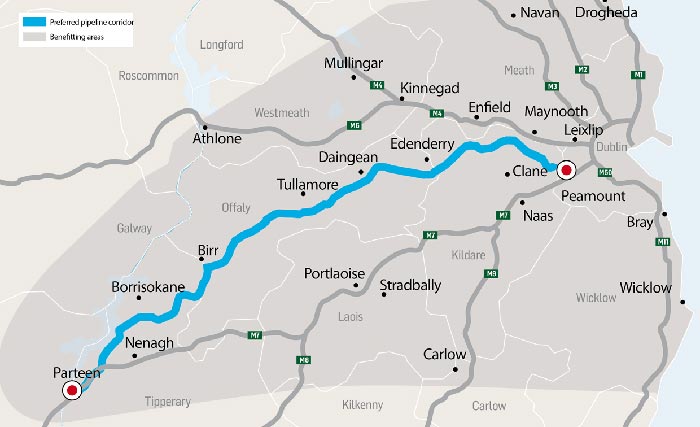
An Coimisiún Pleanála’s decision to push back its ruling on Uisce Éireann’s massive Shannon water abstraction project is not just a planning delay. From a Tipperary perspective, it is a crucial breathing space.
The proposed Water Supply Project for the Eastern and Midlands Region would see more than 300 million litres of water a day abstracted from the River Shannon at Parteen Basin, below Lough Derg, before being treated and piped across the country to serve the Midlands, the east and the Greater Dublin Area. It has been described as the largest water infrastructure project in the history of the State, with estimated costs in the region of €4.6 billion to €5.9 billion.
For communities in north Tipperary, this is not an abstract national infrastructure debate. The intake point is at Parteen Basin, and the project includes a major treatment plant close to the extraction point in Co Tipperary. That means local people are being asked to host the front end of a project whose main benefits will be felt far away, particularly in Dublin and the wider eastern region.
Uisce Éireann argues that the project is critical to providing a safe, secure and resilient water supply for up to 50% of the State’s population. It says planning permission has been lodged with An Coimisiún Pleanála and that the project is central to future housing, population growth and economic development. Those are serious national objectives, and nobody in Tipperary should dismiss the need for proper water planning.
But a project of this scale cannot be waved through simply because Dublin needs water. The Shannon is not just a line on an engineering map. It is an ecological, recreational, economic and cultural resource for Tipperary, Clare, Limerick, Galway, Offaly and many other communities along its course. Any long-term abstraction must be judged not only by what it delivers to the east, but by what it risks taking from the west and midlands.
The fact that 114 submissions have been made to An Coimisiún Pleanála shows the level of public concern. Environmental groups have warned about climate, ecological and sustainability risks, while business groups have urged approval on the basis of security of supply. That divide is exactly why the Commission is right to take more time.
The new decision deadline, now expected before July 2nd 2027, should be used properly. It should not become a procedural pause while the same assumptions remain in place. It must allow for deeper scrutiny of the project’s environmental impact, climate resilience, cost, alternatives, local consequences and long-term governance.
Tipperary needs clear answers. How will Lough Derg and the lower Shannon be protected during drought conditions? What guarantees will there be that abstraction levels will not damage habitats, fisheries, tourism or water quality? What permanent benefits will host communities receive? How will local voices be represented after construction begins? And what happens if the project costs rise beyond current estimates?
There must also be a fairer national conversation about water conservation. Before rural and regional communities are asked to carry the burden of supplying the east, the State must show that leakage reduction, demand management, rainwater harvesting, wastewater reuse and sustainable urban planning have been pursued with real urgency.
This delay is therefore welcome, not because Ireland does not need infrastructure, but because infrastructure must be done right. Tipperary should not be treated as the convenient source for a Dublin solution. The county has a legitimate stake in the future of the Shannon and deserves more than reassurances.
An Coimisiún Pleanála now has time to examine the evidence fully. Uisce Éireann has time to answer local concerns openly. Government has time to prove that this is part of a balanced national water strategy, not simply another example of regional resources being redirected towards the capital.
The Shannon belongs to the communities who live with it every day as much as it belongs to the State. If this project is to proceed, Tipperary must be heard, protected and respected from the very start.
This website uses cookies to improve your experience. We'll assume you're ok with this, but you can opt-out if you wish.AcceptRead More
Privacy & Cookies Policy
Privacy Overview
This website uses cookies to improve your experience while you navigate through the website. Out of these, the cookies that are categorized as necessary are stored on your browser as they are essential for the working of basic functionalities of the website. We also use third-party cookies that help us analyze and understand how you use this website. These cookies will be stored in your browser only with your consent. You also have the option to opt-out of these cookies. But opting out of some of these cookies may affect your browsing experience.
Necessary cookies are absolutely essential for the website to function properly. This category only includes cookies that ensures basic functionalities and security features of the website. These cookies do not store any personal information.
Any cookies that may not be particularly necessary for the website to function and is used specifically to collect user personal data via analytics, ads, other embedded contents are termed as non-necessary cookies. It is mandatory to procure user consent prior to running these cookies on your website.


Recent Comments