Local History Group Celebrates Littleton’s Bord na Móna Heritage.
The people, places and memories of Littleton’s peat industry will take centre stage at the book launch of “Bord na Móna: Littleton Story” in the Horse & Jockey Hotel, Thurles, on Friday, 25th September, at 8.00 pm.
Presented by the Moycarkey / Borris Littleton Men’s Shed and Community History Group, this local history publication celebrates the men and women whose working lives helped shape the community, preserving stories of the bogs, the machinery and a legacy that reaches far beyond the workplace. Former employees, their families and everyone with an interest in the area’s heritage are warmly invited to attend.
The Littleton Bog complex is a term used by the Moycarkey / Borris / Littleton Men’s Shed and Community History Group to outline the area of peatlands worked on an industrial scale by Bord na Móna since the company was founded in 1946. With the cessation of works at the the Littleton Briquette Factory and milled peat operations in April 2018, it brought to a close sixty-two years of peat extraction works at this area of peatlands.
This book, while not endeavouring to be an in-depth historical analysis of Bord na Móna operations in the middle of Tipperary; provides a snapshot of its impact on the parish of Moycarkey / Borris / Littleton. Other parishes in the area such as Moyne / Templetuohy; Gortnahoe / Glengoole and Killenaule also had very important roles in the growth and development of the bogs as areas of employment and add greatly to the overall story of the relevance and importance of Bord na Móna to these communities. People from Thurles and other surrounding parishes were also employed on the bog or in the briquette factory. Indeed, it must also be recognised that the site of Littleton Briquette Factory is in the townland of Killeens, which is part of Killenaule parish.
This booklet gives a brief overview of the turf cutting operations at the outset of the development of the bogs, with the main focus being on the offices and yard at Ballybeg. This new industry meant that many men were required to get operations up and running, with the result that several of these came from outside Tipperary, many of whom resided in a billet camp, which was sited across the road from the main office and yard. It is not meant to be an exhaustive account of the work which took place in the Littleton Bog complex or within the area of work associated with the briquette factory. For a comprehensive overview of the history of Bord na Móna readers are encouraged to read Brown Gold: (A History of Bord na Móna and the Irish Peat Industry by Donal Clarke).
The type of work engaged on the bogs is explored, as is a brief exploration of the various machines which were required to work the bogs on such an industrial scale. Coupled with the influx of workers and families was a need for social housing and this is also chronicled with an overview of housing schemes, school development and an associated impact on sporting and social organisations across the parish.
It is also recognised that the peatlands of mid-Tipperary have a rich and vibrant history, which have engaged all peoples across the generations. A sample overview of the flora and fauna of the bogs, its relevance as a carbon sink in the modern era and how the rich tapestry of its past can be used to educate and inform people as the impact of climate change is felt locally and globally.
Many parts of the bog were given local place names, which were readily identifiable to the Bord na Móna workers. Many of these are also recorded so that this local knowledge is not lost and can continue as part of the vibrant folklore associated with a lifetime for many of working on the bogs.
Lastly, an overview of archaeological finds in the bog, both before and during Bord na Móna operations are also recorded. These assist in demonstrating the relevance of the bogs as spiritual, votive, social, energy and recreational areas, which are all intertwined across the generations.
Acknowledgments The Moycarkey Borris Littleton Men’s Shed and Community History Group are thankful to everyone who assisted with this Bord na Móna story in the parish community. To those who supplied articles and photographs: Colm Dempsey BnM, Ray Yates, Tommy Maguire, Frank Connolly, Liam Dempsey, Fr. Tomás O’Connell, Christy Bracken, Ann Slattery, Billy Loughnane, Peggy Kirby, Billy Ryan, M. Skehan Ruddy, Tom Kelly, Ed. O’Shea, Sean Ryan, Sadie Dwyer, John O’Loughlin, Martin Cooney and members of the group who also contributed articles. A special word of thanks to Clare McNamara, Image Library Officer, National Museum of Ireland for her support and for the kind permission of the National Museum to reproduce images of some items discovered in the Littleton Bog Complex. Thanks to Dr. Charles Mount for his kind permission to reproduce a ‘Togher/Tocher’ (wooden trackway), following excavation at Longfordpass. The MBL Men’s Shed and Community History Group are Michael Dempsey, Jim Flanagan, Seamus Bourke, John Fogarty, Liam O’Donnchú, Mary Ryan, Mary and Frank O’Regan, Billy Purcell, Joe Moran and Pat Bracken. Thanks also to Tommy Britton for his support and a special word of thanks to Bernie Lonergan who co-ordinated the project at the outset.
Dedication This overview of the impact of the bogs of mid-Tipperary on the community of Moycarkey / Borris / Littleton could not have been possible without telling some of the stories of the life and times of the men and women who worked in the Littleton Bog complex under the employment of Bord na Móna. This booklet is dedicated to all these people, and to the legacy which they have left behind. To those still living, we salute and thank you. To those who have gone to their eternal reward; Ar dheis dé go raibh a n-anamacha. (Irish translation – “May their souls be on the right hand of God”).
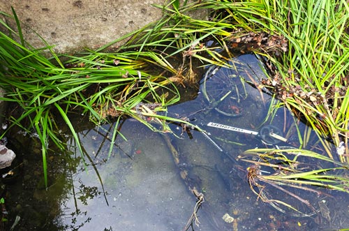
Anyone looking for a ride in Thurles, tonight, then an unwanted, submerged Crossway Merida bicycle could be your best bet.
Local wildlife was left baffled this week after a bicycle was discovered taking an unscheduled bath in the River Suir.
The bike, believed to be a Crossway Merida variety, was found lying beneath the water with all the dignity of a cyclist who had confidently shouted, “Watch this!” moments before disaster. As yet no body has been located.
Competition – Spot the Bike. Pic: G. Willoughby.
Witnesses say the bicycle may have entered the river after misunderstanding Ireland’s new transport policy. “It heard everyone talking about greener travel,” one duck explained, “and apparently decided to join the actual green overgrown rush bed.”
The River Suir is already famous for its salmon and brown trout. Now it can add mountain bikes to the list, although anglers are reminded that bicycles must be returned to the water if they are under eighteen gears. Fishing in Ireland has yet to confirm the correct bait, but experts recommend using a fluorescent jacket and shouting, “Who left this here?” The bicycle itself declined to comment, although one wheel appeared distinctly tired. Its chain is reportedly rusty, its brakes are feeling pressured, and the saddle has requested immediate relocation to somewhere less damp.
Thurles Municipal Council officials and local Councillors are considering several explanations; illegal dumping, a dramatic relationship breakup, or an ambitious attempt to cycle directly to France without paying ferry charges. Environmental campaigners “Refresh Thurles” have stressed that rivers are no place for unwanted bicycles. Anyone wishing to dispose of an old bike should use a proper recycling facility, or give it to someone who promises not to test whether it can swim.
At press time, and for several months previous the bicycle has remained submerged at low tide, awaiting rescue, repair, and a very stern lecture about not wearing its water wings.
Now with public transport prices being increased by 15% from January, an immediate rescue could be advantageous.
Most of Cabragh Road in Thurles was resurfaced over the past week, following the deterioration and collapse of sections of the road surface after water-service works were carried out some years ago.
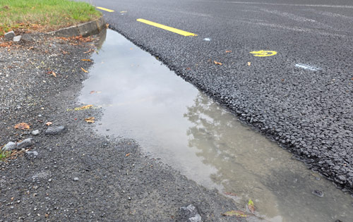
Much of the new surface appears to have been finished to a good standard. However, several sections near homes and businesses; including the area entrance to O’Meara Oil, now appear to be incomplete and potentially hazardous.
As our photographs show, the newly laid asphalt ends in a rough, abrupt and raised edge beside an uneven pedestrian margin. Anyone walking out from town may suddenly encounter a section where the resurfacing covers only part of the available roadside space.
Pic: G. Willoughby.
This presents particular difficulties for:
► wheelchair and mobility-scooter users; ► parents pushing children in buggies; ► people using walking aids; ► older pedestrians and those with impaired balance; ► cyclists moving close to the road edge; and ► residents entering or leaving adjoining properties.
Small wheelchair castors or buggy wheels could catch against the raised lip or loose stone. A pedestrian attempting to avoid the uneven surface could also be forced closer to moving traffic.
Pic: G. Willoughby.
The unfinished edge may create further problems if it is not corrected promptly. Water could collect along the change in level instead of draining freely, increasing the risk of puddles, splashing and deterioration. Water entering an unsealed pavement edge can weaken it, while passing traffic may loosen the exposed aggregate and cause the asphalt to ravel or break away progressively.
The resulting loose stones could become an additional slipping or skidding hazard. Repeated vehicle loading may also widen the damaged edge, leaving potholes, crumbling margins and an even greater difference in level.
Pic: G. Willoughby.
Serious questions therefore arise: Why were these sections left at a different level? Was pedestrian and wheelchair access assessed before the work was accepted? Were drainage and connections to entrances properly examined? Has the resurfacing received a final inspection? Is the contractor expected to return and complete the margins?
Fresh road markings and a new running surface do not make a project complete if unsafe edges remain beside homes, businesses and pedestrian routes.
These locations should now be inspected urgently by Tipperary County Council, made safe without delay and brought to a properly finished, accessible and well-drained standard. The council provides an official service for reporting damaged roads and footpaths, including an online “Fix-it”facility, [which today same consultation portal, despite every attempt, refused access].
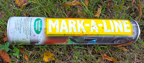
Which begs another question; Where have “Refresh Thurles” members vanished to? Note: Refresh Thurles members have failed to note that those working on this re-surfacing project, forgot to take their litter with them.
The public should not have to wait until somebody falls, a wheelchair becomes trapped or the newly laid surface begins to disintegrate before action is taken.
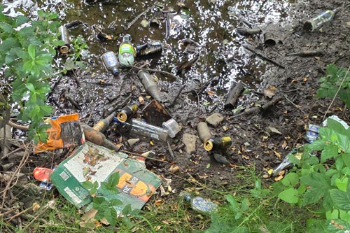
The Stench of Neglect: River Suir in Thurles Suffocates in Waste.
A Waterway Left to Fester: Apparent Pollution, Institutional Neglect and an Inexcusable Failure to Act.
The early images in the video immediately below are visually consistent with sewage-contaminated water, inadequately treated wastewater, detergent-bearing grey-water, or another organic effluent. The foam could indicate surfactants, while the grey colour and sludge may indicate suspended solids and decomposing organic matter. It does not resemble clean surface-water run-off.
However, a photograph alone cannot conclusively identify the slowly flowing substance in a river now almost static. Proper investigation should include samples from the suspected discharge point and locations upstream and downstream. Relevant analyses include dissolved oxygen, BOD, COD, ammonia, orthophosphate, suspended solids, E. coli, conductivity and surfactants. EPA material confirms that BOD, dissolved oxygen, ammonia, nitrate and phosphorus are central indicators of organic contamination, and that pollution-incident sampling should cover downstream, discharge-point and upstream locations.EPA sampling procedure
This slide-show above, however, presents a disgusting and deeply alarming picture; grey, foaming liquid and foul-looking sludge accumulating in what should be a living watercourse. Its exact composition must now be determined by laboratory testing, but its visible condition is wholly incompatible with the clean, healthy river environment the public is entitled to expect.
This river is neither a sewer nor a dumping ground. If analysis confirms an unlawful discharge, its source must be stopped, the damage remediated and every available enforcement power used.
Continued neglect after documented notification would be indefensible, a betrayal of the waterway, its wildlife and the community these authorities and representatives are supposed to serve.
Reminder
We can confirm that the above public meeting will take place, as stated above.
Thirteen years of warnings As stated in a recent post on Thurles.Info, the deterioration of the River Suir cannot credibly be described as “sudden” or “unforeseeable”. For more than a decade, residents, anglers and environmental campaigners have raised concerns about pollution, excessive vegetation, restricted flow, sediment, litter and neglect. These concerns were documented in “River Suir Crisis—Thirteen Years of Warnings, But Still No Coordinated Action”.
Now, 13 yearslater; the Minister of State Mr Kevin “Boxer” Moran recently visited sections of the Suir in Thurles and Holycross following representations from Independent TD Michael Lowry. It was stated that the Office of Public Works would support an application by Tipperary County Council under the enhanced Minor Flood Mitigation Works Scheme. However, I can confirm from recent discussions with varying responsible bodies, that they are not aware of any recent communication. Support for an application is welcome, but it is not a restoration programme. The public has not been shown the precise work proposed, the scientific evidence supporting it, the environmental assessments required, the anticipated cost and timetable or the body responsible for delivery and monitoring.
Political videos, visits and announcements by politicians and councillors cannot substitute for accountable work. Councillor Micheál Lowry, Deputy Michael Lowry and every other representative addressing the issue must be judged by measurable results. The same standard must apply to Tipperary County Council officials. [ Which begs the question; “Where were all the other local elected councillors when a recent promotional video, capturedby Mr Lowry TD, was uploaded unto social media.” ]
The missing ingredient for the River Suir is not more talk, it is delivery.We need clear answers:
► What works will be carried out? ► When will they begin? ► Who is responsible for delivery? ► Has the funding application now been submitted? ► What section of the river will be prioritised first? ► How will pollution and damaging discharges be reduced? ► How will progress be measured and reported publicly?
Approximately 150 fish, mostly brown trout, have died in a stretch of the River Suir in the Templemore area.
The incident is understood to have been discovered around August 10th, 2026 during the week ending August 12th, 2026, reportedly by a staff member of the River Basin Management Service, latter the organisation formerly known as the Local Authority Waters Programme, or LAWPRO. The change of name is confirmed HERE.
At the time of writing, no official report establishing the cause of the deaths has been published. However, an initial examination reportedly suggested that the fish may have died from oxygen depletion, same associated with extensive aquatic vegetation and restricted flow. Dense reed growth is clearly visible along sections of the upper Suir, including from Barry’s Bridge in the heart of Thurles town centre. Nevertheless, visible vegetation does not prove what killed the fish.
The public requires evidence; dissolved-oxygen records, water and fish sample results, the extent of the affected stretch and an assessment of any pollution, temperature, flow or habitat factors.
Could dense vegetation deplete oxygen? It is scientifically plausible that excessive aquatic growth could contribute to dangerously low dissolved-oxygen levels. Plants, algae and microorganisms respire continuously, consuming oxygen. During daylight, photosynthesis can replace or exceed that consumption. At night, photosynthesis stops while respiration continues, causing dissolved oxygen to fall. Surveys undertaken confirms that plant, microbial and algal respiration reduces dissolved oxygen at night, while daylight photosynthesis increases it.
The risk is greatest where vegetation is abundant and the water is warm, shallow, slow-moving or stagnant. Dense growth can restrict mixing, while bacteria and fungi decomposing dead plant material consume additional oxygen, as observed when Thurles Municipal District undertook the strimming of rushes last year, leaving same in the water to rot. Warm water also holds less dissolved oxygen.
We can confirm that the above public meeting will take place, as stated above. Perhaps Minister of StateMr Kevin Moran, Independent TD Mr Michael Lowry, together withCouncillor Mr Micheál Lowry should receive invitations.
The US Environmental Protection Agency identifies excessive plant growth, nighttime respiration, decomposition, high temperatures and reduced flow as possible contributors to oxygen depletion. Emergent reeds can transport atmospheric oxygen through their stems, so their direct withdrawal of oxygen from the water may be less significant than that of submerged vegetation or algae. A dense reed bed may still create locally oxygen-poor conditions by slowing the flow and trapping decomposing organic material.
A healthy, fast-flowing river is continually re-aerated by turbulence. If oxygen depletion caused this fish kill, the investigation must determine what combination of vegetation, nutrient enrichment, low flow, temperature and decomposition produced it.
Testing must occur at the correct timeand a single daytime oxygen reading would be inadequate. Dissolved oxygen generally reaches its lowest level shortly before sunrise, following a night of respiration without photosynthesis. Monitoring should therefore be continuous or conducted immediately before dawn. Measurements should be taken inside dense vegetation, in nearby open water and both upstream and downstream. Temperature, flow, pH, weather conditions and readings close to the sediment should also be recorded.
Salmonids, including brown trout, are particularly sensitive to low oxygen. The investigation must establish whether oxygen depletion caused this incident rather than merely presenting it as a possibility.
Thirteen years of warnings As stated in a recent post on Thurles.Info, the deterioration of the River Suir cannot credibly be described as sudden or unforeseeable. For more than a decade, residents, anglers and environmental campaigners have raised concerns about pollution, excessive vegetation, restricted flow, sediment, litter and neglect. These concerns were documented in “River Suir Crisis—Thirteen Years of Warnings, But Still No Coordinated Action”.
Section ofUpper River Suir, viewed from Thurles Park in the heart of Thurles town centre, last week. Picture: G. Willoughby
13 years to late; the Minister of State Mr Kevin “Boxer” Moran recently visited sections of the Suir in Thurles and Holycross following representations from Independent TD Michael Lowry. It was stated that the Office of Public Works would support an application by Tipperary County Council under the enhanced Minor Flood Mitigation Works Scheme. Support for an application is welcome, but it is not a restoration programme. The public has not been shown the precise work proposed, the scientific evidence supporting it, the environmental assessments required, the anticipated cost and timetable or the body responsible for delivery and monitoring.
Political videos, visits and announcements cannot substitute for accountable work. Councillor Micheál Lowry, Deputy Michael Lowry and every other representative addressing the issue must be judged by measurable results. The same standard must apply to Tipperary County Council.
Reeds may be a symptom-not the underlying cause. The problem cannot be reduced to reeds, bulrushes or appearance. Previous catchment assessments have identified excess phosphorus from sources including wastewater, animal waste and fertilisers as a significant pressure. Nutrient enrichment can encourage excessive plant growth, while respiration and decomposition may subsequently reduce oxygen.
Low summer flows, high temperatures, pollution, sediment, obstructions and vegetation may interact. Removing reeds without identifying why they proliferated risks treating a symptom, while leaving the underlying causes untouched. Clearance without ecological assessment could also damage habitat or transfer problems downstream.
Any intervention must therefore be based on catchment science and agreed with the relevant environmental and fisheries authorities.
Too many agencies and too little accountability
Responsibility is divided among Tipperary County Council, the River Basin Management Service, Inland Fisheries Ireland, the EPA, the OPW, Uisce Éireann, the National Parks and Wildlife Service, Landowners and Angling organisations. That complexity cannot provide cover for delay or buck-passing.
The public should now be told:
which organisation is leading the investigation;
when and where the fish were discovered;
how many fish and species were affected;
when oxygen, temperature and flow were measured;
what samples were collected;
whether pollution sources were investigated;
when laboratory results will be available;
and which agency will publish the findings.
Community initiatives, including proposals to remove bulrushes or establish a River Suir trust, may make a valuable contribution. However, volunteers and anglers cannot be expected to replace statutory responsibility.
Publish the findings This fish kill must mark a turning point. The responsible agencies should provide a published scientific assessment, laboratory and monitoring results, continuous oxygen and temperature monitoring at vulnerable locations, investigation of pollution and nutrient sources, an environmentally assessed vegetation-management programme and a costed river restoration plan.
Responsibilities, deadlines and progress reports must be made public. The cause of this fish kill should not be prejudged; but uncertainty cannot become an excuse for inaction. After thirteen years of warnings, the questions are who will take responsibility, what the evidence shows and how quickly a credible recovery programme will begin.
This website uses cookies to improve your experience. We'll assume you're ok with this, but you can opt-out if you wish.AcceptRead More
Privacy & Cookies Policy
Privacy Overview
This website uses cookies to improve your experience while you navigate through the website. Out of these, the cookies that are categorized as necessary are stored on your browser as they are essential for the working of basic functionalities of the website. We also use third-party cookies that help us analyze and understand how you use this website. These cookies will be stored in your browser only with your consent. You also have the option to opt-out of these cookies. But opting out of some of these cookies may affect your browsing experience.
Necessary cookies are absolutely essential for the website to function properly. This category only includes cookies that ensures basic functionalities and security features of the website. These cookies do not store any personal information.
Any cookies that may not be particularly necessary for the website to function and is used specifically to collect user personal data via analytics, ads, other embedded contents are termed as non-necessary cookies. It is mandatory to procure user consent prior to running these cookies on your website.







Recent Comments