Hereunder is a quote on the website run by the National Monuments Service.
“The National Monuments Service is reliant on landowners and the general public in fulfilling its role in the protection and preservation of our archaeological heritage and the assistance of the public is gratefully appreciated.”
“If you wish to report possible damage to a monument please contact the National Monuments Service by phoning 01 8882000 or e-mailing nationalmonuments@chg.gov.ie as soon as possible.”
This statement of encouragement by “The National Monuments Service” (a government body), can be viewed HERE.
Having been ignored by this very same government body, together with TD’s responsible for their sloppy operations, namely Mr Malcolm Noonan (Green Party) and Mr Darragh O’Brien (Fianna Fáil) for well over 12 months, I phoned their National Monuments Service offices today to be told that Tel: No. 01-8882000 was incorrect and that I should phone 01-8883200.
Having explained the issue for the umpteenth time to this department, on this occasion I was informed that “The National Monuments Service, were only interested in monuments which were 200 or more years old”.
I pointed out that the home of Michael Joseph O’Rahilly, known as ‘The O’Rahilly’, the only leader of the 1916 Rising to die in battle, had been reduced to rubble by developers Derryroe Ltd, in October of 2020. This same house, (like our Thurles, Great Famine Double Ditch) which also was not on the Record of Protected Structures (RPS) and had not any statutory conservation designations, was built in 1907. (61 years after the Thurles Great Famine Double Ditch project).
Unlike Thurles town, in the Michael Joseph O’Rahilly case, same were supported by Councillors, heritage groups, relatives of 1916 leaders, RTE TV and Radio, including O’Rahilly’s grandson Proinsias Ó Rathaille. The house was demolished on September 29th 2020 and one wonders was the case dealt with by the same individual I dealt with today, who informed me that ‘The O’Rahilly’ house “had history”. We ask the question are the National Monuments Service responsible for the loss of the ‘The O’Rahillyhouse’ and its huge historical significance.
Then came his joke of the century, “Write to Mr Michael Lowry TD or Mr Jackie Cahill TD, your public representatives”.
———————————————————————————
I now print hereunder, for the first time, relevant extracts from the Archaeological Impact Statement on the Great Famine Double Ditch, In Thurles.
I ask, please tell me, in case I have missed them, if in this Archaeological Impact Statement, you can find the words ‘Double Ditch’, ‘Mass Path’, ‘Public Right of Way’, or ‘Great Famine hunger relief project’? Despite its existence (see video above and historical evidence presented to date on Thurles.info) the Archaeological Impact Statement on this area makes no reference to the Double Ditch, despite Mr Coyne claiming he walked the fields which actually sandwich the ‘Double Ditch’.
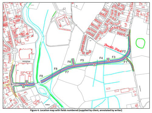
See also Road Design immediately hereunder. Note: the words ‘Double Ditch’ were placed on this map by Thurles.Info website and not by either author Mr F. Coyne or his client Tipperary Co. Council. The purpose of placing ‘Double Ditch’ on the map, here below is to demonstrate that the inner relief road will most likely impinge on the Great Famine Double Ditch in two places, see (1) between Field 4 (F4) and Field 3 (F3) and (2) between Field 3 (F3) and Field 2(F2). Note, the ‘Double Ditch’ itself is represented by the pale blue line running parallel with the printed words ‘Double Ditch’.
Figure 4, pictured above as stated, was ‘annotated by writer‘, meaning that notes were added to the diagram, giving explanation or comment. Same annotation was not supplied by Tipperary Co. Council.
Report Author: F. Coyne BA MIAI Client: c/o Michael Devery, North Tipperary County Council, Civic Offices, Nenagh, Co. Tipperary, Date: October 2013
1. Scope of Study. This report identifies and assesses the potential direct and indirect impact(s), if any, on the potential archaeological environment of a proposed relief road in the townlands of Clongower and Monakeeba, Glebe and Mullauns, Thurles, Co. Tipperary. This report fulfils the usual criteria of an archaeological impact assessment and follows the most recent EPA guidelines on the compilation of an EIS (2002; 2003). Pertinent guidelines published from time‐to‐time have also been consulted and are listed in the project references given at the back of this report. A brief historical introduction to the area is provided and archaeological features in the vicinity, including any standing remains, are discussed. The report details the potential archaeological and/or cultural heritage features on the site and in its vicinity and discusses the impacts, if any, of the development on that archaeology and/or cultural heritage. No intrusive archaeological investigations (test‐trenching or excavation) have been undertaken at this stage or as part of this desktop assessment. However a geophysical assessment has been carried out under licence number 13R11 at the location of RMP TN041‐043‐‐‐ enclosure. The site inspection on which this report is based was carried out on Wednesday 23rd October 2013.
2. Method of Study The following resources and methods of establishing the archaeological status of the site of the stone quarry were used:
The subject site was visited and inspected by a qualified archaeologist;
The Record of Monuments and Places constraint maps and lists (RMP) and the sites and monuments record archive (SMR) were examined;
A wide range of local historical and archaeological records relevant to the study area were consulted, including the Ordnance Survey First Edition six‐inch map (c.1840), the Ordnance Survey twenty‐five inch map and aerial views;
Thurles and Environs Development Plan 2009‐2015;
National Inventory of Architectural Heritage;
Topographical Files held in the National Museum of Ireland;
Archaeological Survey of Ireland files and publications;
A review of any archaeological investigations in the vicinity was also undertaken.
3. Existing Environment The subject site lies on the south‐eastern side of Thurles town, in an area of open fields through the townlands of Clongower and Monakeeba, then along the roadway which is also the townland boundary between Glebe and Monakeeba, and Mullauns and Monakeeba.
3.1 The Site Inspection The subject site was inspected on Wednesday 23rd October 2013. Weather conditions were showery. The subject site is a series of fields. For ease of reporting they were numbered in the direction in which they were walked, from east to west, (see figure below), and numbered F1 to F9.
The proposed road will run along Mill Road, past RMP TN41-044, before entering the green field area. [No mention of crossing a right of way or great famine Mass path, as clearly shown in Figure 4 above.]
Field 1 is a small field, covered in short grass and grazed by horses. Field 2 is a large open grassy field, covered in short grass and grazed by horses. Field 3 is a large open grassy field, covered in short grass and grazed by horses. It is very wet underfoot. Field 4 is a large open grassy field, covered in short grass and grazed by horses. It is extremely wet underfoot. Field 5 is a rectangular grassy field, located to the rear (south) of a housing estate. It is covered in short grass and grazed by horses. Mounds of rubble and topsoil are located at the eastern side of the field. Traces of cultivation ridges are to be seen throughout this field. Field 6 is a large open grassy field, covered in short grass and grazed by cattle. It is located along a natural ridge which runs in a general north‐south direction, and is drier than the land to the east and west. Field 7 is a large open grassy field, covered in short grass. It is located along a natural ridge which runs in a general north‐south direction, and is drier than the land to the east and west. The RMP TN041‐043 is located in this field along the crest of this ridge. Field 8 slopes from a high at east to lower ground at west, where rushes grow in abundance, possibly marking an old pond area. Traces of an old field boundary, running in an east‐west direction was also noted in this field. Field 9 contains several undulations, growths of rushes and is wet underfoot, and is adjacent to the river. It has the potential to contain previously unrecorded wetland archaeological sites, such as fulachta fiadh. [Fulachta fiadh is the name given to one of many burned mounds, dating from the Bronze Age, found in Ireland.] The eastern side of the proposed bridge will be located in this field. The proposed road will cross the River Suir at the location of a new bridge. At the western side of the river, it will run through the car park area of an industrial estate, before joining with the Slievenamon Road.
No previously unrecorded archaeological monuments were recorded during the inspection.
The Archaeological Impact Statement then goes on to discuss protected structures within the town, including structures on Slievenamon Road, before declaring, “There are no protected structures located on the subject site.”
This online statement will now be emailed, yet again, to the revelant government authorities, in the hope of getting a reply.
Some small hope now does exist, Knagg family members world-wide are keenly following our progress, or lack of same.
Only YOU and you alone can stop the current chain of virus transmission.
The Department of Health have confirmed that there have, sadly, been 28 further deaths caused by the Covid-19 pandemic; leaving the overall death toll, here in the Republic of Ireland, remaining at 4,109.
There have been 763 new additional virus cases reported within the republic today, or 11,759 in the past 14 days. This leaves the current total number of confirmed cases, since conception, here in the Irish Republic, at 213,400.
Relative to midnight last night, (February 18th), 7 further cases of Covid-19 were confirmed over the previous 24 hours, here in Co. Tipperary, with 241 cases identified within the same area; within the past 14 days.
Of the cases today; 251 are in Dublin, 84 in Galway, 57 in Kildare, 47 in Limerick, 42 in Waterford, with the remaining 282 cases located across all other counties.
There are 754 people with Covid-19 in hospital, and of that number, 151 are in ICU’s, according to Ireland’s COVID-19 Data Hub.
Some 7,950 fines have been issued by Gardaí to persons in breach of Covid-19 restrictions, with over 6,297 x €100 of these issued for non-essential travel and 263 x €500 for non-essential journeys abroad. Some 155 x €80 fines have been issued for refusal to wear face coverings.
The total world wide number of cases identified up to 5:30pm this evening, are now standing at almost 110.5 million confirmed cases, with global deaths well over 2.44 million.
Only YOU and you alone can stop the current chain of virus transmission.
The Department of Health have confirmed that there have, sadly, been 47 further deaths caused by the Covid-19 pandemic; leaving the overall death toll, here in the Republic of Ireland, remaining at 4,082.
There have been 901 new additional virus cases reported within the republic today, or 12,042 in the past 14 days. This leaves the current total number of confirmed cases, since conception, here in the Irish Republic, at 212,647.
Relative to midnight last night, (February 17th), 19 further cases of Covid-19 were confirmed over the previous 24 hours, here in Co. Tipperary, with 240 cases identified within the same area; within the past 14 days.
Of the cases today; 437 are in Dublin, 49 in Limerick, 43 in Galway, 39 in Kildare, 32 in Meath, with the remaining 301 cases located across all other counties.
There are 771 people with Covid-19 in hospital, and of that number, 151 are in ICU’s, according to Ireland’s COVID-19 Data Hub.
In Northern Ireland, sadly, 6 further people have died from Covid-19, with 297 new confirmed cases today. Meanwhile Northern Ireland’s lockdown has been extended to April, but some primary school pupils will return to class on March 8th next.
The Vatican has informed their employees that they may risk losing their jobs if they refuse to get a Covid-19 vaccination ,without legitimate health reasons. Getting vaccinated they stated was the responsible choice, because of the risk of harming others.
HSE Chief Executive Mr Paul Reid has confirmed that Ireland is on track to deliver 80,000 vaccinations this week.
Some 182,193 first doses of Covid-19 vaccines were administered by the Health Service Executive (HSE) here in Ireland up to February 15th, with 98,388 having received their second dose.
EU Commissioner for Ireland, Ms Mairead McGuinness, has stated that the Commission is hopeful that the Johnson & Johnson Covid-19 vaccine will be approved shortly, and that 200 million doses on order for EU states, should see Ireland receiving some 2.2 million doses.
The total world wide number of cases identified up to 5:30pm this evening, are now standing at well over 110 million confirmed cases, with global deaths well over 2.43million.
The planning application by Ryan Cleaning Event Specialists Ltd, for a 24,500 tonnes, per annum, waste facility, close to an already granted 5,000 ton facility, both to be located at Cabragh Business Park in Thurles, can now be viewed in detail.
Click HERE to view in full and having opened the online page: – Next – Go to pale green tab centre marked ‘View scanned files.’ Next – Click on box centre of uploaded page, marked ‘I Agree‘ and then click on ‘View Files‘. View the relevant Planning Application data, by clicking on the various blue ‘JPEG View‘ links right of image.
Do remember that the file number assigned to this planning application is 21158.
Planning Application States.
Development Address: Cabragh Business Park, Ballycurrane, Thurles, Co. Tipperary.
a) a single storey material recovery and transfer facility building (of floor area 1031 m sq). b) a single storage detached prefabricated office building (floor area 60 m sq) with signage on both buildings. c) vehicular access to the site is via the as constructed existing entrance. d) a service yard with vehicle weighbridge and vehicle washing area with the site. e) on-site staff and visitor car parking and truck parking areas. f) all necessary ancillary site development works to facilitate this development with boundary treatment and landscaping. g) all associated site works consisting of petrol interceptor and silt traps and connection to existing septic tank and upgraded percolation area with all associated site works (the application relates to an activity requiring a waste facility permit from Tipperary County Council, the waste tonnage for acceptance and handling at the facility will not exceed 24,500 tonnes per annum).
For the many angry local residents, with young families, now residing and paying heavy mortgages; who have contacted Thurles.Info, and who are living in the immediate area of the Cabragh Business Park; you can find more information on the planning application process, by visiting HERE.
It is expected that local councillors (especially those with a financial interest), will support this planning application, thus turning Thurles into a dumping ground, with waste from neighbouring counties being dragged through and stored in the centre of a residential area.
Residents should now write to both local TD’s, namely Mr Lowry / Mr Cahill and to all Thurles Municipal District Councillors asking: – (A) Do they hold any financial interest in either dump, present or purposed, within the Cabragh Business Park venue, which we understand is also being used temporarily, by yet another independent recycling group, namely Ryan Brothers, Mill Road? (B) Will they commit to opposing any other such planning licence, now and into the future?
We here at Thurles.Info first joked about this issue, on September 17th, 2018. Well what else can you do when you are dealing with employees who have little or no regard for the spending of local taxpayer’s money. Worse still, taxpayers themselves appear not to care how their money is spent by these same employees.
Junction Clongour Road & Slievenamon Road.
We further discussed the same subject again, more seriously, on December 5th, 2018.
Now, yesterday, February 16th 2021, (almost 2.5 years after we brought it to our readers attention) and after thousands in tax payer’s money, was spent on this same area, in replacing plastic bollards, etc, etc, etc, a Thurles Municipal District councillor is only now calling for it to be realigned.
First however, as stated in this councillors request, make no mistake, these were never safety bollards to protect pedestrians, rather delicate plastic tubing. Note also, this newly created green area was never, despite being used as such, intended to be a footpath.
This green muddied area shown in picture above, was once a cycle lane, introduced by Labour Party TD Mr Alan Kelly, in the hope of picking up a few stray votes, days prior to a General Election.
Since the cycle lane was first introduced, same, due to a lack of parking spaces, continuously remains blocked by resident’s vehicles, all justifiably in need of parking spaces.
Fianna Fáil Cllr. Mr Seamus Hanafin yesterday has at last called for the junction between Clongour Road and Slievenamon Road, in Thurles, to be properly re-aligned, to allow after 2.5 years, large trucks to turn, rather than block busy rear following traffic.
The re-alignment work carried out at this junction back in Mid-2018, made this junction almost 4 metres narrower. Same has resulted in making life extremely difficult for both 18 wheeler delivery trucks and cattle truck drivers, latter attempting to stay in their lane, while manipulating the corner onto Clongour Road. From the images above and left, drivers have to mount the kerbs with their vehicles, thus damaging plastic bollards in the process.
Perhaps this re-alignment is now required for the 20 trucks per day which will flood into the centre of Thurles, bringing with them 24,500 tons of waste into an area; where local politians i.e. Michael Lowry and Jackie Cahill etc. have failed miserably, over the past 25 years, to even create one single job.
The waste by Tipperary Co. Council officials continues.
This website uses cookies to improve your experience. We'll assume you're ok with this, but you can opt-out if you wish.AcceptRead More
Privacy & Cookies Policy
Privacy Overview
This website uses cookies to improve your experience while you navigate through the website. Out of these, the cookies that are categorized as necessary are stored on your browser as they are essential for the working of basic functionalities of the website. We also use third-party cookies that help us analyze and understand how you use this website. These cookies will be stored in your browser only with your consent. You also have the option to opt-out of these cookies. But opting out of some of these cookies may affect your browsing experience.
Necessary cookies are absolutely essential for the website to function properly. This category only includes cookies that ensures basic functionalities and security features of the website. These cookies do not store any personal information.
Any cookies that may not be particularly necessary for the website to function and is used specifically to collect user personal data via analytics, ads, other embedded contents are termed as non-necessary cookies. It is mandatory to procure user consent prior to running these cookies on your website.






Recent Comments