We here at Thurles.Info always give credit where credit is justified.
To this end we have sought nominations for Thurles Municipal District Councillors Mr Sean Ryan(Fianna Fáil) and Mr Jim Ryan(Independent) to be considered for the Kluge Prize, which recognizes the highest level of achievement and impact on public affairs, and today is considered one of the nation’s most prestigious awards.
According to my copy of the Tipperary Star Newspaper, both men demonstrated what was observed by a reporter as demonstrating unreasonable or foolhardy contempt for danger, by verbally speaking out, accusing Transport Infrastructure Ireland (TII) of neglect in relation to investment and an overall failed responsibility for roads, here in our rapidly deteriorating Thurles town.
Their remarks were addressed through Mr Marcus O’Connor, (Director of Services Roads, Transportation, Infrastructure), who appears to have taken on the role of Chief Executive (CE) within Tipperary Co. Council, in an as yet unpublished Coup d’état, dislodging the reigning Chief Executive Mr Joe MacGrath.
Mr Marcus O’Connor of course felt that it was not right to be criticizing Transport Infrastructure Ireland (TII) at this time, because quote “they are playing their part”.
Evidence of failed ability either by Mr Marcus O’Connor himself or TII however is evidenced in the video hereunder.
The video above shows again the same repair work being carried out every 3 days, using cold tarmac; while wasting taxpayers money, through the use of necessary machinery, inferior materials and man hours.
Further along Cabragh Road heading out, towards the stronghold of Mr Michael Lowry TD; run-off areas designed to remove water off the road surface are blocked. Outside Cabragh Business Park the footpath, for at least the past 10 years, has remained 10 centimeters (4 inches) below the actual road surface itself, gathering muck and troughs of water, rendering it useless to pedestrians.
Further wasted Money. In the past few weeks a new tributary of the river Suir has emerged to flow on the Mill Road, flooding out through the gates and through the walls of residential gardens.
Believing that a pipe had burst, immediately Irish Water were summoned. Tests were done, showed no presence of Chlorine. Thus this water was deemed to be a “newly developed underground spring”.
Today this new river Suir tributary continues to flow along the surface of Mill Road, passing residential houses, local businesses and forcing oncoming pedestrians to use the wrong side of the road.
A few hundred metres further up, on higher ground, the new half completed housing estate is flooding our ‘Double Ditch’ (near to its centre) as the estate builder, now in lockdown, is allowed to drain this land, latter a flood plain of a choked River Suir.
This drain, ripped out by Tipperary Council contractors some years ago, for the first time in its history, now contains thousands of gallons of contaminated water, 1.3 Metres deep (Over 4ft), carrying clay, sand, and what appears to be an oily paint-like substance.
This created trench ripped out at the side of the Great Famine Double Ditch by these Tipperary Council contractors, has no proper drainage pipes connecting it to the river thus allowing this contaminated water to pass through the Double Ditch into the adjoining fields on the other side.
One must ask is this the same water causing this new fast flowing Suir river tributary to appear at a lower level in the Mill Road gardens.
Meanwhile, our video clearly demonstrates the complete failure by Mr Marcus O’Connor and Transport Infrastructure Ireland (TII) in serving the needs of Thurles town.
Perhaps Mr Marcus O’Connor might like to get up from his office desk and visit the streets of Thurles and surrounding roads, to experience at first hand the failures now being tolerated by the people of Thurles.
Only YOU and you alone can stop the current chain of virus transmission.
The Department of Health has confirmed that there have, sadly, been 26 further deaths caused by the Covid-19 pandemic; leaving the overall death toll, here in the Republic of Ireland, remaining at 4,135.
There have been 988 new additional virus cases reported within the republic today, or 11,759 in the past 14 days. This leaves the current total number of confirmed cases, since conception, here in the Irish Republic, at 214,378.
There have been a total of 4,730 virus cases confirmed within the borders of Co. Tipperary, to midnight on Thursday February 18th last.
Of the cases today; 378 are in Dublin, 68 in Galway, 61 in Kildare, 47 in Limerick, 45 in Louth, with the remaining 389 cases located across all other counties.
In Northern Ireland, sadly, 3 further people have died from Covid-19, with 276 new confirmed cases today.
There are 719 people with Covid-19 in hospital, and of that number, 149 are in ICU’s, according to Ireland’s COVID-19 Data Hub.
A Taoiseach Micheál Martin has stated that the coronavirus numbers remain far too high and both the Government and public health officials remain concerned regarding the emergence of new variants, thus any easing of restrictions must be cautious. In relation to the reopening of the hospitality sector, Mr Martin stated that he did not foresee that scenario happening before the middle of the summer. Three cases of the virus variant first detected in Brazil, have been confirmed in Ireland, however we understand that these three cases have been completely contained.
Some 197,609 first doses of Covid-19 vaccines were administered by the Health Service Executive (HSE) here in Ireland up to February 17th, with 113,291 having received their second dose.
The total world wide number of cases identified up to 5:30pm this evening, are now standing at almost 110.8 million confirmed cases, with global deaths well over 2.45 million.
Well as you know, Councillor Jim Ryan claims he had it eventually repaired on Monday February 8th 2021.
Yes, actually it was repaired. Then three days later, February 11th2021, same having been filled with a few shovels of cold tarmac, (view the result hereunder). Could this 3 day repair be rightly headlined “Money Wasting”?
Junction of Mill Road and N62 west of the Archerstown Industrial Estate and south of Thurles Golf Club.Photo: G. Willoughby.
Meanwhile, attention all Councillors, one other little job that needs doing, (sure anytime before Xmas 2024, no rush!)
Trying to save on cement. Photo: G. Willoughby
While your electorate fully understand that you must neglect salaried council work, due to extreme pressure from your main occupations, e.g., teaching online, furniture sales, refrigeration repairs, accountancy, refuse collection, Facebook updating and God knows what else, etc. etc.; please see image above, captured near Thurles Cattle Mart, Cabragh Road, Thurles.
This heavy kerb collapse came about on February 12th last, following the snowfall.
Hereunder is a quote on the website run by the National Monuments Service.
“The National Monuments Service is reliant on landowners and the general public in fulfilling its role in the protection and preservation of our archaeological heritage and the assistance of the public is gratefully appreciated.”
“If you wish to report possible damage to a monument please contact the National Monuments Service by phoning 01 8882000 or e-mailing nationalmonuments@chg.gov.ie as soon as possible.”
This statement of encouragement by “The National Monuments Service” (a government body), can be viewed HERE.
Having been ignored by this very same government body, together with TD’s responsible for their sloppy operations, namely Mr Malcolm Noonan (Green Party) and Mr Darragh O’Brien (Fianna Fáil) for well over 12 months, I phoned their National Monuments Service offices today to be told that Tel: No. 01-8882000 was incorrect and that I should phone 01-8883200.
Having explained the issue for the umpteenth time to this department, on this occasion I was informed that “The National Monuments Service, were only interested in monuments which were 200 or more years old”.
I pointed out that the home of Michael Joseph O’Rahilly, known as ‘The O’Rahilly’, the only leader of the 1916 Rising to die in battle, had been reduced to rubble by developers Derryroe Ltd, in October of 2020. This same house, (like our Thurles, Great Famine Double Ditch) which also was not on the Record of Protected Structures (RPS) and had not any statutory conservation designations, was built in 1907. (61 years after the Thurles Great Famine Double Ditch project).
Unlike Thurles town, in the Michael Joseph O’Rahilly case, same were supported by Councillors, heritage groups, relatives of 1916 leaders, RTE TV and Radio, including O’Rahilly’s grandson Proinsias Ó Rathaille. The house was demolished on September 29th 2020 and one wonders was the case dealt with by the same individual I dealt with today, who informed me that ‘The O’Rahilly’ house “had history”. We ask the question are the National Monuments Service responsible for the loss of the ‘The O’Rahillyhouse’ and its huge historical significance.
Then came his joke of the century, “Write to Mr Michael Lowry TD or Mr Jackie Cahill TD, your public representatives”.
———————————————————————————
I now print hereunder, for the first time, relevant extracts from the Archaeological Impact Statement on the Great Famine Double Ditch, In Thurles.
I ask, please tell me, in case I have missed them, if in this Archaeological Impact Statement, you can find the words ‘Double Ditch’, ‘Mass Path’, ‘Public Right of Way’, or ‘Great Famine hunger relief project’? Despite its existence (see video above and historical evidence presented to date on Thurles.info) the Archaeological Impact Statement on this area makes no reference to the Double Ditch, despite Mr Coyne claiming he walked the fields which actually sandwich the ‘Double Ditch’.
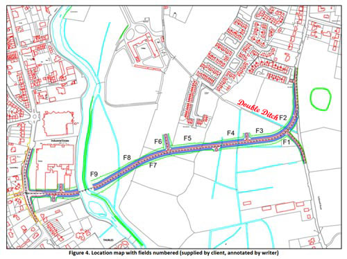
See also Road Design immediately hereunder. Note: the words ‘Double Ditch’ were placed on this map by Thurles.Info website and not by either author Mr F. Coyne or his client Tipperary Co. Council. The purpose of placing ‘Double Ditch’ on the map, here below is to demonstrate that the inner relief road will most likely impinge on the Great Famine Double Ditch in two places, see (1) between Field 4 (F4) and Field 3 (F3) and (2) between Field 3 (F3) and Field 2(F2). Note, the ‘Double Ditch’ itself is represented by the pale blue line running parallel with the printed words ‘Double Ditch’.
Figure 4, pictured above as stated, was ‘annotated by writer‘, meaning that notes were added to the diagram, giving explanation or comment. Same annotation was not supplied by Tipperary Co. Council.
Report Author: F. Coyne BA MIAI Client: c/o Michael Devery, North Tipperary County Council, Civic Offices, Nenagh, Co. Tipperary, Date: October 2013
1. Scope of Study. This report identifies and assesses the potential direct and indirect impact(s), if any, on the potential archaeological environment of a proposed relief road in the townlands of Clongower and Monakeeba, Glebe and Mullauns, Thurles, Co. Tipperary. This report fulfils the usual criteria of an archaeological impact assessment and follows the most recent EPA guidelines on the compilation of an EIS (2002; 2003). Pertinent guidelines published from time‐to‐time have also been consulted and are listed in the project references given at the back of this report. A brief historical introduction to the area is provided and archaeological features in the vicinity, including any standing remains, are discussed. The report details the potential archaeological and/or cultural heritage features on the site and in its vicinity and discusses the impacts, if any, of the development on that archaeology and/or cultural heritage. No intrusive archaeological investigations (test‐trenching or excavation) have been undertaken at this stage or as part of this desktop assessment. However a geophysical assessment has been carried out under licence number 13R11 at the location of RMP TN041‐043‐‐‐ enclosure. The site inspection on which this report is based was carried out on Wednesday 23rd October 2013.
2. Method of Study The following resources and methods of establishing the archaeological status of the site of the stone quarry were used:
The subject site was visited and inspected by a qualified archaeologist;
The Record of Monuments and Places constraint maps and lists (RMP) and the sites and monuments record archive (SMR) were examined;
A wide range of local historical and archaeological records relevant to the study area were consulted, including the Ordnance Survey First Edition six‐inch map (c.1840), the Ordnance Survey twenty‐five inch map and aerial views;
Thurles and Environs Development Plan 2009‐2015;
National Inventory of Architectural Heritage;
Topographical Files held in the National Museum of Ireland;
Archaeological Survey of Ireland files and publications;
A review of any archaeological investigations in the vicinity was also undertaken.
3. Existing Environment The subject site lies on the south‐eastern side of Thurles town, in an area of open fields through the townlands of Clongower and Monakeeba, then along the roadway which is also the townland boundary between Glebe and Monakeeba, and Mullauns and Monakeeba.
3.1 The Site Inspection The subject site was inspected on Wednesday 23rd October 2013. Weather conditions were showery. The subject site is a series of fields. For ease of reporting they were numbered in the direction in which they were walked, from east to west, (see figure below), and numbered F1 to F9.
The proposed road will run along Mill Road, past RMP TN41-044, before entering the green field area. [No mention of crossing a right of way or great famine Mass path, as clearly shown in Figure 4 above.]
Field 1 is a small field, covered in short grass and grazed by horses. Field 2 is a large open grassy field, covered in short grass and grazed by horses. Field 3 is a large open grassy field, covered in short grass and grazed by horses. It is very wet underfoot. Field 4 is a large open grassy field, covered in short grass and grazed by horses. It is extremely wet underfoot. Field 5 is a rectangular grassy field, located to the rear (south) of a housing estate. It is covered in short grass and grazed by horses. Mounds of rubble and topsoil are located at the eastern side of the field. Traces of cultivation ridges are to be seen throughout this field. Field 6 is a large open grassy field, covered in short grass and grazed by cattle. It is located along a natural ridge which runs in a general north‐south direction, and is drier than the land to the east and west. Field 7 is a large open grassy field, covered in short grass. It is located along a natural ridge which runs in a general north‐south direction, and is drier than the land to the east and west. The RMP TN041‐043 is located in this field along the crest of this ridge. Field 8 slopes from a high at east to lower ground at west, where rushes grow in abundance, possibly marking an old pond area. Traces of an old field boundary, running in an east‐west direction was also noted in this field. Field 9 contains several undulations, growths of rushes and is wet underfoot, and is adjacent to the river. It has the potential to contain previously unrecorded wetland archaeological sites, such as fulachta fiadh. [Fulachta fiadh is the name given to one of many burned mounds, dating from the Bronze Age, found in Ireland.] The eastern side of the proposed bridge will be located in this field. The proposed road will cross the River Suir at the location of a new bridge. At the western side of the river, it will run through the car park area of an industrial estate, before joining with the Slievenamon Road.
No previously unrecorded archaeological monuments were recorded during the inspection.
The Archaeological Impact Statement then goes on to discuss protected structures within the town, including structures on Slievenamon Road, before declaring, “There are no protected structures located on the subject site.”
This online statement will now be emailed, yet again, to the revelant government authorities, in the hope of getting a reply.
Some small hope now does exist, Knagg family members world-wide are keenly following our progress, or lack of same.
Only YOU and you alone can stop the current chain of virus transmission.
The Department of Health have confirmed that there have, sadly, been 28 further deaths caused by the Covid-19 pandemic; leaving the overall death toll, here in the Republic of Ireland, remaining at 4,109.
There have been 763 new additional virus cases reported within the republic today, or 11,759 in the past 14 days. This leaves the current total number of confirmed cases, since conception, here in the Irish Republic, at 213,400.
Relative to midnight last night, (February 18th), 7 further cases of Covid-19 were confirmed over the previous 24 hours, here in Co. Tipperary, with 241 cases identified within the same area; within the past 14 days.
Of the cases today; 251 are in Dublin, 84 in Galway, 57 in Kildare, 47 in Limerick, 42 in Waterford, with the remaining 282 cases located across all other counties.
There are 754 people with Covid-19 in hospital, and of that number, 151 are in ICU’s, according to Ireland’s COVID-19 Data Hub.
Some 7,950 fines have been issued by Gardaí to persons in breach of Covid-19 restrictions, with over 6,297 x €100 of these issued for non-essential travel and 263 x €500 for non-essential journeys abroad. Some 155 x €80 fines have been issued for refusal to wear face coverings.
The total world wide number of cases identified up to 5:30pm this evening, are now standing at almost 110.5 million confirmed cases, with global deaths well over 2.44 million.
This website uses cookies to improve your experience. We'll assume you're ok with this, but you can opt-out if you wish.AcceptRead More
Privacy & Cookies Policy
Privacy Overview
This website uses cookies to improve your experience while you navigate through the website. Out of these, the cookies that are categorized as necessary are stored on your browser as they are essential for the working of basic functionalities of the website. We also use third-party cookies that help us analyze and understand how you use this website. These cookies will be stored in your browser only with your consent. You also have the option to opt-out of these cookies. But opting out of some of these cookies may affect your browsing experience.
Necessary cookies are absolutely essential for the website to function properly. This category only includes cookies that ensures basic functionalities and security features of the website. These cookies do not store any personal information.
Any cookies that may not be particularly necessary for the website to function and is used specifically to collect user personal data via analytics, ads, other embedded contents are termed as non-necessary cookies. It is mandatory to procure user consent prior to running these cookies on your website.






Recent Comments