“What a tangled web we weave, when first we practice to deceive.“ Sir Walter Scott.
I received an email from the office of Mr Micheál Lowry on Monday, March 15th, 2021, at 17:08 (7 days ago).
It should be noted that the sender of the email, (content shown hereunder), appears to originate from the son of Mr Michael Lowry, Teachta Dála (TD); the former being a member of the “Lowry Team” group of Co. Councillors. Same in no way should be attributed to his father, latter TD, who also has refused to reply to any of my previous attempts to correspond.
The sender is the same man whom readers will remember, enquired from me, during a mobile phone call, (September 2020), asking quote “Who the f..k do you think you are?”
This confusing content contained in Mr Lowry’s only communication ever sent to me in relation to the destruction of the Great Famine Double Ditch is shown directly hereunder, in full; same raising more questions, than it offers answers.
Read Carefully between the lines
George In relation to your email dated the 4th of March, I wish to put on record that I nor to my knowledge any of my council colleagues have any desire to “destroy” the double ditch which you write about.
A small section of the walkway will potentially be removed to facilitate the proposed inner relief road for Thurles Town. While a map exists which outlines the proposed route (you have displayed same in previous articles) the fact remains that the County council have not at time of writing acquired the lands over which the proposed route will traverse. Should the lands be acquired and funding confirmed I along with my council colleagues will do all we can to ensure that minimum disruption is brought to bear on the double ditch walk way.
If you have any proposals as to how you would like to see the walkway promoted internationally as stated in your article dated March 5th please forward same to the area councillors for discussion as part of the Thurles Municipal projects development plan.
Regards Micheál Lowry.
Questions Raised: In Mr Lowry’s opening paragraph he states, “I nor to my knowledge any of my council colleagues have any desire to “destroy” the double ditch“. Then in his second paragraph he states, “A small section of the walkway will potentially be removed to facilitate the proposed inner relief road for Thurles Town.” Readers will no doubt find this statement contradictory.
Firstly, if this is the case why the refusal by all Municipal District / Co. Councillors and Council officials to initially communicate; forcing me to contact the Standards In Public Office Commission (SIPO)?
I have done the measurements. Is it not true that over half the double ditch, 250 yards approximately, will be eradicated, including its eastern 175 year old stone entrance?
Is it not true that contractors employed by Tipperary Co. Council have already partially undertaken the destruction of the 175 year old Great Famine Double Ditch, through digging out and flooding the northern side; breaking the eastern 175 year old stile entrance, while allowing the area to become a ‘fly-tippers paradise’?
Mr Lowry Jr. states, “the County council have not at time of writing acquired the lands over which the proposed route will traverse. Should the lands be acquired and funding confirmed I along with my council colleagues will do all we can to ensure that minimum disruption is brought to bear on the double ditch walk way.”
While I accept that Tipperary County Council may not have acquired the lands as yet as purchasers, we must believe that some sort of an agreement / consensus / accordance or indeed rapport has been entered into with all / any future vendors.
Who drew up the map, shown above, without the consent of the owner of the lands involved?
Who sought planning permission through An Board Pleanála, on land that are not yet acquired or entered into by agreement?
Who also sanctioned the undertaking of an EIA Screening report, (OCSC Project T189) on lands, where no previous agreement has been entered into?
Who requested the poorly carried out Archaeological Impact Statement from ÆGIS(REF.: 210-11), which failed to identify the double ditch shown clearly on the 1883 Ordinance Survey(5 inch) map, and more recently again also shown clearly on the 1951 ordinance survey map?
Who gave all these consultants and archaeologists permission to trespass on lands, where no agreement with the owners had been entered into between the vendors and by Tipperary Co. Council?
Will this land be acquired without the consent of the owners, by means of a Compulsory Purchase Order (CPO)? It is with regret that Cllr. Mr Jim Ryan, latter who lives close by the Great Famine Double Ditch, has failed to reply to two questions, sent to him on March 3rd last, (see request HERE).
In relation to your final paragraph and your request regarding “walkway promoted internationally”. When I am convinced that the 175 year old Great Famine Double Ditch will been retained in full, together with the provision of a small parking area for tourist traffic; God willing, I will begin the process of promotion and marketing, something that Tipperary Co. Council’s Tourism committee has failed miserably to achieve for Thurles. You will remember the disastrous costly promotion entitled, “Tipperary The Place, The Time” launched back in early 2017. Where did all of the TD’s, Ministers, Councillors and Celebs that were rounded up, go after the photographs and the expensive promotional banquet?
Our readers should note that I have not replied personally to the above email sent by Mr Lowry Jr., nor indeed currently do I intend to do so.
The original Ellis Island Immigration Station in New York Harbour was officially opened in 1892 and the first immigrant to pass through its doors was a 15 year old girl from County Cork, by the name of Annie Moore, (April 24th, 1877 – December 6th, 1924). Annie arrived from Cobh (Queenstown) in Ireland, aboard the steamship ‘Nevada’ in 1892. Her brothers, Anthony 14 and Philip 12, had journeyed with her.
Now a virtual exhibition entitled “Irish Famine Migrant Stories In Ontario” will tell the story of Ontario’s Irish migrants from 5 years earlier, “Black 47”(1847) and the caregivers who put their lives on the line, during one of the worst health-care crises recorded in Canadian history.
As officials in Tipperary Co. Council, together with local elected representatives and politicians (namely Mr Michael Lowry and Mr Jackie Cahill) support the destruction of our Great Famine history here in Thurles; this new exhibition will apprise the untold tales of Irish Great Famine migrants, who endured a typhus epidemic, while emigrating to Canada.
Created by the Ireland Park Foundation (IPF), this virtual exhibit, which took more than four years to assemble, will follow the lives of 100,000 famine migrants, latter who crossed the Atlantic Ocean landing in Grosse Isle, an island located in the St. Lawrence River in Quebec, Canada, and onto the shores of Ontario during this Great Hunger, on board ‘coffin ships’ that would claim the lives of some 20,000 people.
Some 16% of the population in Ontario, Canada, today can correctly claim Irish decent. Toronto back then, was largely a Presbyterian/Protestant city, while 80% of the Irish migrants arriving were Roman Catholic. This human melting pot of the late 1800’s laid the seeds to a diverse Canada population, the envy of the world, that we as Irish people today know and love.
In relation to our Double Ditch Survey sent to local elected representatives; same due to be returned last Sunday evening, March 14th; we can confirm that we have received some answers which will be published later.
Hereunder is a quote on the website run by the National Monuments Service.
“The National Monuments Service is reliant on landowners and the general public in fulfilling its role in the protection and preservation of our archaeological heritage and the assistance of the public is gratefully appreciated.”
“If you wish to report possible damage to a monument please contact the National Monuments Service by phoning 01 8882000 or e-mailing nationalmonuments@chg.gov.ie as soon as possible.”
This statement of encouragement by “The National Monuments Service” (a government body), can be viewed HERE.
Having been ignored by this very same government body, together with TD’s responsible for their sloppy operations, namely Mr Malcolm Noonan (Green Party) and Mr Darragh O’Brien (Fianna Fáil) for well over 12 months, I phoned their National Monuments Service offices today to be told that Tel: No. 01-8882000 was incorrect and that I should phone 01-8883200.
Having explained the issue for the umpteenth time to this department, on this occasion I was informed that “The National Monuments Service, were only interested in monuments which were 200 or more years old”.
I pointed out that the home of Michael Joseph O’Rahilly, known as ‘The O’Rahilly’, the only leader of the 1916 Rising to die in battle, had been reduced to rubble by developers Derryroe Ltd, in October of 2020. This same house, (like our Thurles, Great Famine Double Ditch) which also was not on the Record of Protected Structures (RPS) and had not any statutory conservation designations, was built in 1907. (61 years after the Thurles Great Famine Double Ditch project).
Unlike Thurles town, in the Michael Joseph O’Rahilly case, same were supported by Councillors, heritage groups, relatives of 1916 leaders, RTE TV and Radio, including O’Rahilly’s grandson Proinsias Ó Rathaille. The house was demolished on September 29th 2020 and one wonders was the case dealt with by the same individual I dealt with today, who informed me that ‘The O’Rahilly’ house “had history”. We ask the question are the National Monuments Service responsible for the loss of the ‘The O’Rahillyhouse’ and its huge historical significance.
Then came his joke of the century, “Write to Mr Michael Lowry TD or Mr Jackie Cahill TD, your public representatives”.
———————————————————————————
I now print hereunder, for the first time, relevant extracts from the Archaeological Impact Statement on the Great Famine Double Ditch, In Thurles.
I ask, please tell me, in case I have missed them, if in this Archaeological Impact Statement, you can find the words ‘Double Ditch’, ‘Mass Path’, ‘Public Right of Way’, or ‘Great Famine hunger relief project’? Despite its existence (see video above and historical evidence presented to date on Thurles.info) the Archaeological Impact Statement on this area makes no reference to the Double Ditch, despite Mr Coyne claiming he walked the fields which actually sandwich the ‘Double Ditch’.
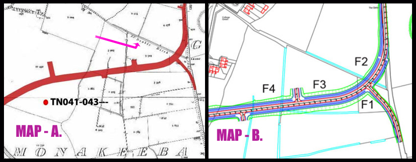
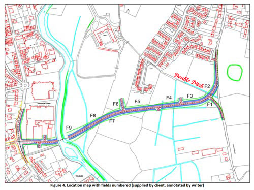
See also Road Design immediately hereunder. Note: the words ‘Double Ditch’ were placed on this map by Thurles.Info website and not by either author Mr F. Coyne or his client Tipperary Co. Council. The purpose of placing ‘Double Ditch’ on the map, here below is to demonstrate that the inner relief road will most likely impinge on the Great Famine Double Ditch in two places, see (1) between Field 4 (F4) and Field 3 (F3) and (2) between Field 3 (F3) and Field 2(F2). Note, the ‘Double Ditch’ itself is represented by the pale blue line running parallel with the printed words ‘Double Ditch’.
Figure 4, pictured above as stated, was ‘annotated by writer‘, meaning that notes were added to the diagram, giving explanation or comment. Same annotation was not supplied by Tipperary Co. Council.
Report Author: F. Coyne BA MIAI Client: c/o Michael Devery, North Tipperary County Council, Civic Offices, Nenagh, Co. Tipperary, Date: October 2013
1. Scope of Study. This report identifies and assesses the potential direct and indirect impact(s), if any, on the potential archaeological environment of a proposed relief road in the townlands of Clongower and Monakeeba, Glebe and Mullauns, Thurles, Co. Tipperary. This report fulfils the usual criteria of an archaeological impact assessment and follows the most recent EPA guidelines on the compilation of an EIS (2002; 2003). Pertinent guidelines published from time‐to‐time have also been consulted and are listed in the project references given at the back of this report. A brief historical introduction to the area is provided and archaeological features in the vicinity, including any standing remains, are discussed. The report details the potential archaeological and/or cultural heritage features on the site and in its vicinity and discusses the impacts, if any, of the development on that archaeology and/or cultural heritage. No intrusive archaeological investigations (test‐trenching or excavation) have been undertaken at this stage or as part of this desktop assessment. However a geophysical assessment has been carried out under licence number 13R11 at the location of RMP TN041‐043‐‐‐ enclosure. The site inspection on which this report is based was carried out on Wednesday 23rd October 2013.
2. Method of Study The following resources and methods of establishing the archaeological status of the site of the stone quarry were used:
The subject site was visited and inspected by a qualified archaeologist;
The Record of Monuments and Places constraint maps and lists (RMP) and the sites and monuments record archive (SMR) were examined;
A wide range of local historical and archaeological records relevant to the study area were consulted, including the Ordnance Survey First Edition six‐inch map (c.1840), the Ordnance Survey twenty‐five inch map and aerial views;
Thurles and Environs Development Plan 2009‐2015;
National Inventory of Architectural Heritage;
Topographical Files held in the National Museum of Ireland;
Archaeological Survey of Ireland files and publications;
A review of any archaeological investigations in the vicinity was also undertaken.
3. Existing Environment The subject site lies on the south‐eastern side of Thurles town, in an area of open fields through the townlands of Clongower and Monakeeba, then along the roadway which is also the townland boundary between Glebe and Monakeeba, and Mullauns and Monakeeba.
3.1 The Site Inspection The subject site was inspected on Wednesday 23rd October 2013. Weather conditions were showery. The subject site is a series of fields. For ease of reporting they were numbered in the direction in which they were walked, from east to west, (see figure below), and numbered F1 to F9.
The proposed road will run along Mill Road, past RMP TN41-044, before entering the green field area. [No mention of crossing a right of way or great famine Mass path, as clearly shown in Figure 4 above.]
Field 1 is a small field, covered in short grass and grazed by horses. Field 2 is a large open grassy field, covered in short grass and grazed by horses. Field 3 is a large open grassy field, covered in short grass and grazed by horses. It is very wet underfoot. Field 4 is a large open grassy field, covered in short grass and grazed by horses. It is extremely wet underfoot. Field 5 is a rectangular grassy field, located to the rear (south) of a housing estate. It is covered in short grass and grazed by horses. Mounds of rubble and topsoil are located at the eastern side of the field. Traces of cultivation ridges are to be seen throughout this field. Field 6 is a large open grassy field, covered in short grass and grazed by cattle. It is located along a natural ridge which runs in a general north‐south direction, and is drier than the land to the east and west. Field 7 is a large open grassy field, covered in short grass. It is located along a natural ridge which runs in a general north‐south direction, and is drier than the land to the east and west. The RMP TN041‐043 is located in this field along the crest of this ridge. Field 8 slopes from a high at east to lower ground at west, where rushes grow in abundance, possibly marking an old pond area. Traces of an old field boundary, running in an east‐west direction was also noted in this field. Field 9 contains several undulations, growths of rushes and is wet underfoot, and is adjacent to the river. It has the potential to contain previously unrecorded wetland archaeological sites, such as fulachta fiadh. [Fulachta fiadh is the name given to one of many burned mounds, dating from the Bronze Age, found in Ireland.] The eastern side of the proposed bridge will be located in this field. The proposed road will cross the River Suir at the location of a new bridge. At the western side of the river, it will run through the car park area of an industrial estate, before joining with the Slievenamon Road.
No previously unrecorded archaeological monuments were recorded during the inspection.
The Archaeological Impact Statement then goes on to discuss protected structures within the town, including structures on Slievenamon Road, before declaring, “There are no protected structures located on the subject site.”
This online statement will now be emailed, yet again, to the revelant government authorities, in the hope of getting a reply.
Some small hope now does exist, Knagg family members world-wide are keenly following our progress, or lack of same.
It was announced today that eleven Tipperary projects are to be included for funding, announced under the ‘Outdoor Recreation Infrastructure Scheme’.
The total funding announced for the county was €200,000, none of which was allocated to Thurles Town.
Just so as non local people fully understand; The Grange Loop, who bears the Thurles postal address, and who were rightly gifted €20,000; refers I believe to the lovely Grange Crag loop walk trailhead, in the Civil Parish of Kilcooly, Co. Tipperary, close to the Kilkenny border, latter a 21 minute drive from Thurles town, 21.5 km / 13.25 mls from Thurles, via the N75 minor road. [Surely, it hardly refers to the townslands of Grange, on the N62, (Brittas Road, Thurles. )]
No effort was made to get funding for the “Double Ditch” Mass Path, latter situated between the Mill Road, Thurles and College Lane in the town. But then our politicians and county councillors didn’t notify us, regarding any available government funding worthy of being sought.
We first raised issues regarding fly-tipping on the Great Famine “Double Ditch” on lands either side of same, owned by Tipperary Co. Council, on October 28th, 2019. ViewHERE.
Every official, local councillor and local politician were advised.
Today, some 15 months later, not one solitary item dumped back then, was ever removed.
See slide show hereunder, compiled from views captured in recent days.
On site today, (19th January 2021) the stolen shopping trolleys have doubled, so also the paper and other plastic litter, the discarded toys, the beer cans, and the bottles, the burnt household items, the cookers and fridges, the gym equipment, etc. etc. etc. All three original sweet crab trees, and some mature Hawthorn trees, have now been either burnt on site or cut down for firewood.
We are reminiscent of a town that refuses to pay Local Property Tax(LPT) and a town devoid of any real quality political or official leadership. The new council housing project being built on a flood plane and running parallel, is using the Double Ditch to drain flood water unto the ditch and through it, unto the land on the other side.
Yet the local people though solidly offended, stay silent, realising, not for the first time, that they are powerless in the face of constant political pretence and official deceipt and hogwash.
_______________________________________________
By the way, we received two communications relating to the Great Famine ‘Double Ditch’ in recent weeks. To refresh your memory, view links to read past such communications HERE.
The first recent communication came from Tipperary Fianna Fáil Councillor, Mr Sean Ryan.
Councillor Ryan confirmed in a Facebook private message in recent weeks, “I did enquire George, but still haven’t a definitive answer. When I do, I’ll let you know.” My question had been, “Is the Thurles inner relief road going to effect the Double Ditch”.
Note: This last question above was first asked originally in May 2020, over 8 months ago.
If Councillor Ryan’s answer is truly the case, it would appear that Tipperary Council officials are also refusing to communicate with all elected representatives; since all elected representatives, contacted by me, remain silent on this issue.
This is despite being instructed to communicate with me by Tipperary Co. Council’s ‘Ethics Registrar‘, namely Mr. David Coleman, (Administrative Officer, Corporate Services), who contacted all Councillors, yet same continue to openly resist and refuse to obey his instructions, thus fully ignoring their required Code of Conduct, demanded under the Local Government Act of 2001.
Note: An email message does not carry Covid-19 virus infection.
—————————————————————-
The second communication arrived from Ms Máire Ní Chonghaile (National Monuments Service) on Christmas Eve last, 24th Dec. 2020, at 10:11am.
Ms Máire Ní Chonghaile wrote: –
Dear Mr Willoughby I refer further to your email below. The Double Ditch is not a Recorded Monument and it is not afforded legal protection under the National Monuments Acts 1930-2014. The concerns raised appear to relate to planning and development, which is a matter for the Local Authority. Wishing you a happy Christmas. Kind regards Máire
Allowing for Christmas leave etc, I replied to Ms Máire Ní Chonghaile on Wednesday night, 13th January 2020 at 20:46, as follows: –
To Ms Máire Ní Chonghaile Madam, I am saddened to note that your office has obviously not read anything that I sent to your department, in the last year. I am fully aware this is not a recorded monument. The reason I wrote to you in the first place was for you to investigate my claim and have it declared such, thus, affording legal protection under the National Monuments Acts 1930-2014.
Perhaps I need to clarify this issue in simpler terms.
On Tue, 12 Nov 2019, 13:40, I contacted Ms Roisin O’Grady (roisin.ogrady@tipperarycoco.ie). Latter is Heritage Officer with Tipperary County Council at Ballingarrane House, Cahir road, Clonmel, Co. Tipperary, To Ms Roisin O’Grady, In keeping with Tipperary County Councils promise to “promote awareness and appreciation of our rich heritage and to protect and enhance it for future generations” may I request that you take time to view the following link: – http://www.thurles.info/2019/10/28/thurles-double-ditch/.
Remembering that next year (2021) is the 175 year in which we commemorate the ‘Great Famine’; the images in the slide show provided by the link shows clearly that among other improprieties and illegalities, barbed wire has been recently introduced on a public monument, on a public right-of-way which is also formerly a ‘Mass Path’ and was one of the first projects undertaken to assist in feeding the poor of Thurles. The slide show demonstrates clear evidence of neglect, vandalism and a convenient land grab by land owners on either side, latter reducing the width of the pathway to one of single file.
Yours sincerely George Willoughby
I briefly met with the said Ms O’Grady at 2.30pm on the Great Famine Double Ditch in Thurles on 22nd Nov. 2019 and requested that she contact the National Monument section, regarding the need to declare this area, itself, a national monument.
Correspondence from Ms O’Grady came dated Thur, 27th Feb. 2020, at 16:08.
It read: – George A quick line just to say I haven’t forgotten about your query, but there has been a lot of applications due in the last few weeks so I am slower than expected tracking down the necessary information. I will revert in due course once I have some information for you.
Regards Róisín O’Grady
This was the last communication I ever had from Ms O’Grady, despite contacting her office on several occasions.
Note: The great famine double ditch is being totally ignored, despite Tipperary Co. Council owning the land on either side.
I have since discovered, based on documentation obtained from Tipperary Co. Council offices, that Tipperary Co. Council intend to demolish this ‘Double Ditch’ to provide an inner relief road for the town. Ms O’Grady’s silence perhaps is being controlled by someone or something that is much more powerful.
A copy of an Archaeological Survey (See attached) is grossly misleading. Note: The Great Famine Double Ditch is totally and I believe deliberately ignored within this document, despite Tipperary Co. Council owning the land on either side.
Perhaps you could confirm also, if Ms O’Grady ever contacted your office, seeking legal protection for the Great Famine, Double Ditch, under the National Monuments Acts, which was requested by me in November 2019 or do we have a case of the tail(namely Tipperary Co. Council) wagging the dog(Tipperary’s own Co. Council Heritage Office ).
In all, now to-date, 16 persons, including senior Co. Council officials, e.g Mr Joe MacGrath (CE, Tipperary Co. Council);4 Teachtaí Dála; two of which support this present government here in Co. Tipperary, [namely MrMichael Lowry and Mr Jackie Cahill, Minister Malcolm Noonan, (latter Minister of State for Heritage and Electoral Reform), and Minister Darragh O’Brien, (latter Minister for Housing, Local Government and Heritage), all of whom have failed to answer the simple question; “Will the planned Thurles inner relief road impinge, in a negative way, on the 1846 Thurles ‘Double Ditch’, which has been a “Right of Way” and a “Mass Path” for almost 175 years and which is the property of the people of Thurles Town?”
In the interests of openness and transparency we would like to publish three communication received, two by email, together with my two replies; and one in a comment sent in relation to the ‘Great Famine Double Ditch’ enquiry.
Let me first deal with the comment received from Fianna Fáil TD Mr Jackie Cahill.
Mr Cahill’s comment to this website today posted exactly as shown here, (Including the spelling mistakes): –
Author: Jc Email: Jackie.cahill@oir.ie Comment: “Iv done more in 5 years than you have in youre life GEORGIE WILLOBY. Stop emailing.“
Mr Cahill you are correct, unlike you, I have never taken €1,800 per week in salary, plus expenses, from the public purse while masquerading as an elected politician.
I have honoured Mr Cahill TD’s wishes, in the full knowledge that same Mr Cahill never answers any correspondence sent to his email account. However, perhaps Mr Cahill could name just one project that he has been successful in bringing to fruition in the last 5 years, while earning his €1,800 per week.
The first of two email communications came from Mr David Coleman(Ethics Registrar, Tipperary County Council.)
Same reads: –
Dear Mr. Willoughby,
Your email of 27th September below refers. Your query concerning the response you received in relation to the “Thurles Double Ditch” has been referred to the Thurles District Administrator for follow up with the relevant Directorate as is your request for a copy of the 3 documents referenced.
I wish to confirm that I am the Ethics Registrar for Tipperary County Council with effect from 1st June 2020 and as previously advised, legislation requires that this position is not held by the same person for a period longer than 2 years, hence the reason that you would have been initially informed that Mr Ger Walsh was previously the Ethics Registrar. Unfortunately, our website had not been updated at the time but I can advise that this has now been rectified.
As I have previously stated, each of the seven elected members of the Thurles Municipal District were reminded of their requirement to have regard to and be guided by the Code of Conduct. Regarding the Council officials you asked questions of, the reply which you received from the Acting District Manager included relevant input from these officials and going forward, similar queries concerning the Thurles Municipal District area should be sent in the first instance to the Thurles District Administrator for coordination and direct reply to yourself.
Yours Sincerely David Coleman (Ethics Registrar)
My email reply to Mr Coleman read: –
For the attention of Mr David Coleman.
Sir, Thank you for your communication of the 8th instant. Following your instruction to Ms Janice Gardiner, the material requested 3 weeks ago, (September 17th), was forwarded to me yesterday, October 9th.
From reading the content received it is obvious why the material was slow to materialise.
As you are aware, as yet no satisfactory reply to my question has come from Ms Gardiner.
Note the question was: – “Will the planned Thurles inner relief road impinge, in a negative way, on the 1846 Thurles “Double Ditch”, which has been a right of way and a Mass Path for almost 175 years and which is the property of the people of Thurles and a National Monument?”
However, following my own intensive investigations I am now fully aware of the answer to that latter question. A reply from Ms Gardiner and all other elected local councillors and Co. Council officials are no longer required.
However, I thank you for your swift intervention in this matter as Ethics Registrar for Tipperary County Council.
Yours sincerely, George Willoughby
The second email communication arrived on Friday last, October 9th, 2020, from Ms Janice Gardiner(Acting District Administrator, Thurles Municipal District, Tipperary County Council, Castle Avenue, Thurles, Co. Tipperary).
This communication read: –
Dear Sir, Please see attached documents as requested.
Regards, Janice Gardiner
For Your Information: – Documents requested were: –
An Bord Pleanala Report PL79.JP0024
2013 EIA Screening Report
2013 Archaeological Impact Statement.
My email reply to Ms Gardiner read: –
Attention of Ms Janice Gardiner.
Madam,
I acknowledge and thank you for your communication of the 9th instant and the attachments, first requested on September 17th 2020 last. Yours sincerely. George Willoughby
In the next day or two, the results of my investigations will be published here in full detail.
This website uses cookies to improve your experience. We'll assume you're ok with this, but you can opt-out if you wish.AcceptRead More
Privacy & Cookies Policy
Privacy Overview
This website uses cookies to improve your experience while you navigate through the website. Out of these, the cookies that are categorized as necessary are stored on your browser as they are essential for the working of basic functionalities of the website. We also use third-party cookies that help us analyze and understand how you use this website. These cookies will be stored in your browser only with your consent. You also have the option to opt-out of these cookies. But opting out of some of these cookies may affect your browsing experience.
Necessary cookies are absolutely essential for the website to function properly. This category only includes cookies that ensures basic functionalities and security features of the website. These cookies do not store any personal information.
Any cookies that may not be particularly necessary for the website to function and is used specifically to collect user personal data via analytics, ads, other embedded contents are termed as non-necessary cookies. It is mandatory to procure user consent prior to running these cookies on your website.

Recent Comments