Project first proposed in 2009 seen as key to easing Thurles congestion and boosting local economy.
The long-awaited Thurles bypass is expected to feature in the forthcoming revision of the National Development Plan (NDP), which is due to be formally announced on Tuesday, November 25th.
First proposed in 2009, the project was shelved following the economic crash, but has remained a long-term priority for the business community. The long awaited bypass is viewed as being critical to easing chronic traffic congestion in the town and hopefully unlocking the towns wider economic potential.
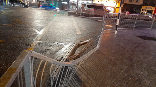
Damage caused on a regular basis by heavy goods vehicles. Pic: G. Willoughby.
Traffic volumes in Thurles, particularly heavy goods vehicles passing through Liberty Square, have long been a source of frustration for residents and businesses, as two national secondary routes currently converge in the town centre.
Damage caused on a regular basis by heavy goods vehicles. Pic: G. Willoughby
Detailed design work on associated relief roads has also been completed, with supporting documentation now under review as part of the statutory approval process.
This news indicating that the bypass will proceed, will be greatly welcomed by both business and community leaders in Thurles same seen as essential to ensuring Thurles can thrive as a safe and accessible regional hub.
If fully confirmed in the updated NDP, the Thurles bypass would represent one of the most significant infrastructure commitments for mid-Tipperary in recent decades. Construction is expected to follow later in the plan’s timeline, subject to final funding and planning approvals.
The revised National Development Plan will be formally announced on Tuesday, November 25th, and it will then fall to our local representatives to help drive forward a project they have in the past been slow to champion.
For Ireland’s upcoming EU Presidency to carry real democratic weight, the Government must move beyond token consultation and create genuine channels for citizens to shape the nation’s European agenda.
How the Irish Public Can Engage Meaningfully in Ireland’s EU Presidency Consultation (2026).
From 1st July to 31st December 2026, Ireland will assume the Presidency of the Council of the European Union; a position that will place the Irish Government at the centre of EU policymaking for six crucial months. Ahead of this, the Department of Foreign Affairs has now invited views from domestic stakeholders and the public on the priorities that should shape Ireland’s Presidency programme.
Domestic stakeholders and the public who wish to express views – Please See HERE.
On paper, this is an admirable democratic exercise. In practice, however, the distance between the government and the citizen in Ireland has grown markedly, especially in recent years. Many people find it increasingly difficult to have queries answered by TDs or to receive substantive engagement from government Ministers and government Departments. Political dialogue has become one-directional with official statements flowing outward, but public input rarely finds its way back in.
To further prove this point I personally contacted 14 elected Irish TD’s, at the highest level, via email, during the time of this present government and, indeed, the previous government. I received acknowledgements from all 14, but sadly never any replys to the various queriesI thenhighlighted.
If this consultation is to be more than a box-ticking exercise, the Government must create mechanisms that allow citizens to contribute ideas, challenge assumptions, and hold policy-makers accountable for how their feedback is used.
A number of practical steps could make that possible: Regional Forums: Host open hearings in towns and cities across Ireland — akin to the Citizens’ Assembly format — where ordinary citizens, community organisations, and businesses can voice views on EU priorities such as energy security, migration, the digital economy, and climate policy. Online Platform: Establish a transparent online portal where individuals can submit policy suggestions, endorse others’ proposals, and see how those inputs are reflected in the final Presidency agenda. Sectoral Round-tables: Engage directly with universities, trade unions, youth groups, farmers, and SMEs to capture the breadth of Irish experience and expertise. Public Accountability: Publish a detailed summary showing which ideas were adopted or rejected, and why.
This kind of participatory approach would do more than enhance policy legitimacy. It would also help to restore public faith in democratic dialogue, at a time when trust in institutions and in politics itself is under strain.
An inclusive, transparent consultation process would ensure that Ireland’s EU Presidency is informed not only by officials in Dublin, but by the lived experience of Irish society. That would make the EU Presidency not merely an administrative duty, but a national expression of Ireland’s values and voice in Europe.
Note:The deadline for receipt of submissions is Friday 12th December 2025. If you have any questions, please send your query to the email address hereunder.
Barriers to investment in climate adaptation explored in new joint report by Climate Change Advisory Council and Central Bank of Ireland.
A new joint report by the Climate Change Advisory Council and the Central Bank of Ireland has warned that the deployment of climate adaptation finance is below what is required to address the escalating risks posed by climate change. Without action, the impact of extreme weather events will test Ireland’s economic and financial resilience.
While there is significant ambition to reduce emissions, focus must also be applied to addressing the impacts of climate change that are already emerging by enabling investment in climate adaptation projects at both national and local levels. Many adaptation projects, particularly at local levels, are seen as too small or too uncertain to secure funding, even though their benefits are clear and long-lasting.
Deep rooted barriers to investing in climate adaptation include a lack of locally relevant climate risk data, high upfront costs of adaptation projects, fragmented access to funding, and the absence of clear investment pathways that can attract private capital.
The report emphasises the importance of credible transition plans to build resilience in the financial sector and contribute towards a resilient economy. Actionable solutions include transition planning that incorporates adaptation, and the development of scalable, investable project models, and a register of successful adaptation projects to build momentum and share solutions.
Insurance is a key part of adaptation finance but protection gaps (where businesses, individuals and communities lack adequate or affordable insurance) pose a significant barrier to resilience. The report notes the need to address the insurance protection gap as set out in the Action Plan for insurance reform. This requires a long-term strategic approach to flood insurance with enhanced data sharing and a clear recognition of adaptation measures, as well as ensuring solutions are complemented by continued investment in measures such as flood defences to reduce risks and safeguard long-term sustainability.
Another challenge in assessing the scale of investment required is the absence comprehensive estimates of the short- and long-term costs of climate adaptation. The report proposes a National Adaptation Finance Strategy to attract private and EU funding which should build on improved estimates of long-term investment needs.
Commenting, Professor Mr Peter Thorne, Chair of the Climate Change Advisory Council’s Adaptation Committee said, “The recommendations within this report come at a critical time with the ever increasing frequency and impact of extreme weather events which are wreaking havoc across communities and the economy. The development of resilient infrastructure, storm resistance in coastal defences, drought-resistant crops, nature-based solutions, early warning systems and community resilience building would be transformative for our society saving lives and protecting livelihoods. By addressing barriers, mobilising public and private finance, and implementing innovative solutions, Ireland can build a more resilient economy and society while reducing risks to the financial system.”
Mr Vasileios Madouros, Deputy Governor of Monetary and Financial Stability for the Central Bank of Ireland, said, “Climate change poses risks to the financial system and the long-term stability of our economy. We’re already seeing the impact extreme weather has on communities, businesses and infrastructure, and we recognise the importance of addressing climate-related risks, including the growing need for investment in adaptation measures. This joint report proposes actionable steps to build resilience in the economy by increasing the deployment of adaptation finance in Ireland. Safeguarding Ireland’s financial stability in the face of a changing climate requires collaboration across public and private sectors, enabling investment at both national and local levels, and further assessing the short and long-term costs of climate adaptation.”
€447,300 awarded to extend walking route via Mill Road, in Thurles.
It is with great pleasure that the community of Thurles welcomes a landmark advancement in local amenities: a generous fund of €447,300 has now been secured by Thurles Lions Club to realise the long-awaited 5 km looped walk extension, starting from the heart of Thurles town-centre before meandering along the N62 national route to the “Lady’s Well” path stile entrance, positioned some 100 metres north of Thurles Golf Club. By following Lady’s Well main path, the rambler will then join the route at Mill Road (formerly Manor Mill Road, latter the ‘rat run’ or current inner relief road, for vehicles avoiding Thurles town) and the road locally known, affectionately, as “Fat Arse Boulevard”.
This funding is part of a number of Tipperary projects that have been allocated more than €900,000 between them to improve outdoor recreation facilities, is a minor part of a national fund of €16.5 million for 63 projects.
Footpath plans advance for Mill Road in Thurles.
Following the first publication of the planning application by Tipperary County Council, on 24th July 2024, same seeking the installation of a footpath on the Mill Road corridor, the project has now progressed significantly. Land access has been graciously granted by local residents along Mill Road, with, we understand Tipperary Council bearing the cost of acquisition. This co-operation paves the way for the looped walk to become a safe, well-designed pedestrian route for the community.
When complete, the new path will link the town centre securely with the outskirts of the town, via an attractive, town-to-country route, promoting greater recreational walking, better access for all ages, and contributing to the well-being and amenity of the Thurles area. Observers have welcomed the scheme as a vital safety upgrade, especially along Mill Road, where pedestrian access had long been compromised by traffic speeds and inadequate parking provision.
When the local TDs catch wind of this scheme, their press releases will no doubt exclaim with great gusto how utterly thrilled they are to have “secured” this funding, for a project they only discovered existed yesterday via their inbox.
This awarding of funding marks a significant milestone, after one year and three months since the application’s initial publication, and confirms a concrete step towards long-envisioned connectivity for the region. Next steps will include detailed design, boundary works, signage, landscaping (including new native hedging) and final construction of the concrete 1.8-metre wide footpath along the route from the existing built-up path towards the bridge at Lady’s Well.
Residents, walkers, cyclists and families in Thurles now have cause to look forward with genuine excitement, the promise of “Fat Arse Boulevard” becoming a cherished walking loop is now indeed on its way to realisation.
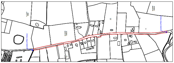
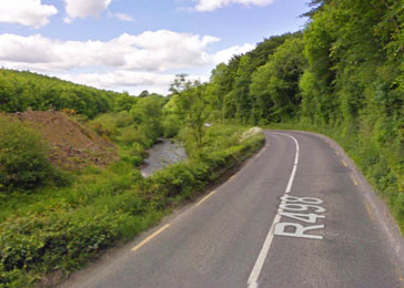
Work on a major multi-million euro roads project, in north Tipperary, is set to get underway in the coming weeks, following the appointment of a contractor to carry out the works.
Tipperary County Council has confirmed that Wills Bros Ltd has been appointed as the main contractor for the Latteragh Bends Road Realignment Project, which will see a dangerous stretch of road between Thurles and Nenagh finally upgraded.
The €30 million scheme will involve the realignment and improvement of a 4.3km section of the R498 regional road, between Nenagh and Thurles, at Latteragh, situated around 7km south-east of the M7 Nenagh Bypass.
According to the council, the contractor is now mobilising and setting up the site compound. Hedge cutting is due to begin next week, with traffic management measures to follow as full construction ramps up.
More than 30 local landowners were involved in compulsory purchase agreements to allow the scheme to proceed.
Funding for the project has been provided by the Department of Transport, which has allocated €20 million towards the works. A further €4 million has been set aside to cover design fees, consultancy, and landowner compensation.
The project aims to improve safety and traffic flow on one of the county’s key regional routes, long identified as a collision-prone stretch.
This website uses cookies to improve your experience. We'll assume you're ok with this, but you can opt-out if you wish.AcceptRead More
Privacy & Cookies Policy
Privacy Overview
This website uses cookies to improve your experience while you navigate through the website. Out of these, the cookies that are categorized as necessary are stored on your browser as they are essential for the working of basic functionalities of the website. We also use third-party cookies that help us analyze and understand how you use this website. These cookies will be stored in your browser only with your consent. You also have the option to opt-out of these cookies. But opting out of some of these cookies may affect your browsing experience.
Necessary cookies are absolutely essential for the website to function properly. This category only includes cookies that ensures basic functionalities and security features of the website. These cookies do not store any personal information.
Any cookies that may not be particularly necessary for the website to function and is used specifically to collect user personal data via analytics, ads, other embedded contents are termed as non-necessary cookies. It is mandatory to procure user consent prior to running these cookies on your website.


Recent Comments