Tipperary parking shake-up to go to consultation in early 2026, with Thurles calls growing to scrap charges.
A countywide overhaul of parking charges and permits across Tipperary’s nine pay-parking towns is due to go to public consultation in early 2026, after councillors examined proposals at a series of workshops aimed at “harmonising” how parking is managed from town to town.
The characterisation of Thurles town centre as “just a drive through area” reflects ongoing public concerns about traffic congestion and the impact of traffic management schemes on the town’s future vitality.
The nine towns currently within the Council’s eParking/pay-parking system are Thurles, Cahir, Carrick-on-Suir, Cashel, Clonmel, Nenagh, Roscrea, Templemore and Tipperary Town.
What’s in the proposals (as currently outlined)? Three-tier classification: the nine towns would be grouped into Tier 1, Tier 2 or Tier 3, with a different pricing structure depending on classification. First 20 minutes free: the plan would introduce a formal 20-minute free-parking period in each town when implemented (reported for September 2026). Charging hours: parking charges are proposed to apply 8.30am–6.30pm, every day except Sunday. Permit overhaul: reforms are proposed for the full range of permits, including categories such as residential and visitor permits, alongside other permit types. Off-street incentives and local “return” of revenue: the outline includes lower charges for off-street parking and a new approach to how parking income is used locally (with towns retaining a share of additional revenue above an agreed baseline). Submissions urged: the public are being encouraged to make submissions, seeking calls for one hour duration in free parking, rather than 20 minutes.
Why Thurles is central to the debate.
Despite Tipperary County Council initiatives framed as boosting Thurles town-centre trade and footfall (including measures such as time-limited free parking promotions), local retailers have long argued the centre cannot compete with shopping centres offering easier/free parking. They say that, following recent town-centre parking changes and the loss/uncertainty around key capacity, shopper activity has increasingly gravitated towards Thurles Shopping Centre and LIDL on Slievenamon Road, to the detriment of town-centre shops, because sufficient convenient parking has not been maintained with recent upgrading.
In Thurles, the conversation is being shaped by a series of recent town-centre parking and traffic changes, including:
A push to increase short-stay turnover in central areas, following concerns that all-day parking by workers was squeezing out shoppers.
Ongoing controversy around plans linked to Liberty Square, where parking spaces have been a recurring flashpoint.
The introduction of updated local rules under Thurles Municipal District Parking Bye-Laws 2025, adopted by elected members and brought into effect in April 2025.
Pressure on supply from the loss/closure of key town-centre parking, including the Munster Hotel car park closure, Market Area and The Source closures, alongside other long-term reductions referenced locally (reported as over 100 spaces).
“Abolish charges altogether” – the emerging Thurles position. Against that backdrop, the argument being made by some in Thurles is straightforward: because the town centre has already absorbed significant disruption and a tightening of parking availability, parking charges should be abolished altogether rather than “rebalanced.” There is precedent for this stance in the Liberty Square context, with calls previously made for parking charges to be suspended in Thurles during major works to help protect footfall.
What happens next ? The Council is expected to publish consultation details in early 2026, allowing residents, traders and commuters to lodge submissions on:
the tiering model,
the free-parking period,
charging hours and enforcement,
permit eligibility and pricing,
how parking income should be reinvested locally.
Tipperary County Council already uses its online portal to run formal public consultations on matters of upgrading and parking bye-law proposals, however, the petty exercise of same authority, by minor officials is perceived only as a “tick box” exercise, rather than a meaningful tool for future public consultative policy development.
Application Ref: 2561248. Applicant: Joseph Hawe Development Address: The Heath , Thurles , Co. Tipperary Development Description: an as constructed domestic garage and all associated site works Status: N/a Application Received: 03/12/2025 Decision Date: N/A Further Details:http://www.eplanning.ie/TipperaryCC/AppFileRefDetails/2561248/0
Application Ref: 2560884. Applicant: Nicole O’Brien & Liam Moore Development Address: Beakstown , Thurles , Co. Tipperary. Development Description: a storey & a half dwelling with entrance, garage, septic tank and percolation area with all associated siteworks and ancillary works Status: Conditional Application Received: 08/09/2025 Decision Date: 04/12/2025 Further Details:http://www.eplanning.ie/TipperaryCC/AppFileRefDetails/2560884/0
Application Ref: 2561220. Applicant: Michael Campbell. Development Address: Stradavoher, Thurles, Co. Tipperary. Development Description: construction of a 1.5-storey private dwelling, utilising the existing permitted vehicular entrance onto Stradavoher Road (Reg. Ref. 19601054), connection to the public water supply and public foul sewer, provision of SuDS-compliant surface water drainage. Status: N/A. Application Received: 27/11/2025. Decision Date: N/A. Further Details: http://www.eplanning.ie/TipperaryCC/AppFileRefDetails/2561220/0
Application Ref: 2561217. Applicant: Rory O’Regan. Development Address: Knockroe, Thurles , Co. Tipperary. Development Description: a new dwelling house, alteration of entrance from previously granted planning reference no. 2560354 to include re-routing of truck entrance and to form a new domestic entrance, new wastewater treatment system and all associated site works. Status: N/A. Application Received: 26/11/2025. Decision Date: N/A. Further Details: http://www.eplanning.ie/TipperaryCC/AppFileRefDetails/2561217/0.
Application Ref: 2561219. Applicant: Damien Ryan. Development Address: At The Corner Of Westgate And Croke Street , Thurles , Co. Tipperary. Development Description: for change of use of existing ground floor from retail/commercial use to residential use, with changes to the front and side elevations of the existing building with all associated siteworks. Status: N/A. Application Received: 26/11/2025. Decision Date: N/A. Further Details: http://www.eplanning.ie/TipperaryCC/AppFileRefDetails/2561219/0.
Application Ref: 25209. Applicant: Coolross Homes Ltd. Development Address: Thurles Townparks Bohernamona And Bowling Green , Thurles , Co. Tipperary Development Description: demolition of existing wall at Bohernamona Road, Thurles and creation of new vehicular and pedestrian entrance from Bohernamona Road, creation of new crossing point via raised table from the application site to the existing playpark at Loughtagalla Park, Status: Refused Application Received: 06/10/2025 Decision Date: 26/11/2025 Further Details: http://www.eplanning.ie/TipperaryCC/AppFileRefDetails/25209/0
Application Ref: 25208. Applicant: Coolross Homes Ltd. Development Address: Lands To The North Of Mitchel Street, Thurles Townparks And Bohernamona , Thurles, Co. Tipperary. Development Description: demolition of a section of wall (in part) at Mitchel Street and partial demolition of 3 no. outbuildings within the site to create a point of vehicular, pedestrian and cycle access from Mitchel Street north into the site; development of 75 no. residential. Status: Refused. Application Received: 06/10/2025. Decision Date: 26/11/2025. Further Details: http://www.eplanning.ie/TipperaryCC/AppFileRefDetails/25208/0.
Application Ref: 2560835. Applicant: Michael Quinlan. Development Address: 10 Butler Avenue, Thurles, Co. Tipperary. Development Description: a new extension to the rear of the existing dwelling and RETENTION PERMISSION for a new vehicular entrance to the front of the property and all associated site works Status: Conditional. Application Received: 26/08/2025. Decision Date: 24/11/2025. Further Details: http://www.eplanning.ie/TipperaryCC/AppFileRefDetails/2560835/0.
Application Ref: 2560563. Applicant: Patrick Ryan Development Address: 21 Butler Avenue , Thurles , Co. Tipperary Development Description: the construction of a new first floor extension to the rear of an existing dwelling, with changes to existing floor plan and elevations and all associated siteworks Status: Conditional. Application Received: 16/06/2025 Decision Date: 28/11/2025. Further Details: http://www.eplanning.ie/TipperaryCC/AppFileRefDetails/2560563/0.
Application Ref: 2561181. Applicant:MrJohn Ryan (Ned). Development Address: Wolfe Tone Place , Thurles , Co. Tipperary. Development Description: the construction of an extension (south of existing structure) and undertaking of alterations to a property adjoining and within the curtilage of a protected structure (TRPS2503)(Eircode E41 PX09). Permission for completion of works relating to this extension. Status: N/A Application Received: 19/11/2025 Decision Date: N/A Further Details:http://www.eplanning.ie/TipperaryCC/AppFileRefDetails/2561181/0
Application Ref: 2561182. Applicant:MrJames Burke. Development Address: Rossestown , Thurles , Co. Tipperary. Development Description: a four bedroom bungalow, new entrance, garage, wastewater treatment system and all associated site works. Status: N/A. Application Received: 19/11/2025. Decision Date: N/A. Further Details:http://www.eplanning.ie/TipperaryCC/AppFileRefDetails/2561182/0
Thurles Bypass confirmed in the updated NDP today, a major step forward.
Major Step Forward as Project Enters Pre-Approval Stage Under Government’s Updated Framework.
Now classed as a priority project, it will advance through design & planning, with a push to be construction-ready by 2030.
The long-awaited Thurles Outer Bypass has been formally included in the revised National Development Plan (NDP), announced today, November 26th, 2025. The confirmation marks a significant milestone for the town of Thurles and the wider mid-Tipperary region, placing the long-discussed project back onto the national agenda and ensuring it will now advance through the required planning and design phases.
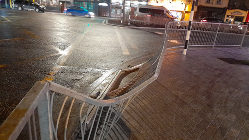
Damage caused on a regular basis by heavy goods vehicles. Pic: G. Willoughby.
Project Confirmed Under Appendix A of the National Development Plan. According to today’s announcement, the Thurles Bypass is listed within Appendix A of the NDP and designated to progress through the Pre-Approval / Gateway 1 stage. However, this represents only the first formal step in the Government’s project-delivery process, enabling detailed assessment, updated design work, and the preparation of a preliminary business case. The scheme is viewed as essential to addressing long-standing congestion and safety concerns, as well as supporting the town’s commercial and residential development.
Damage caused on a regular basis by heavy goods vehicles. Pic: G. Willoughby.
Associated Road Projects Also Advancing. Today’s publication confirms that the Thurles Bypass will sit alongside other significant transport projects for the area, including:
Thurles Inner Relief Road.
Local realignment schemes intended to improve connectivity and traffic flow.
Additional regional investments aimed at strengthening transport infrastructure across County Tipperary.
These projects combined form an integrated approach to improving mobility, safety, and economic prospects for Thurles town and surrounding areas.
Next Steps: Planning, Design and Approvals: While the Thurles bypass’s inclusion in the NDP does not indicate an immediate start to construction, it does secure its place within the Government’s investment programme through to 2030. The project will now move into:
Updated design and engineering work.
Preparation of statutory documents.
Preliminary business case development.
Environmental and route-corridor assessments.
Progression through further Government approval gates.
List of Strategic Regional Road Projects Scheduled to Commence Construction by 2030.
Project.
Sponsoring Agency.
Current Stage of Project Lifecycle.
Next Approval Gate.
Procurement Timeline.
Construction Timeline.
Successful Tenderer.
Cost Range.
Thurles Inner Relief Road.
Tipperary County Council
Final Business Case
AG1
Procurement by 2026
Commence by 2027
Not yet awarded
€10m- €20m
Appendix A. Thurles Bypass.
Various
Pre-AG1
AG1
?
?
?
?
See table above: “There’s many a slip ‘twixt the cup and the lip.”King Ancaeus of Samos.
It is now important, unlike in the past, that local representatives, at all levels, emphasise their intention to push for tangible, measurable progress on this project, so that the scheme can be construction-ready by 2030.
A Long-Awaited Boost for Thurles. The bypass is widely regarded as a crucial infrastructure project for Thurles. Heavy traffic, including a high volume of HGVs, currently passes through the town centre, particularly in Liberty Square where national routes intersect. Business groups, residents, and community organisations have repeatedly highlighted the impact on safety, air quality, congestion, and commercial activity.
Today’s confirmation is seen as the first real movement on the project in many years, following earlier plans which stalled during the economic downturn.
This website uses cookies to improve your experience. We'll assume you're ok with this, but you can opt-out if you wish.AcceptRead More
Privacy & Cookies Policy
Privacy Overview
This website uses cookies to improve your experience while you navigate through the website. Out of these, the cookies that are categorized as necessary are stored on your browser as they are essential for the working of basic functionalities of the website. We also use third-party cookies that help us analyze and understand how you use this website. These cookies will be stored in your browser only with your consent. You also have the option to opt-out of these cookies. But opting out of some of these cookies may affect your browsing experience.
Necessary cookies are absolutely essential for the website to function properly. This category only includes cookies that ensures basic functionalities and security features of the website. These cookies do not store any personal information.
Any cookies that may not be particularly necessary for the website to function and is used specifically to collect user personal data via analytics, ads, other embedded contents are termed as non-necessary cookies. It is mandatory to procure user consent prior to running these cookies on your website.


Recent Comments