This Wednesday, April 1st, history comes alive across Ireland, but nowhere more vividly than in the heart of Tipperary. As part of the popular “Free Wednesday” initiative, visitors are invited to step beyond the everyday and into centuries of rich heritage, with free access to nearly 40 iconic sites nationwide. From majestic castles to hidden architectural gems, this unique opportunity opens doors, literally and figuratively, to Ireland’s past, offering unforgettable experiences for families, explorers, and culture enthusiasts alike.
The Swiss Cottage, Cahir, Co. Tipperary.
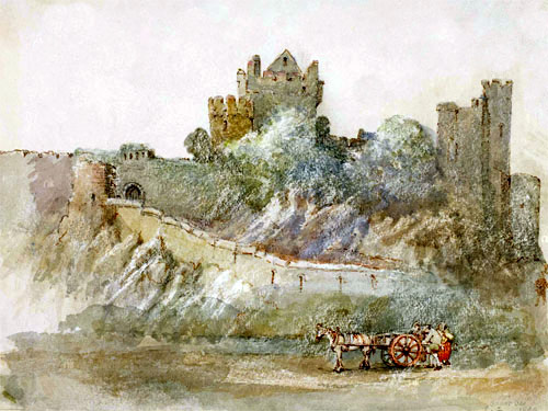
In Co. Tipperary, the spotlight shines brightly on a remarkable collection of historic landmarks, including Cahir Castle, Ormond Castle, Roscrea Castle, and the enchanting Swiss Cottage. These sites, steeped in stories of medieval power, elegant design, and rural life, showcase the county’s extraordinary contribution to Ireland’s built heritage. Many locations across the country have also recently reopened following conservation efforts, adding a renewed sense of discovery for returning and first-time visitors alike.
With no booking required and access granted on a first-come, first-served basis, this is a rare chance to immerse yourself in Ireland’s cultural legacy; completely free of charge. Whether wandering through ancient halls, admiring intricate craftsmanship, or simply soaking up the atmosphere of centuries gone by, tomorrow Wednesday promises a journey through time not to be missed.
Bournea Reaching Out Historical Society PRO Mr Tim Maher Reports:-
The Annual General Meeting of ‘Bournea Reaching Out Historical Society’ was held in Lismackin Hall on February 10th 2026 last. The outgoing Chairman Mr Tim Lee welcomed everyone to this their 13th AGM. He thanked everyone for attending the meeting in the Hall and on their videoconferencing application ‘Zoom’. He told the meeting that the club had yet another great year in 2025. He said they had commenced the year with the AGM in February by electing a new committee. Members had continued with very successful hybrid meetings and it has now become part of their normal meeting each month, over the past few years.
He stated that the club had a great visit to Cahir on their Historical Outing; visiting the Swiss Cottage and Cahir Castle, before meeting up with Mr PJ O’Meara from Cahir’s historical society, who took members on a tour around the town. Finishing in the square, the society went to the Cahir House Hotel where they had a meal, on what was described as a wonderful day, on probably the hottest day of the year.
This year they helped the Hall Committee, by applying for a grant under their name to purchase new tables for Hall.
Mr Lee went on to state, “We had a wonderful morning in Clonakenny at the Norebrook Lounge, when we invited the Tipperary Village Tours Tipp FM team, with Allison Hyland and John G O’Dwyer on Friday June 13th. They interviewed and recorded 12 speakers from all the groups in the parish, with music from Davie Brereton, Michael Ryan, and Michael Doyle. The program was later aired on Tipp FM. All interviews were subsequently transcribed for an article in our 2025 publication. Unfortunately, we didn’t have our annual Historical walk/drive this year, due to certain circumstances. We have done all the surrounding rural areas and maybe it’s time to look closer to home again, as it’s been nine years since we had a walk or drive in our own parish. Mr Paddy Coady launched our 12th volume of “Bournea Reaching Out Historical Society 2025” publication in the Norebrook Lounge. Another great achievement, and sold extremely well. Tim thanked all involved in producing this publication, from the authors to the sellers and many more involved. We also launched our website, which is a brilliant achievement, Tim thanked Emma for all her help to date. We have a lot of work to do with the webpages over the coming months but he had no doubt it will be a brilliant resource going forward. We continue to compile research like the Maher families, school, graveyard, memory card, and other historical data, etc. Our Facebook page and private GEDmatch Discussion group page on both on social media remains ongoing, helping to connect new people searching for their family history in different ways”.
Mr Lee further stated that in June, he submitted his resignation as Chairperson of Bournea Reaching Out Historical Society, with effect from tonight. He said he knew it was a bit of shock to the members and that is why after careful consideration he submitted his resignation last June, to give the society time to organize a new Chairperson. “It is time someone new took on the role and bring new ideas to the job and lead it maybe in a new and better direction for the benefit of our society”, he added.
Mr Lee said he had been Chairperson since their formation first in 2013 and during that time he was more than satisfied with what was achieved in that period. When we started, Mr Lee said he could never have imagined the number of projects the society would complete and that to lead this society into so many projects was indeed a great honour.
Mr Lee said that the proudest moment for him was receiving the Ireland XO Volunteer of the Year National award, on behalf of the society in 2015. This was a Government award, and Minister of State and Diaspora Affairs Mr Jimmy Deenihan and Mr Mike Ferick of Ireland XO presented the awards recognising that out of 500 parishes affiliated with Ireland XO that year, they were the most active, reaching out to the diaspora, who were researching their origins and, most importantly, ensuring that every returning member of the Irish diaspora was greeted with a welcome. Very few knew what we were doing outside the parish before then. That award gave Mr Lee great energy to lead the society at that time and look what they have achieved since. “We completed a lot of projects over the years and I didn’t think there was a year when we didn’t implement a significant project or event. Starting in 2013 with the setting up of Bournea Parish Group; the Ireland XO Presentation Night by Henry Healy; the Brief History of Couraguneen Graveyard booklet; all our lectures e.g. Willie Smyth when he packed the hall in 2014 and George Cunningham 2015, Joe Coughlan & Michael Ward 2016, DNA lecture by Tom Ryan 2018, Larry Breen and Rev. Mgr. Dr Maurice Dooley in 2020, the DNA Lecture by Professor Mark Kennedy 2021; first publication in 2014 to our last volume, 2025 (12 incredible publications); all our Book launches, launched by various distinguished people inside and outside the parish, including the Tipp FM Book Launch 2017; The unavailing of a plaque to Tom Delaney in Clonakenny village 2015. The Way we were project, bringing the Couraguneen Church Door back to life, the Commemoration of Toor to Loran in 2016; the school reunion and the outdoor way we were project in Clonakenny in 2017; all the historical walks mapped in our parish and reaching out to our neighboring parishes to do the walks and help them to record the history of their parishes; managing to continue during the Covid pandemic, by introducing different ways to communicate through Zoom meetings and WhatsApp; the sketch we did during Covid to promote the book in 2021; introducing the hybrid meeting in the hall; introducing the DNA GEDmatch Ancestor Project in 2022; the celebration of ten years in 2023; The Graveyard Projects over the years; the Ellis Island Project; digitizing the School Records; the opening of Jim Kennedy’s Castlepark Museum; and finally the new website we have launched in 2025, not forgetting the many smaller projects completed in the past 13 years that we have recorded in our publications.
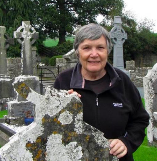
Photo: Newly Elected Chairperson of Bournea Historical Society Ms Christine Timoney.
After The Chairperson’s address, Vice Chairman Mr Michael Costigan paid tribute to Mr Lee on behalf of the whole group. Mr Costigan said he had always a keen interest in local history and was delighted when Mr Lee asked him in 2012 to help him for a new historical group in the parish. Mr Costigan praised Mr Lee for his brain power and knowledge, as well as his patience and persistence. He said so much would have been forgotten, but those stories will now be handed down to the next generation. Researchers will be delighted with the books that we have published. He thanked Mr Lee for all his work and insight, and wished him health and happiness.
This was followed by the election of Officers 2026. Chairperson: Christine Timoney. Vice Chairperson:(Regional) Michael Costigan. Vice Chairperson:(Global) Anne Evola. Secretary: Ann Feehan. Assistant Secretary: Mary Conway. Treasurer: Dick Conroy. Public Relations Officer (PRO): Tim Maher. DNA Project Admin: Gail Hannigan
Committee Members were as follows: Paud Treacy, Aidan Lee, Michael Kiely, Hannah Greed Quigley, Nora Byrne, Margaret Maher, Philomena Hynes.
Newly elected Chairperson. Our new Chairperson, Christine Timoney lives in the city of Melbourne in Australia. She attends our meetings via Zoom every month. Christine Timoney first joined Bournea Reaching Out Historical Society in 2014 when she rented a traditional Irish cottage in Killough for four months from July to early November. The goals of her extended visit from Australia were to experience something of what it might be like to live in rural Ireland, and to reconnect with four distinct lines of Tipperary ancestors.
On one of those four lines, Christine’s maternal grandfather John Costigan left Borrisnoe for Australia in 1882, arriving as a 19-year-old in Sydney with his sister Mary Anne. They were followed seven years later by two more sisters Annie and Hannah.
John Costigan later moved on to Brisbane where in 1901 he married Honorah McMahon of Portroe. The youngest of their children was Christine’s mother Mary Costigan, born 1909. John Costigan died in Brisbane over one hundred years ago, on 30th July 1925.
Like many nineteenth century Irish emigrants, John and his sisters left more brothers and sisters behind in Ireland, and Christine feels very blessed to have reconnected in 2014 with her extended Costigan-Maher family, a great many of whom still live here.
Throughout her childhood Christine was entranced by exotic-sounding place names like Borrisnoe and Devil’s Bit Mountain, and now, having repeatedly achieved her dream of walking in her ancestors’ home places, she has stepped into the role of chairperson – from afar – of Bournea’s vibrant and active historical group. The group now boasts members from across the parish, elsewhere in Ireland and across the world. Their meetings are hybrid: every month the locals meet in Lismackin Hall while others Zoom into the meeting from Ireland, USA and Australia.
At the group’s recent AGM, Christine paid tribute to their impressive thirteen years of achievements under the inspiring leadership of founding chairperson Mr Tim Lee, and pledged to continue the many successful annual projects, including the publication of a fresh volume of Bournea history every year, the popular historical walk/drive each summer, the public history lecture and the members’ annual excursion to places of historical interest.
This year she also hopes to oversee significant progress in oral history interviews with long-time local senior residents,enhancements to the newly launched Bournea website and a thorough study of the movement of families into, out of and within the parish in the nineteenth and early twentieth centuries. For this last project, the group keenly awaits the release of the 1926 census of Ireland, which will be freely available online from 18 April.
Christine pays tribute particularly to the group’s resilience in adapting to the challenges of the pandemic in 2020 and is grateful that their response was to go hybrid with their meetings. This has created a unique environment for cooperation and collaboration between local residents passionate about history and genealogy, and like-minded descendants of Bournea emigrants who moved to othercountries over the past couple of centuries.
Christine thanks Bournea Reaching Out Historical Society for offering her this unique opportunity to make a difference from afar.
The grave of George Plant still attracts annual republican commemorations, while his story remains one of the most striking and contested in Tipperary’s revolutionary past.
Early March each year holds a particularly haunting place in Tipperary history because it marks the anniversary of the execution of Mr George Plant, one of the most controversial republican figures of the early 20th century. On Thursday March 5th 1942, George Plant was executed by military firing squad in Portlaoise jail, bringing a dramatic and deeply disputed chapter of Irish history to a close.
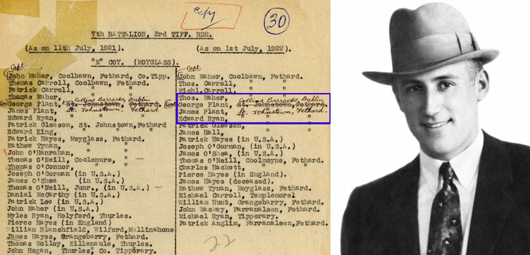
Pictured Left → E Company (Moyglass), 7 Battalion, 3 Tipperary Brigade, IRA, membership list. Pictured Right → George Plant executed by military firing squad in Portlaoise jail, March 1942. The above shows George Plant’s membership during the War of Independence and Civil War, and his change of address to “Collins’ Barracks, Dublin”,where he was tried, convicted and sentenced to death. The James (Jimmy ) Plant also on this list above was George’s brother.
Born on January 5th 1904, at St Johnstown, Fethard, Co. Tipperary, George Plant grew up in a Protestant farming family. The Plant family were known locally as hardworking, strict, and largely removed from politics. Yet George’s life took a decisive turn in 1916, when he and his older brother James were harshly interrogated by the local constabulary about their associations with local republicans including Seán Hayes and Dan Breen. That experience appears to have had a lasting effect on both boys.
By 1918, George and James had joined Na Fianna Éireann, and during the War of Independence and Civil War George served in the Moyglass unit of the 7th Battalion, 3rd Tipperary Brigade, IRA. He earned a reputation for bravery and reliability. Captured near the end of the Civil War, he escaped from Templemore jail and made his way home across country.
After the 1923 ceasefire, George and James emigrated, living and working in Scotland and later across North America. But Plant’s involvement with republican activity did not end. In 1929 the brothers were sentenced to seven years for their part in an IRA bank robbery in Tipperary town. After serving time in Limerick and Portlaoise, George eventually returned to the United States. In 1938, as Seán Russell steered the IRA in a more militant direction, Plant came back to Ireland and by 1940 was on full-time IRA service.
The event that sealed his fate was the killing of Michael Devereux, quartermaster of the IRA’s Wexford battalion. Devereux, wrongly suspected of informing to the gardaí, disappeared in September 1940. His body was not discovered until a year later, after the sensational escape of IRA chief-of-staff Stephen Hayes from IRA custody triggered fresh revelations and investigations.
Plant and IRA Southern Division commander Joseph O’Connor were first charged with Devereux’s murder in the Special Criminal Court. That case collapsed when key witnesses withdrew their statements, claiming they had been beaten and intimidated into making them. However, the government then took extraordinary steps under emergency legislation to retry the matter before a special military court. In a highly controversial move, normal rules of evidence were effectively suspended, allowing previous witness statements to be read into evidence even when those witnesses refused to testify.
On February 27th 1942, George Plant, along with Patrick Davern and Michael Walsh, was convicted and sentenced to death. O’Connor was acquitted on a technicality. Amid widespread public appeals for mercy, the sentences of Davern and Walsh were commuted to life imprisonment, but Plant’s was not. He was executed just days later, on March 5th 1942.
Even decades later, the Plant/Devereux affair remains clouded in controversy. The legal process used to convict Plant has long been criticised as one of the most troubling episodes in Irish judicial history. Later research suggests that Michael Devereux was likely innocent of informing and that Plant was probably involved in his murder. Yet debate continues, shaped by the turbulent politics, secrecy, and emergency powers of that period in wartime Ireland.
In September of 1948, Plant’s remains were returned to his family and reburied at St Johnstown, where his grave still attracts annual republican commemorations.
A series of events will take place in Waterford city this weekend to commemorate the life and legacy of Thomas Francis Meagher, with particular reflection on his role in the Young Ireland rebellion, the rising at Ballingarry in South Tipperary, and the dramatic events that led to his arrest and transportation to Van Diemen’s Land.
Signatures of Thomas Francis Meagher and Patrick O’Donoghue, both arrested at Rathcannon, Holycross, Thurles, Co. Tipperary, following the 1848 Ballingarry (SR) rebellion. Both signatures are written on the back of a prison library book called “Wreath of Friendship”. Picture: G. Willoughby.
Although Meagher is forever associated with raising the tricolour at the Wolfe Tone Confederate Club at No. 33 The Mall in Waterford on Tuesday 7th March 1848, his place in Irish history was shaped just as powerfully by what happened later that year. As one of the leading figures of the Young Irelanders, he became involved in the 1848 rebellion, culminating in the confrontation at Ballingarry, Thurles, Co. Tipperary, in July.
The Ballingarry rising, though unsuccessful, became one of the defining episodes of the Young Ireland revolt. In its aftermath, Meagher was arrested at Rathcannon, Holycross, Thurles, Co. Tipperary, tried for treason, and sentenced to death, a sentence later commuted to transportation to Van Diemen’s Land*. His exile marked a crucial chapter in his life and secured his place among the most significant Irish nationalist figures of the nineteenth century.
* Van Diemen’s Land was the original European name for the island of Tasmania, Australia, used from its 1642 discovery by Abel Tasman, until renamed in 1856. Settled by the British in 1803, it served as a notorious, harsh penal colony for convicts. It is now a state of Australia known for its rugged landscape.
Earlier that same year, Meagher had unveiled what would later become the national flag of Ireland in his native Waterford. The tricolour flew for eight days and nights before being removed by the then British authorities. Speaking about the flag in April 1848, Meagher said: “The white in the centre signifies a lasting truce between Orange and Green and I trust that beneath its folds the hands of Irish Protestants and Irish Catholics may be clasped in generous and heroic brotherhood.”
The tricolour was adopted as the flag of the Irish Free State in 1922 and formally confirmed as the national flag in the 1937 Constitution.
This weekend’s Thomas Francis Meagher 178th Anniversary Tricolour Celebration will see a three-day festival of talks and events take place in Waterford city. Organisers say the festival offers an opportunity not only to reflect on the proud history of the flag, but also to consider Meagher’s wider legacy as a revolutionary, a political exile, and a symbol of Irish resilience.
Sadly, our local Thurles Tourist Office promoters have seen fit to ignore this same 178th Anniversary Tricolour Celebration. Same seem to be keeping themselves busy promoting Facebook posts about local children’s and men’s clothing shops, local nail bars, pubs, cafés, Easter camps, college open days, and Mother’s Day; clearly the kind of world-famous attractions that have international tourists booking flights as we speak. After all nothing says ‘must-visit destination’ quite like a last-minute Easter camp and a half-price manicure. Seriously, while all these Thurles advertised businesses are unquestionably among the very best in their field, same can hardly be seen as unique selling points (USP’s), as far as foreign tourism attractions are concerned, and therefore are about as useful as an ashtray on a motorcycle.
The commemorative weekend opens this evening with the Thomas Francis Meagher Fife and Drum Band performing at the Granville Hotel on Meagher Quay.
Chairperson of the organising committee, Mr Éamonn McEneaney, said the weekend will feature many highlights, including the Friday evening walking tour of the city, four guest speakers at the Medieval Museum on Saturday morning, a gala dinner on Saturday night, and the military parade, wreath-laying ceremony and raising of the flag on Sunday morning.
Bishop Monahan Pays Tribute as Cistercian Community to Leave Roscrea for Mellifont.
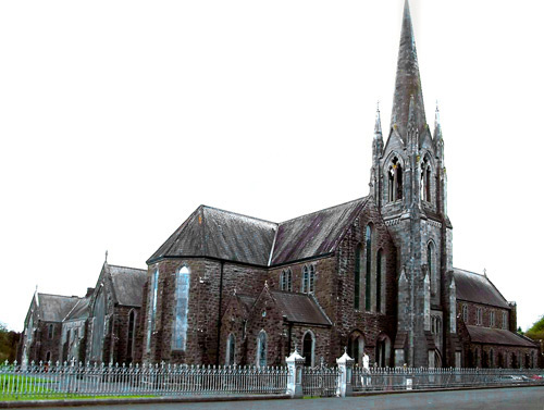
Mount Saint Joseph’s Abbey
Bishop Fintan Monahan of Killaloe has expressed deep sadness following confirmation that the Cistercian Community of Our Lady of Silence Abbey, Roscrea (formerly Mount Saint Joseph’s Abbey), is to relocate to Mellifont Abbey in Co Louth.
The Bishop noted that, since 1878, the abbey has been a cherished and faithful presence in the pastoral life of the Diocese of Killaloe, holding “a special place in the hearts of the people of Roscrea”, including all who prayed and worshipped there, generations of pupils, (former students, included former Taoiseach Mr Brian Cowen and former Tánaiste Mr Dick Spring), and staff connected with the school on the grounds since 1905, and those who benefited from retreats and the hospitality of the guesthouse. He also acknowledged the importance of the farm on the college grounds to the wider local community.
As stated, the abbey was founded in 1878 by a group of 32 monks from Mount Melleray Abbey, County Waterford. A number of years earlier Arthur John Moore MP of County Tipperary had visited Mt Melleray petitioning for it. The church was later opened for worship in 1883, on 600 acres in Mount Heaton, Roscrea, and a Boarding school, Cistercian College, Roscrea, was founded in 1905.
Bishop Monahan paid tribute to the contribution of the monks and school staff to education, highlighting the respected tradition of the boarding school and its strong sporting ethos. He confirmed that the Cistercians will continue as patrons of Cistercian College, ensuring the Cistercian spirit remains central to school life.
He said the abbey’s greatest gift has been its spiritual witness, including the long-standing availability of the Sacrament of Reconciliation and the enduring legacy of figures such as Dom Eugene Boylan OCSO.
While acknowledging local disappointment, Bishop Monahan said he understands the decision follows prolonged prayerful discernment and reflects wider rationalisation in Church life today. He offered gratitude to Dom Rufus and the community, assuring them of prayers and good wishes as they undertake this transition.
This website uses cookies to improve your experience. We'll assume you're ok with this, but you can opt-out if you wish.AcceptRead More
Privacy & Cookies Policy
Privacy Overview
This website uses cookies to improve your experience while you navigate through the website. Out of these, the cookies that are categorized as necessary are stored on your browser as they are essential for the working of basic functionalities of the website. We also use third-party cookies that help us analyze and understand how you use this website. These cookies will be stored in your browser only with your consent. You also have the option to opt-out of these cookies. But opting out of some of these cookies may affect your browsing experience.
Necessary cookies are absolutely essential for the website to function properly. This category only includes cookies that ensures basic functionalities and security features of the website. These cookies do not store any personal information.
Any cookies that may not be particularly necessary for the website to function and is used specifically to collect user personal data via analytics, ads, other embedded contents are termed as non-necessary cookies. It is mandatory to procure user consent prior to running these cookies on your website.


Recent Comments