One such ‘Devils Mark’ or Ordnance Survey Benchmark can be found in Thurles on a pillar close to the road surface, at the entrance to St Bridget’s graveyard at an area formerly known as Garryvicleheen Street, better known today as Abbey Road, west of Thurles town.
Carved into buildings, Churches, bridges and old stone walls across Ireland are these small but remarkable relics of scientific history, known as Ordnance Survey Benchmarks.
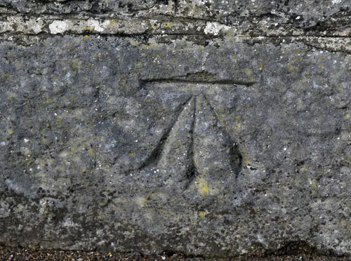
Pic: G. Willoughby.
Though created for science and statecraft, they soon became part of Irish folklore. Particularly in the west of Ireland, where oral tradition recalls that some communities called them the “Devil’s marks,” believing the mysterious cuts were left by dark forces. Same were sometimes smashed in the belief that with these marks, once removed, would ensure that the Devil could not return.
These chiselled symbols, usually a simple crow’s foot cut beneath a horizontal line (view image above), once formed part of a vast system for measuring height above sea level. Known colloquially as “sappers’ marks,” the upward-pointing arrow same contain, was borrowed from the British Government’s ‘broad arrow’ emblem of ownership, repurposed by surveyors as a practical, durable and instantly recognisable tool. At one point the British government issued prison clothing which were stamped with this ‘broad arrow’ emblem, so that people in the towns and villages would know that these individuals were convicts.
The story of benchmarks begins with the Ordnance Survey of Ireland (OSI), established in 1824 under Lt.-Col. Thomas F. Colby. His team carried out the world’s first large-scale mapping of an entire country, culminating in the survey of 1834 and the levelling of Ireland between 1839 and 1843. By 1846, Colby’s monumental effort was complete, leaving behind not only the celebrated six-inch-to-the-mile maps but also a physical legacy inscribed into the landscape.
Each benchmark recorded a precise elevation point, forming a network that allowed engineers, builders, and cartographers to work from a common reference.
Today, a lot of benchmarks still survive as tangible links to Ireland’s first great scientific survey and the progress it represented. Yet they lack any protection status. Modern demolition, redevelopment, road surface levels rising and weathering have already erased from sight, and permanently eradicated many.
Sadly, without awareness and preservation, these modest but historic cuts in stone may in time vanish altogether, along with the stories and the knowledge that they carry.

Leave a Reply