The Unanswered Question: “Will the planned Thurles inner relief road impinge, in a negative way, on the 1846 Thurles “Double Ditch”, which has been a right of way and a Mass Path for almost 175 years and which is the property of the people of Thurles and a national monument?
The Double Ditch Exists
My articles over the last number of weeks have tried to erase any doubt as to the actual existence of a ‘Double Ditch’, at Mill Road, Thurles, Co. Tipperary; thus correcting the nonsense statement by Ms Janice Gardiner (Acting District Manager, Thurles, Municipal District) that, quote, “Tipperary County Council has reviewed all documentation relating to the planning aspects of the Thurles Inner Relief Road Project and can find no reference to the existence of the feature/path/monument you describe.”
It is my firm belief that no review ever took place and this reply, in combination with the ongoing silence from elected Councillors, elected Tipperary Politicians and Council Officials on the matter, has done little to reassure myself and others who care about our town that the “Double Ditch” is safe from destruction. Surely it is reasonable to assume that if the answer to the question asked is not NO, then it must be YES?
Furthermore, same previous articles published were and continue to be aimed solely at sounding alarm bells, ensuring that a piece of our rich Thurles heritage is not placed under serious threat; brought about through either genuine ignorance; wanton deliberate destruction; conplacency or greed, by TD’s we elected to protect our interests, namely Mr Jackie Cahill and Mr Michael Lowry.
The maps, aerial and ground videos, together with primary sources, which I have published and shared, following detailed research regarding this famine period, prove beyond doubt, the very existence of this “Double Ditch”, together with its origins and its massive historical significance.
To this end it must now be developed as an attraction, for what it is currently and for what it can be into the future; to the benefit of the local business community, through correctly marketed tourism and job creation.
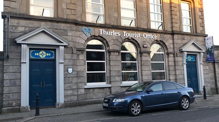
New Tourism Office: We now have a second new tourism office in Slievenamon Road, Thurles. We also have a new Thurles logo, “Halt Awhile”.
But, is this new Tourist Office in Thurles to be used to send our visitors to excellent attractions like Kilkenny castle; Trinity College Dublin; The Guinness Store House, Dublin; the Titanic Centre, Cobh, Co Cork etc. or are we going to try to develop already existing historical attractions within our own town and county?
Currently, all that exists in Thurles is what I call “Hobby Tourism“, with limited attractions unable to open on Saturdays or Sundays, or closed because a relative is “expecting a baby in July”. Indeed I led a walking tour group last year to a visitor centre here in the Thurles area, manned by a reluctant female guide who declared to the visiting group, “I hope ye won’t be long now, my mother is minding my baby”.
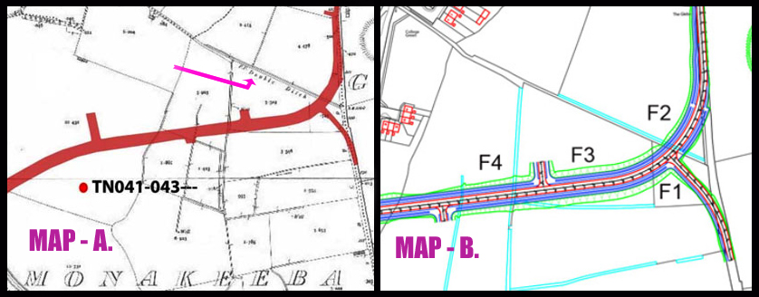
But enough of that; time to examine MAP-B shown above and contained in the Archaeological Impact Study on the inner relief road, undertaken by Mr Frank Coyne(BA MIAI, director of Aegis Archaeology), for client Mr Michael Devery, Road Design, (North Tipperary County Council, Civic Offices, Nenagh, Co. Tipperary.)
In MAP-B our interests are entirely focused on F1, F2, and F3(Shown above) described in the Archaeological Impact Study as quote: – “The subject site is a series of fields. For ease of reporting they were numbered in the direction in which they were walked, from east to west, and numbered F1 to F9.
Field 1 is a small field, covered in short grass and grazed by horses. Field 2 is a large open grassy field, covered in short grass and grazed by horses. Field 3 is a large open grassy field, covered in short grass and grazed by horses. It is very wet underfoot.
Spear Head & Sacrificial Axe Head. The afore mentioned Field 3, which is known as the “Well Field”, was where in 1996 the Monakeeba Bronze socketed spearhead was found, as stated in this same Impact Study.
The Monakeeba Bronze socketed spearhead together with the Monakeeba Stone Age Sacrificial Axe Head, latter found earlier, were both handed over to the National Museum by George Willoughby in 1996. [The Monakeeba Bronze socketed spearhead gets a mention in the Archaeological Impact Study, but for some reason the Stone Age Sacrificial Axe Head found on the Double Ditch was left out].
Please examine the fields again on the above map.
Field (1) bordering the south side of the Famine Double Ditch is small, containing a mere .745 acres. No photograph is taken to provide south to north landscape features, which incorporates the raised Double Ditch. Field (2) bordering the north side of the Famine Double Ditch contains 4.478 acres. No photograph identifies the raised Double Ditch. Field (3) Which contains 3.319 acres, “The Well field”; again no photograph taken to provided south to north landscape, which would incorporate the physical feature of this raised Double Ditch.
All photographs contained in the study were taken from an east to west prospective, so how did the road entrance to the ‘Double Ditch’ shown hereunder, sandwiched between field 1 and field 2 go unnoticed by Mr Coyne and remain unseen, even on road photographs provided in this same Archaeological Impact Study.
The Mill Road, Thurles looking west on the roadside entrance to the Double Ditch. Question; how despite being only 5ft (1.5 metres across) did this entrance, sandwiched between field 1 and field 2, get mysteriously ignored by Aegis Archaeology
Now go back to MAP-A above, again used in the survey and note the cartographers Ref. ‘F.P.Double Ditch‘. Then understand that the same Archaeological Impact Study contains an ‘Aerial View Image’ of that site, showing clearly the ‘Double Ditch’ using the website https://www.bing.com/
Again, as with MAP-A, while the ‘Double Ditch’ is clearly visible (both on the map and the ‘Aerial view Image’), its existence on the landscape has been totally disregarded by the ArchaeologicalImpact Study. Mr Coyne should now be recalled to re-examine his Impact Study.
Silence from Councillors, Politicians and Council Officials.
One thing has been learned from all of this; none of our elected representatives, sad to say, have any interest in promoting Mid-Tipperary tourism, except in the glossy brochures produced every 5 years, one month prior to General Elections or indeed Local Elections.
The now long forgotten Tipperary half promoted marketing ploywhich yielded nothing! Pictured some years ago: (Left)Siobhan Ambrose[Former Council Chairperson FF]; (Centre)FormerEnterpriseMinisterMary Mitchell O’Connor (FG) and (Right)Mr Joe MacGrath[Current CE, Tipperary Co. Co.]
When I set out initially to explore what, if any, new impact developments in our town of Thurles could have upon aspects of our rich history, it was never my intention to anger any individual.
My aim was to ask three questions to reassure both myself and others that valuable aspects of our town’s heritage where not placed in danger of being lost or destroyed.
Two of my three questions were eventually and reluctantly answered. My third question, which related to the possible destruction of the ‘Double Ditch’, was not answered, despite repeated enquiries.
The closest thing to an answer came in the form of an official communication (aforementioned) that clearly skirted around the issue, by essentially stating that there was no record of the “Double Ditch” that I referred to in my question. The implication being that if there was no record, then there was no issue.
This reply, in combination with the ongoing silence from Councillors, politicians and officials on the matter, has done little to reassure myself and the Thurles electorate, that the Double Ditch will remain safe from total destruction.
Finally, it is my strong belief that Tipperary County Council, still intend to totally destroy this piece of valuable history, without the consent of the people of Thurles, thus depriving them of their heritage and a major future tourist attraction.
To be continued.
Part 3 of “Tipperary Co. Co. Intent On Destroying Thurles Heritage” will be published in the coming days.
10 New killer COVID-19 virus cases confirmed in Co. Tipperary
With nearly 8,000 new cases of Covid-19 having been confirmed in Ireland in the past two weeks, the Department of Health have confirmed this evening that there have been sadly 3 new deaths caused by the Covid-19 pandemic; leaving the overall death toll here in the Republic of Ireland remaining at 1,830.
However, there are 811 new additional cases reported today, leaving the current total number of confirmed cases, since conception in the Irish Republic, at 44,159.
Of this evening’s confirmed cases; 10 are in Tipperary(Overall total of 895); 90 in Dublin; 141 in Cork; 62 in Wexford; 51 in Kerry; 50 in Clare; with the remaining 307 cases located across all remaining counties.
Currently hospitalised are 234 Covid-19 patients of which 32 are in ICU’s.
There have been 863 new cases of coronavirus recorded in Northern Ireland and sadly 7 further death.
Total global cases this evening now stand at almost 38 million [37,965,809] with global deaths at almost 1.1 million [1,083,040].
Please do try to make an effort to stay safe by reducing social contacts; avoiding crowds; physically distancing; while wearing face coverings and washing your hands regularly.
Firstly, before we begin, it is necessary to carefully digest the following statement.
It is simply astonishing and somewhat unnerving that, in a democracy, after a 10 week period of asking on numerous occassions a simple question; all elected Thurles Municipal District representatives; plus Tipperary County Council officials (lead by Chief Executive Mr Joe McGrath and Ms Janice Gardiner (latter Acting District Administrator, Thurles) and two elected politicians, namely Mr Jackie Cahill TD and Mr Michael Lowry TD, can wilfully withhold information in relation to a planning query by any member of the public.
Let’s be reminded of the question sent to all the aforementioned elected personnel all paid by you from the public purse.
The Question: “Will the planned Thurles inner relief road impinge, in a negative way, on the 1846 Thurles “Double Ditch”, which has been a right of way and a Mass Path for almost 175 years and which is the property of the people of Thurles and a national monument?”
The Reply: The only single reply received in the last 10 weeks came we think reluctantly from Ms Janice Gardiner(Acting District Manager Thurles), who wrote: “Tipperary County Council has reviewed all documentation relating to the planning aspects of the Thurles Inner Relief Road Project and can find no reference to the existence of the feature/path/monument you describe.”
An Archaeological Impact Study and documented Impact Statement regarding the development of an inner relief road at Thurles, Co. Tipperary, now confirms that Tipperary County Council officials, aided by elected local councillors, are intending to destroy a valuable piece of Thurles history. This is further confirmed by their attempts at secrecy and verbal denial.
The author of the Archaeological Impact Statement for the development of this proposed relief road (ÆGIS REF : 210 -11) was Mr Frank Coyne(BA MIAI, director of Aegis Archaeology, No.32 Nicholas Street, King’s Island, Limerick.); latter company regularly used by Tipperary County Council. Indeed the same company, who on Friday 11th July 2014, undertook the Archaeological Impact Statement for the now completed new carpark on Liberty Square / Slievenamon Road, area of Thurles, under the Thurles and Environs Development Plan 2009-2015.
The client named in this 2013 Archaeological Impact Statement (for the development of this inner relief road at Thurles, Co. Tipperary), was Mr Michael Devery, Road Design, (North Tipperary County Council, Civic Offices, Nenagh, Co. Tipperary.)
Picture shows maps used in this Archaeological Impact Statement by ÆGISin relation to the development of this proposed inner relief road in Thurles, Co. Tipperary. Map A: is the 25 Inch B&W (Same constructed between 1897-1913) and regarded by cartographers as amongst the very finest ever produced.
Map A used in this Archaeological Impact Statement by Mr Frank Coyne, clearly shows “Double Ditch” text by the cartographer, (See small pink arrow in Map A.), yet surprisingly nowhere in this Impact Statement produced does the “Double Ditch” get referenced.
The two letters on the map found before the cartographers text of “Double Ditch” are F.P., which I initially thought represented ‘Famine Project’, however on further research, I discovered same indicated the acknowledgement of a ‘Foot Path’ being in existence.
So we now know that this footpath has been in continuous use for at the last 123 years, according to the map reference itself, (dated 1897), and almost 175 years per page 6 of the original “Minutes of the Thurles & Rahealty Famine Food Committee”, published on website Hidden Tipperary.com. Hence, we have established without doubt that same remains both a “Public Right of Way and as described by other historians, a Mass Path”.
Rights of Way Note: A right of way can be a laneway, or a mere gap in a hedge that leads to property owned by someone who does not own the same laneway or gap in the hedge, and that has been used over a long period of time by that same ‘someone’.
Initially, we understand that same right was only legal if the period of use by that somebody was over 20 years. However since the Land Law and Conveyancing Act of 2009, a person can claim ‘right of way’ if they can prove continuous use for 12 years.
Roads Act 1993. Under the Roads Act 1993, it is the responsibility of local authorities to protect the public’s right to access ‘rights of way’ in each local authority area. Where a local authority proposes to extinguish such public rights of way their requirements under legislation can be found clearly stated HERE in our Irish statute books.
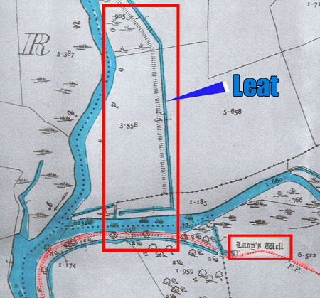
The ‘LEAT’
A ‘Leat’(Same an artificial watercourse or aqueduct. See picture above.), dug into the ground travelling from the area behind today’s St. Patrick’s College to as far as the ‘Lady’s Well’ area, before exiting under the Poulnaneigh River; (same used to remove flood water from the River Suir’s north end and draining it Southward further downstream back into the River Suir) once again, also gets no mention in this Archaeological Impact Statement.
This ‘Leat’was also built during the Great Famine period 1846 – 47 by the same starving Thurles paupers, and their gargantuan efforts from 175 year ago remain clearly visible to this very day.
Were one to view the 1829 – 1842 Ordnance Survey map, latter the first ever large-scale survey of the entire Irish countryside; the ‘Leat’ and the ‘Double Ditch’ are entirely absent, since both projects were not undertaken until 1846/7.
One further question; are the Co. Council engineers aware of the difficulties associated with the building a relief road on a flood plain?
To be continued.
Part 2 of “Tipperary Co. Co. Intent On Destroying Thurles Heritage” will be published in the coming days.
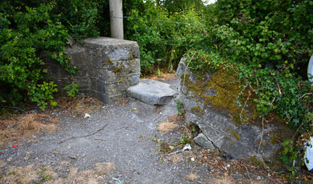
With our Harvest moon waning and Autumn wind, low temperatures and rain prevailing outside today, let us take a virtual walk on the Great Famine “Double Ditch”, starting from the Mill Road side of Thurles, in Co Tipperary.
Warning, during our simulated walk of this existing location, do watch out for the barbed wire. Same was placed on either side by the Thurles Municipal District’s work force, reducing progress along this right-of-way, to single file only.
Yes, since Thurles Municipal District own the land on either side it is highly unlikely that anyone else came in to fence using barbed wire; ergo, they are aware that the public legal right, established by usage over the last 175 years; to pass along this specific route and Mass path, does truly exist. This of course remains contrary to the recent nonsensical statement made by Thurles Acting District Manager Ms Janice Gardiner and former Thurles Acting District Manager Mr. Eamon Lonergan.
Let us chat as we walk: (Ignore the “flytipping’, and burnt-out crab apple trees. Most of the fridges, 3 seater couches, washing machines, vacuum cleaners, beer cans, children’s toys and broken sinks etc. remain covered this Autumn courtesy of Mother Nature, in her effort to hide our shame.)
As we begin our walk, remember this Double Ditch was built by a group of men and boys who understood what it was like to watch their families starve and who had, themselves experienced extreme hunger; something no man, woman or child, thankfully, has to endure or experience, unless wilfully, in our Ireland of the 21st century.
For the Thurles paupers of 175 years ago, the only existing social welfare system that existed, was an overcrowded ‘Workhouse’ from which very few would leave in their own lifetime.
What Is A Double Ditch?
A single ditch is a narrow channel dug at the side of a road or in a field. Its purpose is to either hold, drain or carry away flood water. In Anglo-Saxon, the word ‘dïc’ was pronounced ‘deek’ or ‘deetch’. In digging such a water trench the upcast soil will form into a bank alongside it. This banked soil thus means that the word itself included not just the excavation alone, but also the bank of soil derived from such efforts. Latter word would later evolve into the English words we more commonly use today, e.g.‘dyke’ or ‘ditch’.
Now, if we dig two ditches side by side and you will create a double ditch which in turn creates a high platform in the centre, enabling people to cross extremely wet land without wearing waterproof overshoes (Galoshes) or the then worn leather Wellingtons (Latter first invented around in 1817 and the then privilege only of landed gentry and aristocracy.)
In the case of the Thurles Double Ditch, both sides of the raised platform were faced with limestone; which came free from a stone quarry the property of Rev. Dr. Henry Cotton.
On the day that this Thurles Great Famine work project began, we learn from further hand written communication sent to the Trustees appointed for the distribution of Indian Meal, quote: – “In the town of Thurles alone there are at this moment 768 families containing 3364 inhabitants in actual want; of these 739 are old men, women and children, unable to work and who have no one to labour for them; and the remaining 2625 are depending on the daily hire of the sons and heads of the families to the number of 790 able to work and now out of employment”.
The idea of this Thurles “Double Ditch” was to provide work for paupers unemployed and starving.
The following rules for labourers employed to work on this ‘Double Ditch’ were adopted: –
(1) Hours of labour to be from 7.00am to 7.00pm with 2 hours for meals. (2) Any labourer found to shirk from reasonable and fair work or refusing to follow the directions of his overseer shall forthwith be discharged and not admitted to the works again. (3) That the persons employed shall be paid every evening. (4) That in case of a greater number of labourers shall offer themselves, than the funds will enable the committee to pay. A preference shall be given to those who have the largest and most necessitous families”.
It was further agreed that, quote: –
“Henceforth there be two rates of payment; 8 pence and 5 pence, and that no boy under 12 years old be employed. That tickets of the form now agreed on, should be printed to admit labourers to work – those for men in black ink and those for boys in red ink; Ordered that 500 red and 500 black tickets be printed. Families containing 7 members and over and having 2 men over 17 shall, at the discretion of Committee, be entitled to 2 black tickets; Families having a less number shall, if the Committee wish, get 2 tickets, one red and one black”.
On December 4th 1846, we learn that “In workhouse this day 740 (Persons) – House built to contain 700. Five families were refused admission on Thursday last by the Guardians; in three cases the husband applied with the wife and children stating that he was employed in the public works but that the hire scarcely keeps them alive; in the other 2 cases the wives and children applied without the husbands and stated the hire would not support them. The men offering to support as many of their families as the wages would enable them.”
The Thurles Workhouse
The Thurles Workhouse was built during the period 1841- 1842 to accommodate 700 inmates, on a 6.5 acre site at Castlemeadows, Gortataggart, Racecourse Road, Thurles, Co. Tipperary, (back then known as East New Street). The finished workhouse building was declared fully fit for the reception of the destitute poor on the 25th April 1842 four years before the Great Famine. First admissions however were not received until November 7th of that same year. The workhouse was demolished completely except for a low wall, 16 years ago, in 2004.
Later, with the loss of the potato crop, beginning in the Autumn of 1845; in 1846 sheds to the rear of the main building, originally designed to house straw (latter to make mattresses for beds) and turf (for the provision of heat), would be converted into a 70 bed Epidemic Typhus, Fever Hospital; latter killer disease spread by body lice.
In a report sent from Thurles to the “British Association for the Relief of Extreme Distress in Ireland and Scotland” and forwarded to Lieutenant Col. Douglas on February 11th 1847 we learn; – “Of the population of the united parishes of Thurles, 8,000 are on the relief list. The majority obtains very inadequate relief by employment on Public Works. There are about 300 destitute families having no person to work, to whom gratuitous relief must be given; there are other families varying from 10 to 12 having only one member able to work, whose wages 10p a day would not be adequate to the support of two persons at the present famine prices of food. The poor house built to accommodate 700 has now stowed within 940 and there cannot be any more admissions, and groups who cannot be admitted are to be seen shivering in the cold and wet anxiously expecting the fragments of cold stirabout that remains after the inmate pauper meal. We have lived to see the poor sitting at the pauper’s gate among the crumbs that fall from the pauper’s table. We have not had any deaths from actual starvation but numerous deaths have occurred from severe and long continual privation. The weekly average of deaths has increased fivefold.”
Thurles Municipal District Council in conjunction with Tipperary Co. Co. we believe, now wish to eradicate this important history from our midst, instead of using same to attract much needed and currently non-existent tourism.
You would swear it was a General Election year, then maybe it might be, and if it is, we need to change every solitary TD, we elect to represent our county of Tipperary.
He writes: “I want to give you an update on the work I’ve been doing, and will continue to do, for my home town of Thurles!
Social Housing: 28 units are currently being constructed on the Mill Road. This government is dedicated to providing social and affordable housing. [Note: No mention of attempting to save the 175 year old “Great Famine Double Ditch”, which exists 5 metres (15ft) from where he was standing in his video. We sent 2 emails to Mr Cahill’s email address asking for the answers to 3 simple questions and as was expected from Mr Cahill, we got no reply.]
Jigsaw Centre: this will provide much needed mental health supports for young people in Tipperary.
Third Level Funding: this government has provided €2 million in capital grants for MIC and LIT Thurles campuses as part of the July stimulus.
MIC Thurles: I am working to increase the number of courses available for students, increasing the educational opportunities available in Thurles.
Tourism Office: €2.5 million for a tourism office on the site of the old Lár na Páirce. [You mean, Mr Cahill, the old National Bank building, not Lár na Páirce Museum, surely. By the way it was a €25,000 grant under the Village Renewal Scheme, not €2.5 million; hence the GO FUND ME page started, to try to keep it up and running.]
Hospital of the Assumption: €2.5 million investment in day and respite services for the area. [I thought Mr Alan Kelly TD, in opposition, was responsible for that enterprise before being contradicted by Mr Michael Lowry TD.]
National Apprenticeship Centre: working to increase spaces on offer and I secured €200,000 for Tipperary ETB.
Meanwhile, no mention of his formerly announced pipe dream of a Visitor Heritage Centre for Holycross Abbey, announced by Mr Cahill a week earlier, on 27th September, 2020.
Mr Cahill TD states: [View HERE and do please read the comments underneath for further amusement.]
His press release reads: – “Cahill announces plans for a Multi-million Euro Heritage Centre in the Thurles area.” This development in the Thurles area is believed to have the potential to attract large numbers of international visitors to the area annually. Investments like this are needed in Tipperary to take advantage of opportunities that are likely to emerge as the global pandemic is brought under control. The fact that this project has been able to progress during the Covid pandemic proves to us all that there will be life after Covid, and our area will have a major investment to look forward to. I have been working with stakeholders for some time now on this planned development. Consultations with the local community in the area in question are commencing. Once this process is over, I will be in a position to announce more details. This multi-million Euro development will most definitely be a welcome boost to the mid Tipp region.
[Read the full announcement HERE as Local TippFm Radio broadcasts political deceit. No mention of attempting to save existing 175 year old Thurles heritage.]
The Holycross/ Ballycahill local News Letter on the 27th September 2020, quickly brought TD Mr Jackie Cahill and Thurles Councillor Mr Jim Ryan, back from ‘Fantasy Land’, into the local world of reality and materiality.
The Holycross/ Ballycahill local News Letterstated: – (27th September 2020) “Visitor Heritage Centre: Further to recent media speculation in relation to Holycross Abbey, we wish to point out that there are noplans, drawings, costings or concrete proposals in relation to any development here at this point in time. As has been the case for centuries, our Abbey remains the focal point of our parish for devotion and prayer and that will continue long into the future. If or when there are any further future developments at the Abbey, the people of the parish of Holycross/ Ballycahill should and hopefully will be the first to hear about it.
As you are probably aware from media reports, the Minister with responsibility for OPW (Office of Public Works), Deputy Patrick Donovan made a visit to the Abbey during the week. His predecessor Kevin “Boxer” Moran also made a visit some years ago.
Discussions on possible future development of the OPW portion of the grounds have been taking place over a number of years to see how we can further enhance the area to the benefit of the Abbey and the OPW. Therefore, there is nothing new to report at this point. There are no plans or funding proposals on the table for discussion. Hopefully this will happen at a later stage which, according to the Minister, could take many years to bring to fruition. We are advised that any media speculation is not helpful at this time and may in fact hinder any prospects for the future development.
So Mr Cahill, were you attempting to magnify your currently non-existant profile, to your limited electorate by the use of deceit?
Mr Cahill laughingly continues on his Facebook page:-
“I will continue to push for capital investments in the Thurles area, such as the car park in the town and the development of Liberty Square.” [Note: Carpark & Liberty Square developments were both paid for by the ratepayers of Thurles. Fianna Fáil local councillors voted against that same increase of rates collected to develop Liberty Square, when it was first proposed many years ago.]
Truth is Mr Cahill, you had no hand, act or part in securing or acquiring any one of the assets you claim in your statement, but which you expect the hard working people of Thurles to swallow as truth.
Perhaps the time has come for all TD’s representing Co. Tipperary to either work for their €96,189 per year(€1,850 per week) or fold their tents. Sorry folks, but paying PR staff to associate you with the Met Éireann Weather Forecast on Facebook; with the successful and winning greats like cyclist Sam Bennett, is not actually the work we elected you all to undertake.
This website uses cookies to improve your experience. We'll assume you're ok with this, but you can opt-out if you wish.AcceptRead More
Privacy & Cookies Policy
Privacy Overview
This website uses cookies to improve your experience while you navigate through the website. Out of these, the cookies that are categorized as necessary are stored on your browser as they are essential for the working of basic functionalities of the website. We also use third-party cookies that help us analyze and understand how you use this website. These cookies will be stored in your browser only with your consent. You also have the option to opt-out of these cookies. But opting out of some of these cookies may affect your browsing experience.
Necessary cookies are absolutely essential for the website to function properly. This category only includes cookies that ensures basic functionalities and security features of the website. These cookies do not store any personal information.
Any cookies that may not be particularly necessary for the website to function and is used specifically to collect user personal data via analytics, ads, other embedded contents are termed as non-necessary cookies. It is mandatory to procure user consent prior to running these cookies on your website.


Recent Comments