Firstly, before we begin, it is necessary to carefully digest the following statement.
It is simply astonishing and somewhat unnerving that, in a democracy, after a 10 week period of asking on numerous occassions a simple question; all elected Thurles Municipal District representatives; plus Tipperary County Council officials (lead by Chief Executive Mr Joe McGrath and Ms Janice Gardiner (latter Acting District Administrator, Thurles) and two elected politicians, namely Mr Jackie Cahill TD and Mr Michael Lowry TD, can wilfully withhold information in relation to a planning query by any member of the public.
Let’s be reminded of the question sent to all the aforementioned elected personnel all paid by you from the public purse.
The Question: “Will the planned Thurles inner relief road impinge, in a negative way, on the 1846 Thurles “Double Ditch”, which has been a right of way and a Mass Path for almost 175 years and which is the property of the people of Thurles and a national monument?”
The Reply: The only single reply received in the last 10 weeks came we think reluctantly from Ms Janice Gardiner (Acting District Manager Thurles), who wrote: “Tipperary County Council has reviewed all documentation relating to the planning aspects of the Thurles Inner Relief Road Project and can find no reference to the existence of the feature/path/monument you describe.”
An Archaeological Impact Study and documented Impact Statement regarding the development of an inner relief road at Thurles, Co. Tipperary, now confirms that Tipperary County Council officials, aided by elected local councillors, are intending to destroy a valuable piece of Thurles history. This is further confirmed by their attempts at secrecy and verbal denial.
The author of the Archaeological Impact Statement for the development of this proposed relief road (ÆGIS REF : 210 -11) was Mr Frank Coyne (BA MIAI, director of Aegis Archaeology, No.32 Nicholas Street, King’s Island, Limerick.); latter company regularly used by Tipperary County Council. Indeed the same company, who on Friday 11th July 2014, undertook the Archaeological Impact Statement for the now completed new carpark on Liberty Square / Slievenamon Road, area of Thurles, under the Thurles and Environs Development Plan 2009-2015.
The client named in this 2013 Archaeological Impact Statement (for the development of this inner relief road at Thurles, Co. Tipperary), was Mr Michael Devery, Road Design, (North Tipperary County Council, Civic Offices, Nenagh, Co. Tipperary.)
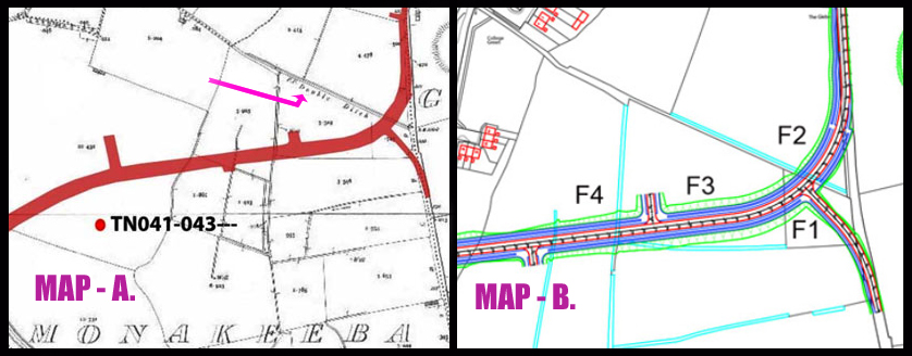
Map A used in this Archaeological Impact Statement by Mr Frank Coyne, clearly shows “Double Ditch” text by the cartographer, (See small pink arrow in Map A.), yet surprisingly nowhere in this Impact Statement produced does the “Double Ditch” get referenced.
The two letters on the map found before the cartographers text of “Double Ditch” are F.P., which I initially thought represented ‘Famine Project’, however on further research, I discovered same indicated the acknowledgement of a ‘Foot Path’ being in existence.
So we now know that this footpath has been in continuous use for at the last 123 years, according to the map reference itself, (dated 1897), and almost 175 years per page 6 of the original “Minutes of the Thurles & Rahealty Famine Food Committee”, published on website Hidden Tipperary.com. Hence, we have established without doubt that same remains both a “Public Right of Way and as described by other historians, a Mass Path”.
Rights of Way
Note: A right of way can be a laneway, or a mere gap in a hedge that leads to property owned by someone who does not own the same laneway or gap in the hedge, and that has been used over a long period of time by that same ‘someone’.Initially, we understand that same right was only legal if the period of use by that somebody was over 20 years. However since the Land Law and Conveyancing Act of 2009, a person can claim ‘right of way’ if they can prove continuous use for 12 years.
Roads Act 1993.
Under the Roads Act 1993, it is the responsibility of local authorities to protect the public’s right to access ‘rights of way’ in each local authority area. Where a local authority proposes to extinguish such public rights of way their requirements under legislation can be found clearly stated HERE in our Irish statute books.
The ‘LEAT’
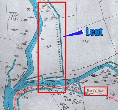
A ‘Leat’ (Same an artificial watercourse or aqueduct. See picture above.), dug into the ground travelling from the area behind today’s St. Patrick’s College to as far as the ‘Lady’s Well’ area, before exiting under the Poulnaneigh River; (same used to remove flood water from the River Suir’s north end and draining it Southward further downstream back into the River Suir) once again, also gets no mention in this Archaeological Impact Statement.
This ‘Leat’ was also built during the Great Famine period 1846 – 47 by the same starving Thurles paupers, and their gargantuan efforts from 175 year ago remain clearly visible to this very day.
Were one to view the 1829 – 1842 Ordnance Survey map, latter the first ever large-scale survey of the entire Irish countryside; the ‘Leat’ and the ‘Double Ditch’ are entirely absent, since both projects were not undertaken until 1846/7.
One further question; are the Co. Council engineers aware of the difficulties associated with the building a relief road on a flood plain?
To be continued.
Part 2 of “Tipperary Co. Co. Intent On Destroying Thurles Heritage” will be published in the coming days.

Leave a Reply