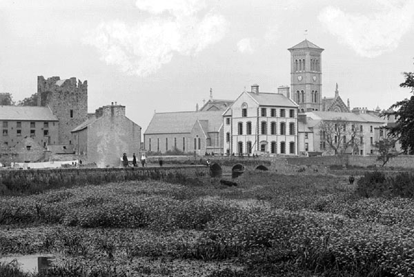
Perhaps one of the most valuable vintage picture postcards of Thurles, Co. Tipperary, currently owned or sought by collectors, is the picture featured here below. Same is usually entitled/labelled “Ursuline Convent, Castle and Cathedral Thurles, Tipperary, Ireland”.
So why is this vintage postcard so highly prized by collectors, I hear you ask? Take a look at it again, and see if you can guess.
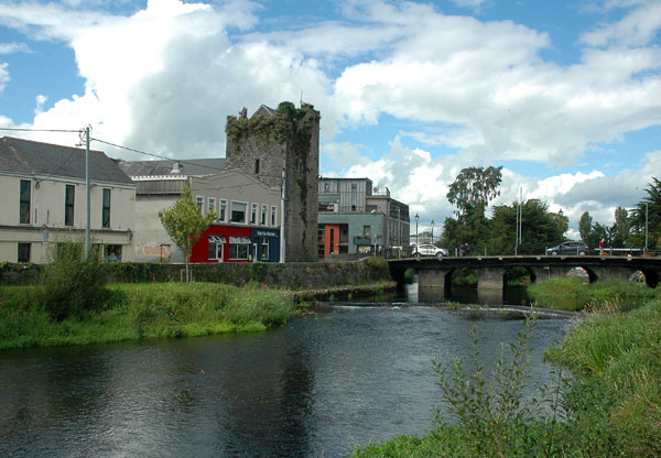
Yes, in reality this image of course does not actually exist. See existing picture hereunder, taken just yesterday 19th August, 2020.
This monochrome vintage picture postcard, photographed around possibly the beginning of the 20th century is indeed a photomontage made up of a series of 2 or perhaps 3 photographs, unless of course our wonderful picturesque Cathedral of the Assumption of the Blessed Virgin Mary building, is slowly slipping eastward, sitting as it does on the edge of the townsland known as “Monacocka”, [Irish – ‘The Shitty Bog’.]
The pictures are indeed the work of a skilled photographer and with the dexterity of an even more experienced photographic printer, sometime later.
From close examination the picture is probably made up of 3 pictures using 3 separate negative of; (1) The River Bed, (2) The Castle, and (3) The Ursuline Convent and Thurles Cathedral, latter one of the few now remaining tourist attractions in Thurles town.
Assuming that the image was printed at the beginning of the 20th century, the printer would have exposed in full, each of the images first, before cutting out masks to cover off and montage each separate image into just one picture.
In the days before the computer editing programme ‘Adobe Photoshop’, same would not have been an easy task to undertake, as each of the 3 images montaged together, would have required different exposure times and precise masking.
Gelatin-coated silver bromide printing paper was coming on stream from 1886, therefore it is most likely that one of the modern upright type photo enlargers, which came into production around 1921, (before ceasing in 2005), was used.
Whatever the time and date of the photographs manufacture, the Cathedral of the Assumption clock informs us that the photographs were taken close to 3:00pm in the afternoon.
Associated Historic Nonsence
The finished historic picture which shows buildings stretched / existing between the 15th century castle and the river however, does make a total nonsense of the claim that “Chieftains would drop fishing lines into the river Suir below. Whoever caught the biggest fish would lay claim to the favourite Wench of the castle.”
This nonsense information exists, suggested to visitors, on a misleading stone plaque erected in 2002, attached to the castle wall. The plaque is long regarded as being totally disrespectful of women, suggesting that rape and / or indeed prostitution was accepted as the ‘order of the day’, during the 15th, 16th and 17th century, or even that women were present in the castle building, itself designed to collect tolls and if necessary defend the river crossing against attack.
This plaque should now be removed, while Liberty Square is being upgraded. Other information on this plaque is also totally misleading to the very few tourists left grinning, that actually do find their way into the Premier County and into Thurles.

I don’t see why the postcard has to be a montage of three separate pictures.
I could be wrong but it looks like the picture was taken further back along the river bank from where the modern picture was taken, perhaps around the location where the pedestrian bridge enters the town park or even further back from that again. In the postcard – if we look at the castle we can see a pitched roof at the top with the gable end of the roof facing roughly south. The small part of the roof we see is facing west – towards Liberty Square. In the modern picture this gable and roof is still visible although the angle has changed meaning the (very small) bit of roof we see is facing east – towards Barrys Bridge and Cathedral Street. This would suggest that the two photographs were taken in two different spots. Also position of the castle could still be beside the river as there is a bend in the river at the point where we see a person sitting on a wall. In modern terms this point would be at the back of Tesco’s on Emmett Street, so the person sitting on the wall is about 100 meters in front of the bridge. The buildings in the postcard picture would then be located along Emmett Street, roughly in the same position as their modern counterparts beside the castle, and not between the castle and the river/bridge as I think you are suggesting
While I agree that the postcard picture could not be recreated nowadays I would suggest that this is due to evolution of the architecture in the area and not antique photoshopping of the original postcard.
Again I could be wrong and I am open to correction.
Yes 1,000mm lenses were all the go in the 1920’s. Trust you will take a photo backing up you theory for publication on this site. No excuses now Garry, get to it while you are cocooning. Count the number of arches under Barry’s Bridge and explain where the buildings east of Liberty Square vanished. Where is Pheasant Island?
I would love to post a picture to back up my theory. Please explain how I do this.
PM me with your picture on facebook.