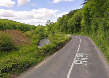
 The R498, a 37km (23m) stretch of regional roadway here in County Tipperary; linking Thurles, via Bouladuff and Borrisoleigh to Nenagh, which was recently severely damaged by extensive flooding, is to be shoring up temporary using large boulders and concrete.
This regional road is an important access route; joining together the North and South Riding’s of Tipperary, latter recently amalgamated into just one single Authority by former Fine Gael Minister Phil Hogan TD, following the last local elections. Following recent severe flooding and overall neglect spanning some ten years; currently this important arterial route servicing North and South Tipp, is now severely curtailing traffic movement; reducing same down to one single lane with access controlled by traffic lights.
Tipperary County Council’s Director of Services for Roads, Mr Marcus O’Connor, has stated that temporary remedial works must now be carried out as a matter of urgency, but warns that a longer term more permanent solution will, into the future, prove expensive; with an expected price tag of some 10 million Euros.
It should be noted that a previous plan by North Tipperary County Council to undertake a structural upgrade of this important arterial route was shelved, following concerns raised by local anglers over its impact on fish stocks in the Nenagh River. The angler’s concerns were taken before the European Commission, latter which ruled that North Tipperary County Council should not proceed with their intended plans. Same it would appear included the introduction of a number of bridge crossings, forced on the North Tipperary Council, because widening and extending of the present road surface area was not seen as an alternative option.
It would now appear that interference by the European Commission, over which Ireland has apparently no influence, could have cost the present amalgamated Tipperary County Council a great deal of money in their efforts to protect a few brown trout, which would have probably been kept out of the river area temporarily in any event.
While the now Irish European Commissioner for Agriculture and Rural Development Phil Hogan was making plans to amalgamate North and South Tipperary, as a then Fine Gael Minister, it would appear God was laughing, looking down on his disastrous and unwanted meddling.

‘Ambush avenue’ or ‘sniper alley’ were some of the nicknames we had for that stretch of road years ago in the belief that during the Troubles (War of Independence) a stretch of road like this linking Thurles with Nenagh, a garrison Town, was ideal topography for such an event and must have seen some action during those times. I was told years later (though I have never had it confirmed) that the Black & Tans, Auxiliaries or British Regular Army never traveled that route from Thurles or Nenagh for those very reasons, instead turning off at Borrisoleigh, or traveling from Nenagh via Templemore to Thurles.
I travel that route too and from Galway to Thurles for the last 17 or so years now, my old classic car takes an awful beating on those roads, I’ve had to replace drop-links three times in five years, wishbones, shocks twice, bushings twice in the last number of years due to the severe wear punishment the car endures on these surfaces. When you get to Urban area’s then it’s the ‘speed bumps’ often the height of these bumps are arbitrarily laid down with little consideration of clearances regardless of your speed. I hear the oil-sump on the bottom of my old babe being scratched on them. Two oil sumps replaced in two years! I love my old car and try to keep her very well maintained, like most I pay a hefty road tax annually.
There are two route alternatives going from Thurles to Galway but you have to eventually cross the Shannon somewhere; either Portumna or Ballina/Killaloe. In summer if you’re in no hurry and enjoy great scenery you head from Thurles out by Ballinahow, Drumbane and on over the Slieve Felim Mountains on through the Silvermines emerging at Birdhill and down into Ballina to cross the Shannon there. Then Tuamgraney (interesting name, derived from Toom an ghréine; ‘The Sun Burial’ similar I suppose to Toomevara; Toom Uí Mhara; ‘Burial place of the O’Meara’s’) on through Scarrif, Loughrea etc.
Similarly for a slightly better surface; Thurles, Templemore, Roscrea, Birr – coming into Birr the road surface is CAT! then as you leave Riverstown outsied Birr the surface deteriorates badly again almost as far as Portumna. No road markings or cats eyes and narrow often flooded without warning, a tough drive in the dark.
Apart from Portumna town itself whose surface always seems to be torn up for some reason and Killimor village the same, Galway council seem to have a better control over the maintenance of their road surfaces. Funny thing is that back in the 1980’s we were constantly hearing about how bad the roads were ‘out west’, well I can tell you that ‘out West’; Galway, Mayo, Sligo & Donegal the road surfaces and finishes are far superior (level and fully marked and cats-eyed)than most roads in Tipperary or Offaly (I can’t believe we are still going on about ‘the state of the roads’ in 2014! 30 or 40 years of it now)
Definitely the most dangerous stretch of road is between Borrisoleigh and Nenagh near the townland of Ballydaly on the R498 just before you arrive at the first roundabout on the Nenagh/Limerick road. After negotiating the ‘ambush avenue & sniper alley’ bends and twists (hoping a lorry wont appear over the imaginary white line & moving fast) the road narrows very dangerously almost without warning, no road markings or cats eyes, no shoulder and heavy trucks coming on at speed throwing up wet and filth onto your windscreen. At night it’s like a horror film! one slip up and you’re gone in under a lorry. This is the main road from Galway City down into Tipperary.
I understand the dilemma the NRA or County Council faces here with severe constraints in widening or stabilising the road due to the lay of the land in certain areas but in fairness; how on earth are we supposed to attract tourists down into the county with access points like these? South Tipperary seems to have done alot better in road upgrades and maintenance over the years.
Kelly’s of Fantane had problems for years outside their quarry, constant huge potholes appeared where trucks were turning in off the road. They finally did a big job on the surface there, I suppose it was bad for business these huge lunar craters appearing constantly outside their place of business. It took months, they had to dig down very deep to get a proper foundation and layered up the material properly before finishing with a thick layer of tarmac. It has stood the test of time and the weight of the fully loaded lorries since.
We had Americans visit us in Thurles a few years back with a new airport hired car and were visibly traumatised after driving that route from Galway one wet spring evening, they were very reluctant to go back that way. The driver said ‘I tell ya, we never experienced anything like that before! we were driving along passed Nenagh towards Borrisoleigh, there was a car tailgating us aggressively but we couldn’t keep in anywhere to let him pass, the bends were so severe and out of the dark large trucks were appearing at speed with full lights blinding us before dimming leaving us dazzled, as they passed within inches of our car a wave of wet and dirt is thrown up onto our windscreen, a few times we nearly ended up in the ditch!’ I said to him: ‘Imagine a cyclist or pedestrian’? He just looked at me and said ‘you’re kidding me man’!